

Fisher Peak State Park

🏔️ Colorado’s Newest State Park — 19,200 Acres Where the Great Plains Meet the Rockies, with a 9,633-Foot Volcanic Mesa, Labor History, and a $25.4 Million Conservation Story — Fishers Peak State Park near Trinidad, Colorado with Fishers Peak summit 9,633ft, 19,200 acres (CO’s 2nd largest SP, opened Oct 2020), Great Plains/Rocky Mountain transition, 3.5-million-year basalt-capped mesa, 16+ miles trails (First Look, Discovery, Challenge, Summit), Santa Fe Trail/Raton Pass, Ludlow Massacre 1914 labor history, Crazy French Ranch, $25.4M Nature Conservancy/TPL/GOCO acquisition, elk/bear/mountain lion/endangered jumping mouse, future 85-100 mi trail network — Las Animas County, CO
For generations, this was the Crazy French Ranch — 19,200 acres of volcanic mesa, grassland, and forest that nobody could visit. In 2019, a $25.4 million conservation partnership changed that. By October 2020, Fishers Peak became Colorado’s 42nd state park and its second largest.
The park tells a story of collisions — Great Plains meeting Rocky Mountains, basalt meeting sandstone, Indigenous peoples meeting Spanish traders, and coal miners meeting corporate power. From the 9,633-foot summit, you can see all of it unfold below.
The Peak
| Feature | Details |
|---|---|
| Summit Elevation | 9,633 ft — highest point in the U.S. east of its longitude |
| Formation | Volcanic mesa — 3.5-million-year-old basalt cap protecting Cretaceous sandstone |
| Profile | Flat-topped, steep-cliffed — differential erosion created the distinctive mesa |
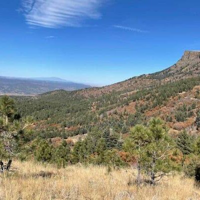
| View | Great Plains stretching east, Sangre de Cristo Mountains (Rockies) to the west |
| Size | 19,200 acres — Colorado’s 2nd largest state park |
Geology
Fishers Peak is a textbook example of differential erosion. A cap of resistant basalt lava — erupted approximately 3.5 million years ago — sits atop softer Cretaceous sedimentary layers, including the Trinidad Sandstone. The basalt has protected the mesa from erosion that carved away the surrounding landscape, leaving the peak standing dramatically above the plains.
The park sits in the Raton Basin, a geological formation rich in coal deposits that extends from southern Colorado into New Mexico. This coal would shape the region’s entire history.
Trails
| Trail | Distance | Difficulty | Highlights |
|---|---|---|---|
| First Look Trail | 0.25 mi | Very Easy | Scenic views of the peak — accessible to all |
| Discovery Trail | Short | Easy | Meadow walk with interpretive signs about geology and ecology |
| Challenge Trail | 1.5 mi | Strenuous | Steep sections exceeding 30% grade — experienced hikers only |
| Osita Point Trail | Varies | Moderate | Dramatic overlook point with panoramic views |
| Summit Trail | Long | Very Difficult | To the 9,633ft summit. Opened late 2023. Substantial preparation required |
| Poison Canyon Downhill | Varies | Moderate | Mountain biking descent through canyon terrain |
| Future Network | 85–100 mi | All levels | Master plan envisions major trail expansion + visitor center |
Wildlife
The park serves as a critical wildlife corridor between the grasslands and mountain ecosystems:
| Species | Notes |
|---|---|
| Elk | Large herds use the park as a movement corridor between plains and mountains |
| Mule Deer | Common throughout the park’s grasslands and woodlands |
| Black Bear | Present in forested areas — store food properly |
| Mountain Lion | Apex predator in the park — rarely seen but present |
| NM Meadow Jumping Mouse | Federally endangered — identified within the park. Critical habitat |
| Raptors | Multiple nesting raptor species — golden eagles, hawks, falcons |
| Wild Turkey | Common in the pinyon-juniper and grassland zones |
History
| Year | Event |
|---|---|
| Ancient | Ute, Apache, and Comanche peoples use the area for centuries |
| 1800s | Santa Fe Trail traders cross Raton Pass below the peak — crucial mountain gateway |
| Late 1800s | Coal mining transforms the Trinidad region. Raton Basin coal fuels railroads and industry |
| 1913–14 | Colorado Coalfield War. Striking miners vs. Colorado Fuel & Iron (Rockefeller) |
| Apr 20, 1914 | Ludlow Massacre — National Guard and hired guards attack striking miners’ tent colony. 21 killed, including 11 children and 2 women. Turning point in U.S. labor history |
| 1914–2019 | “Crazy French Ranch” — 19,200 acres held privately, closed to public |
| Feb 2019 | $25.4M acquisition — Nature Conservancy, Trust for Public Land, GOCO, CPW, City of Trinidad |
| Oct 2020 | Opens as Colorado’s 42nd state park |
| Late 2023 | Summit trail opens to public for first time |
| Future | Master plan: 85–100 miles of trails, dedicated visitor center |
The Conservation Story
How do you turn 19,200 acres of private ranchland into a state park? It took five organizations, $25.4 million, and years of planning:
| Partner | Role |
|---|---|
| The Nature Conservancy | Identified the land’s conservation value. Led initial negotiations |
| Trust for Public Land | Structured the acquisition deal |
| Great Outdoors Colorado (GOCO) | Major funding — lottery proceeds for conservation |
| Colorado Parks & Wildlife | Habitat stamp funds. Now manages the park |
| City of Trinidad | Local government support. Economic development catalyst |
Ecosystem Transition
| Zone | Elevation | Landscape |
|---|---|---|
| Grasslands | ~6,000 ft | Great Plains shortgrass prairie — pronghorn, prairie dogs, meadowlarks |
| Pinyon-Juniper | 6,500–7,500 ft | Transition woodland — wild turkey, mule deer, juniper berries |
| Mixed Conifer | 7,500–9,633 ft | Mountain forest — elk, bear, mountain lion, Gambel oak |
Best Time to Visit
| Season | Weather | Best For |
|---|---|---|
| Fall (Sep–Oct) | 50–70°F | 🏔️ Clear skies, golden grasslands, elk bugling, ideal summit conditions |
| Spring (Apr–Jun) | 45–70°F | Wildflowers, green grasslands, wildlife active, comfortable hiking |
| Summer (Jul–Aug) | 70–85°F | Long days, afternoon thunderstorms at elevation. Start hikes early |
| Winter (Nov–Mar) | 25–45°F | Snow possible at summit. Quieter. Lower trails often accessible |
Frequently Asked Questions
When did Fishers Peak open?
October 2020 — it’s Colorado’s newest and 42nd state park. The 19,200-acre former Crazy French Ranch was acquired in February 2019 for $25.4 million through a coalition of conservation organizations.
How hard is the summit trail?
Very difficult — long distance with significant elevation gain to 9,633 feet. The summit trail opened in late 2023. Recommended for experienced hikers with proper preparation, water, and early starts. The Challenge Trail (1.5 mi, 30%+ grade) gives a taste of the difficulty.
Why is it called “the highest point east of its longitude”?
At 9,633 feet, there is no higher point in the United States at this longitude or any longitude further east. It sits at the exact transition zone where the Great Plains meet the Rocky Mountains — you can literally see both worlds from the summit.
What’s the Ludlow Massacre connection?
The Ludlow Massacre (April 20, 1914) occurred in this region — striking coal miners and their families were attacked by the Colorado National Guard at a tent colony, killing 21 people including 11 children and 2 women. It was a turning point in American labor history. The park’s coal-mining heritage is part of the region’s deep history.
What is the geology?
A 3.5-million-year-old basalt cap (volcanic lava) sits atop Cretaceous sandstone. The hard basalt protected the softer rock below from erosion, creating the flat-topped mesa profile while the surrounding landscape eroded away.
What wildlife might I see?
Elk, mule deer, wild turkey, and raptors are common. Black bears and mountain lions are present but rarely seen. The park also harbors the federally endangered New Mexico meadow jumping mouse.
Is there a visitor center?
Not yet — a dedicated visitor center is part of the future master plan. The park currently has trailheads with parking and interpretive signs. The master plan envisions 85–100 miles of trails.
How does this compare to other Colorado state parks?
It’s the 2nd largest state park in Colorado at 19,200 acres. It’s also the newest (42nd). The conservation story — turning a private ranch into public land — is one of the most significant in recent Colorado history.
What about the Santa Fe Trail?
Fishers Peak overlooks Raton Pass — one of the most critical mountain crossings on the Mountain Branch of the Santa Fe Trail. Traders, armies, and pioneers passed through this gap for centuries. It was the gateway between the Great Plains and the Southwest.
Can I mountain bike?
Yes — several trails including Poison Canyon Downhill are open to mountain biking. The growing trail network includes purpose-built mountain biking trails alongside hiking paths.
🏔️ Colorado’s Newest Park — Where Plains Meet Mountains
19,200 acres of former private ranch, now public. A 9,633-foot volcanic mesa with 3.5-million-year basalt cap, Great Plains-to-Rockies transition, Santa Fe Trail overlook, and growing trail network.
🏛️ The $25.4 Million Conservation Story
How five organizations turned the Crazy French Ranch into Colorado’s 42nd state park — a landmark in American conservation.

Park Location


Top Tours & Activities Near Taos
 from $67
 from $190
 from $92