🌤 Weather at Sutter Buttes State Park by season
| Spring | Summer | Fall | Winter |
|---|---|---|---|
| 44–81 °F | 58–92 °F | 42–89 °F | 38–60 °F |
Each range runs from the coldest monthly average low to the warmest monthly average high in that season (1991-2020 climate normals), measured at Colusa 2 SSW, 13 mi away, elevation 50 ft. Conditions at the park can differ from the station, especially where elevation differs — check a forecast before you go.

California’s World’s Smallest Mountain Range — Dormant Volcanic Formation, Guided Interpretive Hikes Only, 2,122-Foot South Butte Summit, Native American Heritage & Sacramento Valley Views Near Yuba City
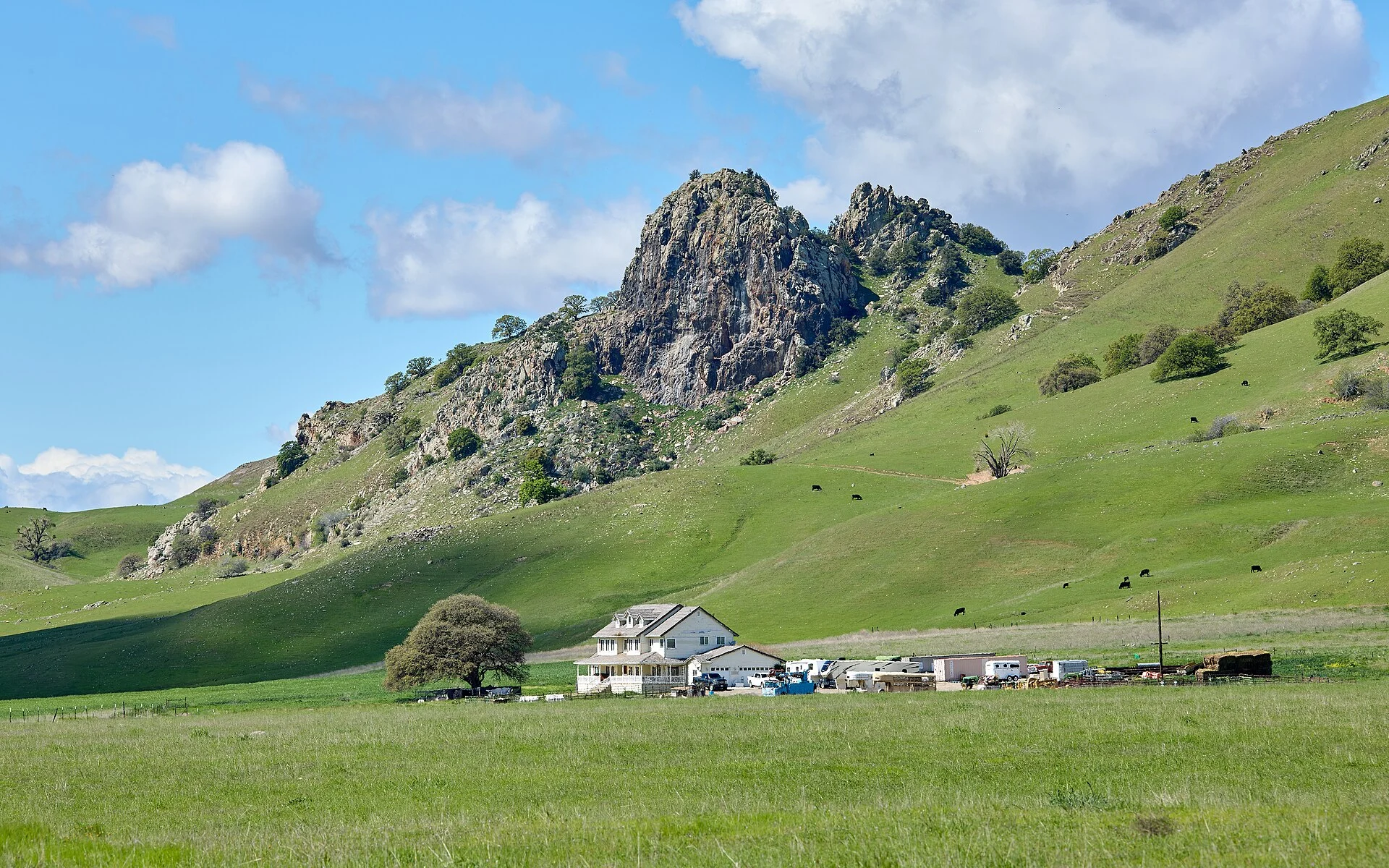
Sutter Buttes State Park is a state park within the Sutter Buttes volcanic formation in Sutter County, California, approximately 60 miles north of Sacramento. The park features the “World’s Smallest Mountain Range” — a dormant volcanic formation rising 2,122 feet from the Sacramento Valley floor, guided interpretive hikes through Middle Mountain (reservation required), Native American cultural significance, spectacular wildflower displays, panoramic views of the Central Valley, and NO general public access (surrounded by private property).
Sutter Buttes State Park protects a portion of one of Earth’s most geologically remarkable landscapes — the Sutter Buttes, often called the “World’s Smallest Mountain Range.” This dormant volcanic formation erupted approximately 1.4 to 1.6 million years ago during the Pleistocene Epoch, creating a dramatic cluster of rugged lava domes rising abruptly from the flat agricultural plains of the Sacramento Valley. The highest point, South Butte, reaches 2,122 feet. The formation spans roughly 10 miles in diameter and is entirely surrounded by private agricultural land — making it inaccessible to the general public without guided access. The primary way to legally explore the Sutter Buttes is through Middle Mountain Interpretive Hikes, offered on weekends from late October through mid-May.
How to Visit
Middle Mountain Interpretive Hikes
- Only legal public access: Docent-led educational hikes
- Organization: Middle Mountain Foundation
- Season: Late October through mid-May (weekends)
- Reservations: REQUIRED — book well in advance (sells out)
- Website: middlemountainhikes.org
Self-Guided Viewing
- Pass Road: Public road cutting through the southern portion
- Perimeter roads: View the formation from surrounding highways
- Photography: Sunrise and sunset provide dramatic silhouettes
Geological & Cultural Significance
Geology
- “World’s Smallest Mountain Range”
- Dormant volcano: Erupted 1.4–1.6 million years ago (Pleistocene)
- Lava domes: Rugged central core surrounded by volcanic debris apron
- South Butte: 2,122 feet — highest point
- Diameter: ~10 miles
Cultural Heritage
- Sacred site: Deeply significant to the Maidu people
- Thousands of years of Native American use
- Pictographs and cultural artifacts documented
Park Information
| Feature | Details |
|---|---|
| Type | State park — NOT open to general public |
| Access | Guided hikes ONLY (Middle Mountain Foundation) |
| Formation | “World’s Smallest Mountain Range” — dormant volcano |
| Highest Point | South Butte — 2,122 feet |
| Age | 1.4–1.6 million years (Pleistocene) |
| Diameter | ~10 miles |
| Location | Sutter County — 60 mi N of Sacramento, 11 mi NW of Yuba City |
| Facilities | NONE — no public trails, restrooms, or parking |
| Camping | Not permitted |
| Trespassing | Unauthorized entry = trespassing (private land) |
Guided Hike Season
| Season | Highlights | Considerations |
|---|---|---|
| Spring (Mar–May) | ⭐ BEST: Spectacular wildflower displays; green hillsides; birding; comfortable hiking | Book early — sells out; ticks; variable weather |
| Fall (Oct–Nov) | Hike season begins; golden grasslands; raptors; cool weather; photography | Brown hills; rattlesnakes (early fall); limited dates |
| Winter (Dec–Feb) | Hikes continue; green-up begins; solitude; foggy valley views | Cold; fog may obscure views; wet terrain; mud |
| Summer (Jun–Sep) | NO hikes — season closed; view from perimeter roads only | Extreme heat (100°F+); dry; fire danger; no access |
Visitor Tips
- NOT open to the public: Do NOT attempt to enter — the Sutter Buttes are entirely surrounded by private agricultural land. Unauthorized entry is trespassing.
- Book guided hikes early: Middle Mountain Interpretive Hikes are the only legal way to hike the Buttes. They sell out quickly — book at middlemountainhikes.org.
- Pass Road: Drive Pass Road (public) through the southern portion for views without a reservation.
- Wildflowers: Spring (March–April) brings spectacular wildflower blooms on the volcanic hillsides.
- Rattlesnakes: Western rattlesnakes are present — watch your step on guided hikes.
- Cultural respect: The Sutter Buttes are sacred to the Maidu people — treat the landscape with reverence.
Wildlife & Nature
Sutter Buttes SP — on the Sutter Buttes — the world’s smallest mountain range — rising 2,000 feet from the flat Central Valley floor. Sacred to the Maidu people. The buttes’ volcanic peaks, grassland, and oak woodland support golden eagles, tule elk, and peregrine falcons.
Nearby Attractions
Yuba City — nearby. Sutter County — surrounding. Sacramento — 50 miles south.
Frequently Asked Questions
Can you hike in Sutter Buttes State Park?
Only through guided interpretive hikes organized by the Middle Mountain Foundation. Sutter Buttes State Park is not open to the general public — the entire volcanic formation is surrounded by private agricultural land, and unauthorized entry constitutes trespassing. Guided hikes are offered on weekends from late October through mid-May and require advance reservations at middlemountainhikes.org. The Sutter Buttes are known as the “World’s Smallest Mountain Range” and are a dormant volcano rising 2,122 feet from the Sacramento Valley floor in Sutter County, California.
Why is Sutter Buttes called the World’s Smallest Mountain Range?
The Sutter Buttes are called the “World’s Smallest Mountain Range” because they are a compact, isolated volcanic formation spanning only about 10 miles in diameter, rising abruptly from the flat Sacramento Valley floor. They were formed by volcanic activity approximately 1.4 to 1.6 million years ago during the Pleistocene Epoch. The highest point, South Butte, reaches 2,122 feet. The formation is sacred to the Maidu people and is now partially protected as Sutter Buttes State Park, though public access is limited to guided hikes only.
Last updated: May 2026
Keep exploring: The closest neighbor is Colusa-Sacramento River State Recreation Area (a short drive away).

🐾 Dogs & Pets at Sutter Buttes State Park
- Pets allowed? statewide rule
- Dogs are permitted in California State Parks only in developed areas — campgrounds, picnic areas, parking lots and paved roads — and are prohibited on most trails, beaches and undeveloped areas unless specifically designated as dog-friendly.
- Leash rule statewide rule
- Maximum 6-foot leash at all times; dogs may not be left unattended.
- Beaches & swim areas statewide rule
- Dogs are prohibited on most state beaches; only beaches specifically designated as dog-allowed permit them (varies by park).
- Cabins & lodging statewide rule
- Pets are generally not allowed in buildings or cabins; overnight campers must keep dogs inside a tent or vehicle at night.
- Statewide exceptions statewide rule
- Designated dog-friendly trails and beaches vary park by park; misrepresenting a pet as a service animal is a misdemeanor.
Are dogs allowed at Sutter Buttes State Park?
Dogs are permitted in California State Parks only in developed areas — campgrounds, picnic areas, parking lots and paved roads — and are prohibited on most trails, beaches and undeveloped areas unless specifically designated as dog-friendly. Individual parks can post stricter rules — check signage on arrival.
Rules verified July 2026 via parks.ca.gov. More: California state parks guide · Dog rules in all 50 states compared
Park Map
Plan your gear for Sutter Buttes State Park
From our editorial guides, matched to this park’s activities: