🏆 National Historic Landmark — The epicenter of Red Cloud’s War and the most dangerous posting on the entire American frontier (1866–1868)
Stand on the high ground where Fort Phil Kearny once stood and look north. The Bighorn Mountains rise in a massive wall of snow-capped granite to the west. The rolling grasslands of the Powder River country spread endlessly to the east. And somewhere out there, along a ridge you can actually see from here, 81 American soldiers marched into the most devastating ambush of the Plains Indian Wars — and not a single man survived.
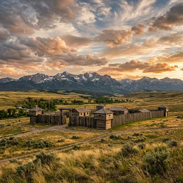
This is not a reconstructed tourist fort with gift shops and costumed actors. Fort Phil Kearny State Historic Site is something rawer and more powerful: a 713-acre landscape where the foundations of the original stockade are still visible in the earth, where the wind carries the same sound it made in 1866, and where two of the most significant battles in American frontier history took place within sight of the fort’s former parade ground. The Fetterman Fight. The Wagon Box Fight. Red Cloud’s War. These aren’t just chapter headings in a textbook — they happened here, on ground you can walk today.
Located 17 miles north of Buffalo, Wyoming, just off Interstate 90, this National Historic Landmark preserves the story of a fort that existed for only two years (1866–1868) but shaped the course of Western expansion, Native American resistance, and U.S. military policy for a generation. The excellent interpretive center provides the context, and the landscape provides the emotion. Together, they create one of the most moving historical experiences in the American West.
Table of Contents
The Bozeman Trail
To understand Fort Phil Kearny, you first need to understand the road it was built to protect. The Bozeman Trail, blazed by John Bozeman in 1863, was a shortcut from the Oregon Trail through the Powder River Basin to the gold fields of Montana Territory. It was faster and more direct than the alternative routes — and it cut directly through the heart of the finest hunting grounds remaining to the Lakota, Northern Cheyenne, and Arapaho nations.
These weren’t marginal lands. The Powder River country was the last great buffalo range on the northern Great Plains, and the tribes who depended on it understood that allowing a permanent road to carve through the region would eventually destroy their way of life. When the U.S. Army arrived in the summer of 1866 with orders to build forts along the trail, the stage was set for one of the most intense military confrontations in the history of the American West.
Building the Fort (1866)
Colonel Henry B. Carrington arrived at the site in July 1866 with approximately 700 soldiers and orders to construct a fort that would protect Bozeman Trail travelers. The location he selected — a plateau between Big Piney and Little Piney Creeks at an elevation of about 4,900 feet — offered excellent sight lines and access to water and timber. It was also, as events would prove, surrounded on virtually every side by terrain that favored ambush.
The fort Carrington built was substantial: a massive pine-log stockade approximately 600 by 800 feet, containing barracks, officer’s quarters, a hospital, a magazine, workshops, and storage buildings for over 700 people. At its peak, it was the largest military installation on the northern Great Plains. But from the day construction began, the garrison was under siege. Warriors maintained nearly constant surveillance of the fort, attacking wood-cutting parties, running off livestock, and killing soldiers who ventured too far from the stockade walls.
📊 Fort Phil Kearny by the Numbers
• Garrison size: Approximately 350–700 soldiers (varied by season)
• Stockade dimensions: ~600 x 800 feet, log construction
• Duration of operation: July 1866 – August 1868 (2 years)
• Hostile engagements in 1866 alone: Over 50 attacks recorded
• Soldiers killed during the fort’s operation: 154
• Fate: Burned by Cheyenne warriors within hours of U.S. Army departure
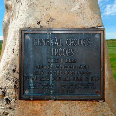
The Fetterman Fight (December 21, 1866)
The defining event of Fort Phil Kearny — and one of the most significant battles of the entire Indian Wars — occurred on a bitterly cold December morning when Captain William J. Fetterman led a relief force of 81 men to rescue an attacked wood train. It was a trap.
A small group of decoys, which included a young warrior named Crazy Horse, lured Fetterman’s command over Lodge Trail Ridge — the very ridge that Carrington had repeatedly ordered his officers never to cross. On the far side, approximately 1,000 to 2,000 Lakota, Cheyenne, and Arapaho warriors waited in concealment.
The fight lasted approximately 40 minutes. All 81 soldiers were killed — the worst military defeat suffered by the U.S. Army on the Great Plains until the Battle of the Little Bighorn a decade later. The Lakota called it the “Battle of the Hundred-in-the-Hands” (the predicted number was close to the actual count). The U.S. Army called it a massacre. Both names reflect the totality of what happened on that frozen ridge.
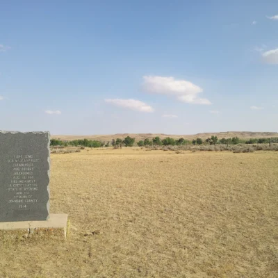
The Fetterman battlefield is located approximately 4 miles north of the fort site and is accessible by car. A monument marks the location where the command made its last stand, and interpretive signs explain the movements of both forces. Standing there in winter, with the wind howling across the open ridge, is one of the most viscerally powerful experiences you can have at any American battlefield.
The Wagon Box Fight (August 2, 1867)
Eight months after the Fetterman disaster, the fort’s soldiers got a chance at redemption — and new technology made the difference. On August 2, 1867, a wood-cutting detail of 32 soldiers and civilians was attacked by a large Lakota force estimated at 500 to 1,500 warriors. But this time, the soldiers were equipped with new Springfield Model 1866 breech-loading rifles that could fire far more rapidly than the muzzle-loaders used during the Fetterman Fight.
The soldiers formed a defensive corral using the boxes from wood-supply wagons, and from behind this improvised fortification, they maintained a devastating and continuous fire that repelled wave after wave of attacks over several hours until reinforcements arrived from the fort. The engagement demonstrated the transformative power of repeating arms technology and marked a tactical turning point in Plains warfare.
The Wagon Box Fight site is located approximately 1.5 miles west of the fort and is freely accessible year-round with a monument and interpretive panels.
Red Cloud’s Victory
Despite the tactical success at the Wagon Box Fight, the strategic reality was unmistakable: the Bozeman Trail forts were untenable. Red Cloud’s War — the sustained, organized resistance led by the Oglala Lakota chief — had made the road too dangerous for civilian travel and too expensive for the military to maintain. In the Treaty of Fort Laramie (1868), the U.S. government agreed to abandon all three Bozeman Trail forts — Fort Reno, Fort Phil Kearny, and Fort C.F. Smith — and close the road.
It was the only war in American history in which Native American forces achieved all of their strategic objectives. The troops marched out of Fort Phil Kearny in August 1868, and Cheyenne warriors burned the stockade to the ground within hours. The charred ruins gradually disappeared into the prairie, and the land returned to the buffalo and the people who depended on them — at least for another decade, until the final surge of Plains settlement overwhelmed everything in its path.
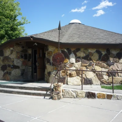
Interpretive Center & Exhibits
The Interpretive Center is the starting point for any visit and provides essential context that transforms the landscape from “empty field” to “one of the most dramatic stages in American history.”
| Feature | Description |
|---|---|
| 🏛️ Main Exhibit Hall | Chronological timeline of the Bozeman Trail conflict with artifacts, weapons, and documents |
| 🗺️ Fort Diorama | Detailed scale model showing the complete fort as it appeared in 1867 |
| 🎬 Orientation Film | 20-minute documentary covering the military and Indigenous perspectives |
| 📚 Bookstore | Excellent selection on the Indian Wars, Western expansion, and tribal histories |
| 🔬 Archaeological Displays | Excavated artifacts from the fort site and battle locations |
Walking the Grounds
The fort grounds are accessible via a network of interpretive trails that lead you through the footprint of the original stockade. Foundation outlines, building locations, and strategic positions are marked with signs that help you visualize the complex that once stood here.
| Route | Distance | Difficulty | Highlights |
|---|---|---|---|
| Fort Grounds Loop | 0.8 miles | Easy | Stockade outline, building foundations, parade ground |
| Piney Creek Trail | 1.2 miles | Easy | Creek access, timber cutting zone, wildlife |
| Outlook Ridge | 0.5 miles | Easy | Panoramic views, Bighorn Mountains, approach routes |
Battle Sites
| Site | Distance from Fort | Access | Features |
|---|---|---|---|
| ⚔️ Fetterman Battlefield | 4 miles north | Paved road, free | Monument, interpretive signs, ridge walk |
| ⚔️ Wagon Box Fight Site | 1.5 miles west | Gravel road, free | Monument, battle description panels |
⚔️ Visiting the Battle Sites
• Fetterman Battlefield: The most powerful experience at the site. Walk the actual ridge where the command was overwhelmed. The terrain tells the story — you can see how the decoys drew Fetterman over the ridgeline and out of sight of the fort. Visit on a cold December day for the full emotional impact.
• Wagon Box Fight: A quieter site but equally significant. The open meadow where the wagon box corral stood gives you a visceral sense of how exposed the soldiers were — and how transformative the new rifles proved to be.
• Both sites are free and open year-round from sunrise to sunset, regardless of Interpretive Center hours.
Visitor Information
| Detail | Information |
|---|---|
| 📍 Address | 528 Wagon Box Road, Banner, WY 82832 (I-90, Exit 44) |
| 📞 Phone | (307) 684-7629 |
| 🕐 Summer (Jun–Sep) | Daily 8:00 AM – 5:00 PM |
| 🕐 Shoulder (May & Oct) | Wed–Sun 12:00 PM – 4:00 PM |
| 🕐 Winter (Nov–Apr) | Fri–Sun 12:00 PM – 4:00 PM (or by appointment) |
| 🕐 Grounds & Battle Sites | Year-round, sunrise to sunset |
| 💰 WY Residents | $4 per person |
| 💰 Non-Residents | $8 per person |
| 💰 Children under 18 | Free |
| 💰 Battle Sites | Free (always) |
| 🐕 Pets | Allowed on grounds (leashed), not in Interpretive Center |
Best Time to Visit
| Season | Weather | Center Hours | Best For |
|---|---|---|---|
| ☀️ Summer (Jun–Sep) | 70–90°F | Daily 8AM–5PM | Full access, ranger programs, comfortable walking |
| 🍂 Fall (Oct) | 40–65°F | Wed–Sun 12–4PM | Autumn color in Bighorns, fewer visitors, atmospheric |
| ❄️ Winter (Nov–Apr) | 10–35°F, snow | Fri–Sun 12–4PM | Fetterman site in winter is deeply moving |
| 🌸 Spring (May) | 45–65°F | Wed–Sun 12–4PM | Wildflowers, wildlife emerging, green prairie |
The June through September window offers daily access to the Interpretive Center and the best conditions for exploring the grounds and battle sites. However, serious history enthusiasts should consider a December visit — standing at the Fetterman monument on a cold, windy winter day, with snow on the ground and the sky pressing low, puts you as close to December 21, 1866 as you can get.
Nearby Attractions
| Destination | Distance | Highlights |
|---|---|---|
| Jim Gatchell Memorial Museum | 17 miles (Buffalo) | Outstanding Indian Wars and frontier collection |
| Little Bighorn Battlefield | 130 miles north | Custer’s Last Stand — the sequel to the story that started here |
| Bighorn National Forest | Adjacent | Cloud Peak Wilderness, alpine lakes, scenic drives |
| Independence Rock | 190 miles south | Oregon Trail landmark, inscriptions |
| King’s Saddlery Museum | 35 miles (Sheridan) | Cowboy heritage, saddle craftsmanship |
Photography Guide
📸 Best Photography at Fort Phil Kearny
• Golden hour at the fort grounds: The late afternoon sun backlights the Bighorn Mountains from the fort site. Use the remaining foundation markers as foreground interest against the mountain backdrop.
• Fetterman Monument: Most powerful in dramatic light — early morning or storm-approaching conditions. The stark monument against endless prairie sky is an iconic Western image.
• Winter photography: Snow-covered battle sites with low winter sun create haunting, powerful images. Dress for extreme cold — wind chill can be brutal at these exposed locations.
• Panoramics: The 360° views from the fort grounds and the Fetterman ridge demand wide-angle treatment. Consider a panoramic stitch or use a 16–24mm lens.
Frequently Asked Questions
What happened at Fort Phil Kearny?
Fort Phil Kearny was a U.S. Army outpost built in 1866 to protect travelers on the Bozeman Trail through present-day Wyoming. It became the epicenter of Red Cloud’s War — a two-year conflict between the U.S. military and a coalition of Lakota, Cheyenne, and Arapaho warriors. The fort was the site of the Fetterman Fight (December 1866), in which 81 soldiers were killed in an ambush, and the Wagon Box Fight (August 1867). The fort was abandoned under the Treaty of Fort Laramie in 1868 and burned by Native warriors shortly after.
Is the original fort still standing?
No. The fort was burned to the ground by Cheyenne warriors within hours of the U.S. Army’s departure in August 1868. Today, the site preserves the footprint of the original stockade — foundation outlines and building locations are visible and marked with interpretive signs. A scale diorama in the Interpretive Center shows what the fort looked like at its peak.
How much does it cost to visit Fort Phil Kearny?
The Interpretive Center charges $4 for Wyoming residents and $8 for non-residents. Children under 18 enter free. Both the Fetterman and Wagon Box Fight battle sites are free to visit year-round, regardless of whether the Interpretive Center is open.
Can you visit the Fetterman battlefield?
Yes. The Fetterman Fight site is located approximately 4 miles north of the fort and is accessible by paved road. It features a monument, interpretive signage, and the actual terrain where the engagement took place. The site is free and open year-round from sunrise to sunset. Maps are available at the Interpretive Center.
Is Fort Phil Kearny open in winter?
The fort grounds and both battle sites are open year-round from sunrise to sunset. The Interpretive Center has reduced winter hours — typically Friday through Sunday, 12:00 PM to 4:00 PM (November through April). Visits outside these hours can often be arranged by appointment. Call (307) 684-7629. Winter road conditions can sometimes limit access; check Wyoming road conditions at wyoroad.info before traveling.
How long should I plan for a visit?
Plan for a minimum of 2 to 3 hours: approximately 45 minutes for the Interpretive Center, 30 minutes walking the fort grounds, and 30 minutes each at the Fetterman and Wagon Box battle sites (including driving time between them). History enthusiasts and photographers could easily spend 4 to 5 hours exploring the full site, especially if weather conditions are good for walking the ridge at the Fetterman battlefield.
What’s the connection between Fort Phil Kearny and the Little Bighorn?
The connections are direct and personal. The young warrior Crazy Horse, who served as one of the decoys at the Fetterman Fight in 1866, was a key leader at the Battle of the Little Bighorn ten years later. Red Cloud’s War — centered on Fort Phil Kearny — was the first major organized military resistance by Plains tribes, and its success emboldened further resistance that culminated at the Little Bighorn in 1876. Visiting both sites (they’re about 130 miles apart) creates one of the most powerful frontier history itineraries in the American West.
⚔️ Visit Fort Phil Kearny State Historic Site
Walk the ground where Red Cloud’s War was fought and won. The Interpretive Center, fort grounds, and two battle sites tell one of the most dramatic stories in American frontier history — and the landscape has barely changed since 1866.
🗺️ Official Site Info & Hours 🏔️ Plan Your Wyoming TripFrequently Asked Questions
How much does it cost to visit Wyoming state parks?
A daily use fee of $7 per vehicle for residents and $12 for non-residents applies. An annual day-use permit costs $42 for residents and $77 for non-residents.
What are the best state parks in Wyoming?
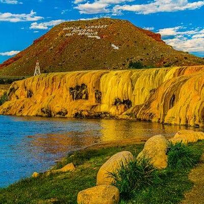
Top parks include Hot Springs (natural hot spring pool and waterfall), Sinks Canyon (disappearing river), Boysen (Wind River Canyon reservoir), and Glendo. They complement nearby national parks like Yellowstone and Grand Teton.
Can I soak in hot springs at a Wyoming state park?
Yes, Hot Springs State Park in Thermopolis features free public soaking in natural hot spring pools fed by the world’s largest mineral hot spring. The park also features a waterfall on the Bighorn River.
What is the best time to visit Wyoming state parks?
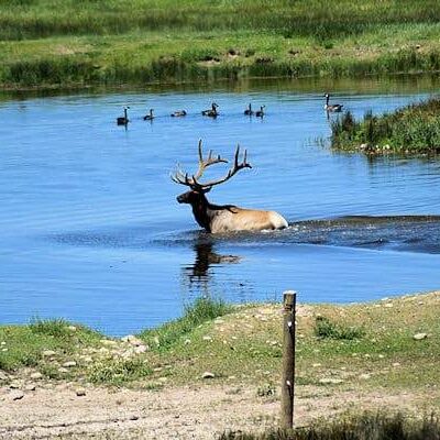
Summer (June-August) is the primary season with warm days and cool nights. Fall offers stunning golden aspens and elk viewing. Spring is muddy and cold until June. Winter is harsh with heavy snow at elevation.
Explore More Wyoming State Parks
Fort Phil Kearny is one of many outstanding state parks in Wyoming. Discover more parks in our Best State Parks in Wyoming guide, or use our Park Finder to search by activity, location, or features.

Park Location

Top Tours & Activities in Wyoming
 from $1,999
 from $2,443
 from $548