
🌤 Weather at Julia Pfeiffer Burns State Park by season
| Spring | Summer | Fall | Winter |
|---|---|---|---|
| 43–70 °F | 48–77 °F | 45–77 °F | 42–61 °F |
Each range runs from the coldest monthly average low to the warmest monthly average high in that season (1991-2020 climate normals), measured at Big Sur Stn, 9 mi away, elevation 200 ft. Conditions at the park can differ from the station, especially where elevation differs — check a forecast before you go.

🌊 Guide to Big Sur’s Iconic Waterfall
Where a Waterfall Meets the Pacific
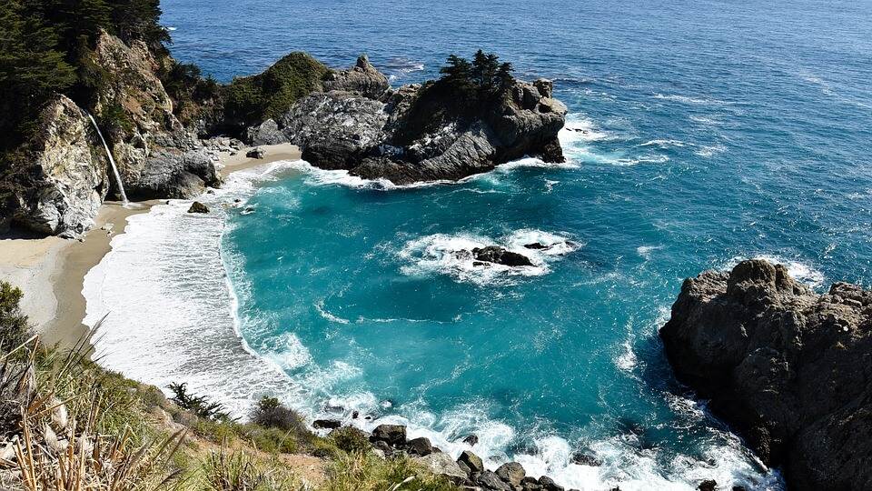
On California’s legendary Big Sur coast, Julia Pfeiffer Burns State Park protects 3,762 acres from rocky shoreline to the heart of the Santa Lucia Mountains — but its global fame rests on a single breathtaking sight: McWay Falls, an 80-foot waterfall that cascades over granite cliffs directly onto a pristine beach or into the turquoise Pacific, depending on the tide. One of only two coastal waterfalls in California, McWay Falls is among the most photographed natural landmarks on the West Coast. Yet this park offers far more than its famous waterfall — ancient redwood groves, rugged coastal trails, a 1,680-acre underwater marine reserve, and the raw, untamed beauty that defines Big Sur.
Quick Facts
| Detail | Information |
|---|---|
| Location | Highway 1, Big Sur, Monterey County, CA |
| Established | 1962 |
| Size | 3,762 acres (land) + 1,680 acres (underwater) |
| Hours | 8:00 AM to Sunset, daily |
| Day-Use Fee | $10 per vehicle |
| Camping | 2 environmental walk-in sites (reservation required) |
| Distance from Carmel | 37 miles south on Highway 1 |
| Max Vehicle Length | 22 feet (no RVs, no trailers) |
| Pets | Not allowed on trails or in campground |
The History Behind the Name
Julia Pfeiffer Burns (1868–1928) was a beloved Big Sur pioneer and rancher who spent most of her life along this rugged coast. Born near the park’s present boundaries, she was known throughout the community for her warmth, resilience, and deep connection to the land. The property itself was originally homesteaded in the late 1870s by Christopher and Rachel McWay — the namesakes of McWay Falls and McWay Creek.
In 1924, Lathrop and Hélène Hooper Brown purchased the McWay ranch and built a modest home on the bluffs above the cove. After Lathrop’s passing, Hélène donated the land to the State of California in 1961 with a single stipulation: that the park be named in honor of her close friend, Julia Pfeiffer Burns. The park was officially established in 1962, preserving one of Big Sur’s most dramatic coastlines for future generations.
The landscape continued to evolve after the park’s creation. In 1983, a massive landslide deposited debris into McWay Cove, creating the sandy beach that visitors see today. Before the slide, McWay Falls plunged directly into the ocean — a true tidefall. At high tide, the Pacific still reaches the base of the falls, maintaining its rare tidefall status.
McWay Falls
The McWay Falls Overlook Trail (0.6 miles round trip, wheelchair accessible when open) delivers one of California’s most unforgettable views: a ribbon of water plunging 80 feet from a notch in the sea cliffs to the beach below, framed by turquoise water and windswept cypress. The beach itself is not accessible to the public — viewing is from the clifftop overlook only, and trespassing is strictly prohibited to protect this sensitive habitat.
⚠️ Current Closure Notice (2025–2026): The Waterfall Overlook Trail is closed for a long-term retaining wall repair project. During this closure, McWay Falls can still be viewed from a small viewing area along the side of Highway 1. Check the official park page for current trail status before your visit.
McWay Falls Photography Tips
McWay Falls is one of the most photographed waterfalls in the world, and timing your visit can dramatically improve your shots:
- Golden Hour (late afternoon): The sun illuminates the cove and waterfall face with warm, golden light — the most popular time for iconic shots
- Morning (before 10 AM): Fewer visitors and softer, cooler light; the falls are partially shaded but the cove glows blue
- Sunset: Dramatic silhouettes and fiery sky behind the falls — arrive early for the best overlook position
- Winter storms: The waterfall runs at full volume after heavy rains, and the high tides push water directly to the base
- Lens recommendation: A 24–70mm zoom covers both wide cove shots and tighter waterfall portraits from the overlook
Trails & Hiking
Beyond McWay Falls, the park’s trail network climbs through remarkably diverse landscapes — from old-growth redwood canyons to sun-baked chaparral ridgelines with sweeping ocean views. Many trails have experienced closures due to the 2020 Dolan Fire and subsequent debris flows; always verify trail status before your visit.
Trail Guide
| Trail | Distance | Difficulty | Highlights | Status |
|---|---|---|---|---|
| McWay Falls Overlook | 0.6 mi RT | Easy | Iconic waterfall view, wheelchair accessible | Closed (retaining wall repair) |
| Ewoldsen Trail | ~5 mi RT | Moderate-Hard | Old-growth redwoods, coast views, canyon loop | Check status — fire damage |
| Partington Cove Trail | 1 mi RT | Moderate | Historic tunnel, rocky cove, scuba access | Usually open |
| Tan Bark Trail | 6.4 mi RT | Strenuous | Redwood canyon, Tin House ruins, solitude | Check status — fire damage |
| Tin House Fire Road | Varies | Moderate | Historic homestead ruins, ridge views | Check status |
Partington Cove
Located just north of the main park entrance, the Partington Cove Trail is a hidden gem that rewards hikers with a dramatic descent to a rocky, secluded cove. The trail drops steeply through a tunnel carved through solid rock — originally blasted by pioneer John Partington in the 1870s to transport tanbark from the redwood forests to ships waiting offshore. Today, the cove is a popular access point for experienced scuba divers exploring the park’s underwater reserve.
Ewoldsen Trail
The park’s signature hiking experience, the Ewoldsen Trail climbs from the canyon floor through a cathedral of old-growth coast redwoods before switchbacking up to chaparral-covered ridgelines with staggering views of the Big Sur coastline. The full loop is approximately 5 miles and involves significant elevation gain (~1,600 feet). Due to damage from the 2020 Dolan Fire and subsequent winter storms, portions of this trail may be closed — check current conditions before planning your hike.
Underwater Wilderness & Scuba Diving
The park extends beneath the waves — a 1,680-acre underwater reserve within the Monterey Bay National Marine Sanctuary protects towering kelp forests, sea otters, harbor seals, and diverse marine life. This is one of the most spectacular dive sites on the California coast, but it is strictly for advanced, certified divers.
Scuba Diving Requirements
| Requirement | Details |
|---|---|
| Permit | Special-use permit required from California State Parks |
| Certification | Current PADI/NAUI open water certification (advanced recommended) |
| Buddy System | Mandatory — no solo diving permitted |
| Access Point | Partington Cove (shore entry over rocks) |
| Visibility | 10–30+ feet depending on conditions |
| Best Season | Late summer through fall (calmest seas, best visibility) |
| Key Species | Giant kelp forests, sea otters, harbor seals, lingcod, rockfish |
Environmental Camping
Julia Pfeiffer Burns offers a truly unique camping experience: two walk-in environmental campsites perched on a bluff overlooking the Pacific Ocean. These are among the most coveted campsites in the entire California State Parks system — and for good reason. Falling asleep to the sound of crashing waves with nothing between you and the ocean horizon is unforgettable.
Campsite Details
| Feature | Details |
|---|---|
| Number of Sites | 2 environmental tent sites |
| Type | Walk-in only (short hike from parking) |
| Setting | Ocean-view bluff above the Pacific |
| Amenities | Fire ring, picnic table, pit toilet — no water, no hookups |
| Reservations | Required via ReserveCalifornia.com |
| Booking Window | Opens 6 months in advance — books out almost immediately |
| Cost | $25–35 per night |
| Pets | Not permitted |
| Fires | Allowed in metal fire rings only; bring your own firewood |
💡 Booking Tip: These two campsites are among the hardest-to-book in California. Set a calendar reminder for exactly 6 months before your desired date and be online at 8:00 AM Pacific when the booking window opens. Weekday stays are significantly easier to secure than weekends.
Wildlife & Nature
Spanning from the ocean floor to 3,000-foot ridgelines, Julia Pfeiffer Burns State Park encompasses an extraordinary range of ecosystems and wildlife:
Wildlife Viewing Guide
| Species | Where to See | Best Season |
|---|---|---|
| California Condor | Soaring above coastal cliffs | Year-round (best spring–fall) |
| Gray Whale | Migrating past the coastline | December–April (southbound Dec–Jan, northbound Feb–Apr) |
| Humpback Whale | Feeding offshore | July–November |
| Sea Otter | McWay Cove and kelp beds | Year-round |
| Harbor Seal | Rocky outcrops and coves | Year-round (pupping: March–May) |
| Peregrine Falcon | Nesting on sea cliffs | Spring–summer |
| Black-tailed Deer | Meadows and trail edges | Year-round |
| Bobcat | Dawn and dusk along trails | Year-round (rare sighting) |
The park’s old-growth redwood groves harbor Steller’s jays, Pacific wrens, and the marbled murrelet — a small seabird that nests high in ancient redwood branches. Offshore, the 1,680-acre underwater reserve teems with giant kelp, rockfish, lingcod, and colorful nudibranchs.
Best Time to Visit
Big Sur’s climate is moderated by the Pacific Ocean, making Julia Pfeiffer Burns accessible year-round — but each season offers a distinct experience:
- Spring (March–May): Wildflowers carpet the hillsides, the waterfall runs at full volume from winter rains, and gray whales pass on their northbound migration. Fog is intermittent.
- Summer (June–August): Peak visitor season. Expect crowded parking (arrive before 9 AM), coastal fog in the mornings that typically burns off by noon, and warm inland trails.
- Fall (September–November): The best overall season — warm, clear days with minimal fog, thinner crowds, and excellent ocean visibility for diving. Humpback whales feed offshore.
- Winter (December–February): Dramatic storm watching, the waterfall at peak flow, gray whale migration, and near-empty trails. But Highway 1 closures from landslides are most common in this season.
Practical Tips & Visitor Information
- From Carmel (37 miles): Drive south on Highway 1 — one of the world’s most scenic drives, with an average drive time of 1–1.5 hours depending on traffic and road conditions
- From Hearst Castle (45 miles): Drive north on Highway 1
- Entry fee: $10 per vehicle (bring cash — the self-registration station may not always have an attendant)
- Parking is extremely limited — arrive early (before 10 AM) on weekends, and no vehicles over 22 feet. If the lot is full, you may park along Highway 1 only if your vehicle is completely off the road past the white line
- Cell service: Very limited to nonexistent throughout Big Sur — download maps and check conditions before you arrive
- Check trail closures before visiting — the McWay Falls trail and Ewoldsen Trail are frequently closed for repairs due to fire damage and landslides
- Highway 1 closures due to landslides can affect access — check Caltrans QuickMap before driving Big Sur
- Dress in layers — coastal fog can drop temperatures 20°F below inland readings, even in summer
- This is a day-use park (except for two environmental campsites) — plan your visit within the 8 AM to sunset hours
- Nearby parks: Pfeiffer Big Sur State Park (12 mi north), Andrew Molera State Park (18 mi north), Limekiln State Park (2 mi south)
💒 Elopements at Julia Pfeiffer Burns
Home to McWay Falls — the iconic 80-foot waterfall that plunges directly onto a pristine beach cove — Julia Pfeiffer Burns provides arguably the most photographed elopement backdrop on the California coast. The McWay Falls Overlook Trail (0.6 miles round trip) delivers this view with minimal effort.
California state parks require a Special Use Permit for organized events, with costs varying by park unit. Contact the Big Sur sector office for specific permit requirements, ceremony locations, and restrictions. The park’s Big Sur location makes planning logistics more challenging but the payoff is a once-in-a-lifetime setting.
Read our complete State Park Wedding Planning Guide for California park wedding options.
Frequently Asked Questions
Can I walk down to the beach at McWay Falls?
No. The beach at McWay Cove is strictly off-limits to the public. The cliffs are unstable and dangerous, and the area is protected habitat. Trespassing is illegal and enforced with fines. The waterfall is viewable only from the overlook trail or from Highway 1 during trail closures.
Is the McWay Falls trail open right now?
As of 2025, the Waterfall Overlook Trail is closed for a long-term retaining wall repair project expected to continue into 2026. During this closure, you can view the falls from a small pullout area along Highway 1. Check the official California State Parks website for the latest trail status before your visit.
How do I get a campsite at Julia Pfeiffer Burns?
The park has only 2 environmental walk-in campsites, making them among the hardest to book in California. Reservations open 6 months in advance on ReserveCalifornia.com and typically sell out within minutes. Set a reminder for exactly 6 months before your desired date and be online at 8:00 AM Pacific when the booking window opens.
Can I scuba dive at Julia Pfeiffer Burns?
Yes, but it requires a special-use permit from California State Parks, current dive certification (advanced recommended), and a dive buddy. Access is via shore entry at Partington Cove. The underwater reserve features towering kelp forests and diverse marine life with visibility up to 30+ feet in optimal conditions.
Are dogs allowed at Julia Pfeiffer Burns State Park?
No dogs anywhere in the park; only service animals are permitted. The prohibition covers the whole unit, including the short paved walk to the McWay Falls overlook. Trained service animals are the only exception California State Parks makes.
What is the best time to photograph McWay Falls?
Late afternoon provides the best light, when the sun illuminates the cove and waterfall face with warm golden tones. Winter offers the waterfall at peak flow with dramatic storm light. Early morning visits provide fewer crowds but the falls may be partially in shadow. A 24–70mm zoom lens covers both wide cove shots and tighter portraits.
What is the best time of year to visit Julia Pfeiffer Burns?
Fall (September–November) offers the best combination of clear weather, thin crowds, and warm days. Summer is peak season with crowded parking but good conditions. Spring brings wildflowers and full waterfalls. Winter offers dramatic storms and whale watching but Highway 1 closures are most common.
Explore More California State Parks
Julia Pfeiffer Burns State Park is one of many outstanding state parks in California. Discover more parks in our Best State Parks in California guide, or use our Park Finder to search by activity, location, or features.
Nearby Attractions
Big Sur — surrounding — has Highway 1 (one of the world’s most scenic drives), Pfeiffer Big Sur SP, Nepenthe restaurant (Henry Miller’s hangout), and the Henry Miller Memorial Library. Point Lobos — 25 miles north. Monterey — 40 miles north. Hearst Castle — 45 miles south.

🐾 Dogs & Pets at Julia Pfeiffer Burns State Park
Park policy: California State Parks answers the question 'Are dogs Allowed?' on the park's own page with a flat 'No', so there is no dog-accessible trail, picnic area or campsite in this unit. The Big Sur district dog page allows dogs in day-use and picnic areas, some campgrounds and on paved roads at other Big Sur parks, but Julia Pfeiffer Burns is not one of them.
- Pets allowed?
- No dogs anywhere in the park; only service animals are permitted
- Leash rule statewide rule
- Maximum 6-foot leash at all times; dogs may not be left unattended.
- Beaches & swim areas statewide rule
- Dogs are prohibited on most state beaches; only beaches specifically designated as dog-allowed permit them (varies by park).
- Cabins & lodging statewide rule
- Pets are generally not allowed in buildings or cabins; overnight campers must keep dogs inside a tent or vehicle at night.
- Park-specific rules
- The prohibition covers the whole unit, including the short paved walk to the McWay Falls overlook. Trained service animals are the only exception California State Parks makes.
- Statewide exceptions statewide rule
- Designated dog-friendly trails and beaches vary park by park; misrepresenting a pet as a service animal is a misdemeanor.
Are dogs allowed at Julia Pfeiffer Burns State Park?
No dogs anywhere in the park; only service animals are permitted.
Beyond that, California’s statewide rules apply.
Rules verified July 2026 via parks.ca.gov. More: California state parks guide · Dog rules in all 50 states compared
Park Map
Plan your gear for Julia Pfeiffer Burns State Park
From our editorial guides, matched to this park’s activities:
Top Tours & Activities Near Monterey & Carmel
 from $225
 from $240
 from $248