Overview: The Point from Which Michigan Was Measured
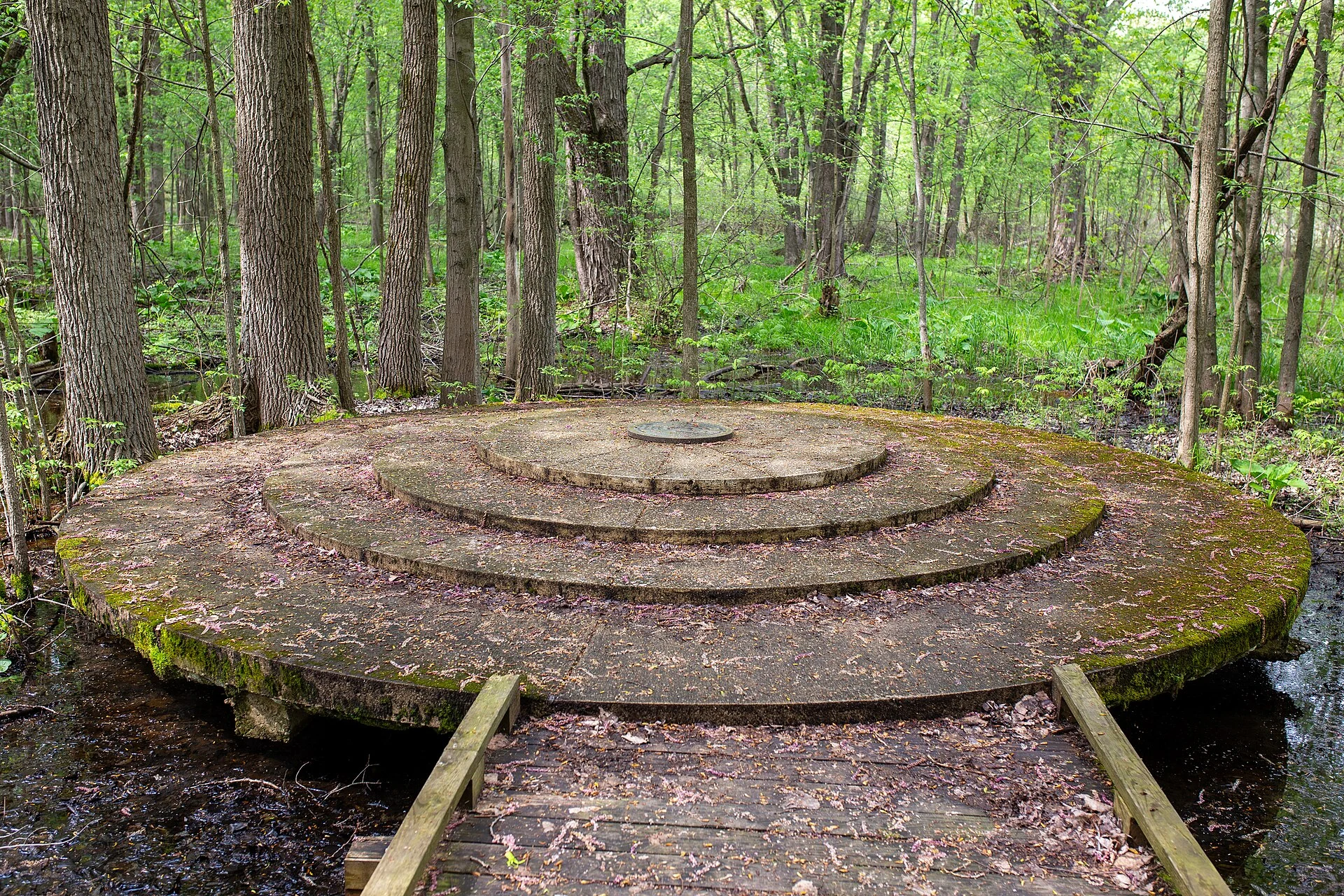
Every property line, every township boundary, every section corner, every legal lot description in the entire state of Michigan traces its origin to a single place: the intersection of the Michigan Meridian and the Baseline, marked by two brass-capped concrete monuments in a quiet, 108-acre woodland on the border of Ingham and Jackson Counties. This is Meridian-Baseline State Park—the most historically significant and least visited park in the Michigan system, the geographic anchor point from which the entire state was literally measured into existence.
Opened to the public on October 12, 2015, after decades of being landlocked and inaccessible on private land, the park preserves Michigan’s “Initial Point”—or more precisely, its two initial points, because Michigan is the only state in the United States that uses a double initial point for its public land surveys, the result of a fascinating 19th-century surveying error that could not be corrected without invalidating thousands of existing property descriptions.
The Double Initial Point: America’s Only
In 1815, surveyor Benjamin Hough established the Michigan Meridian—a north-south line running from the mouth of the Auglaize River at Fort Defiance, Ohio, northward through Michigan. When the Baseline (an east-west line) was surveyed to intersect this meridian, the initial point was established as the origin from which all of Michigan’s townships, ranges, and sections would be measured.
There was a problem: a surveying error. In 1824, surveyor Joseph Wampler discovered the discrepancy and established a corrected baseline corner 935.88 feet (14.18 chains) south of the original marker. Rather than invalidating all the surveys already completed based on the original point, Michigan adopted a unique solution: use the northern (original) marker as the reference for all land east of the meridian, and the southern (corrected) marker for all land west of the meridian.
The result: Michigan is the only state in the Union with two initial points, separated by exactly 935.88 feet along the same north-south meridian line. Both points are preserved in the park, marked by large concrete monuments with commemorative brass plates installed by the Michigan Society of Professional Surveyors in the 1970s.
The Trail (1.5 Miles Round Trip)
A 1.5-mile round-trip trail leads visitors through woodland and across boardwalks to the two monuments. The walk is gentle, mostly flat, and takes approximately 30–45 minutes. Along the way, interpretive signage explains the history of the survey, the significance of the initial points, and the lasting impact of the Public Land Survey System on Michigan’s geography, property law, and settlement patterns.
Why This Matters
The Public Land Survey System (PLSS) is one of the most consequential but least visible infrastructure achievements in American history. Beginning after the Revolutionary War, surveyors systematically divided the western territories into the grid of townships, ranges, and sections that still defines property boundaries, road alignments, county lines, and our fundamental understanding of North American geography. Every “section road” running at one-mile intervals across the Midwest, every 640-acre square section visible from an airplane window, every township and range description in a property deed—all of these trace their origin to initial points like the one preserved at Meridian-Baseline State Park.
Practical Information
- Size: 108 acres
- Trail: 1.5-mile round trip through woodland with boardwalks
- Facilities: Parking area and trail. No camping, no restrooms, no water.
- Accessibility: The trail includes boardwalk sections but may not be fully accessible for all mobility devices
- Best For: History enthusiasts, surveyors, geography buffs, and anyone curious about the invisible infrastructure that shapes American land
- Duration: Allow 30–60 minutes
- Fees: Michigan Recreation Passport required
Frequently Asked Questions
Why does Michigan have two initial points? A 19th-century surveying error resulted in two baseline corners 935.88 feet apart. Rather than invalidate existing surveys, Michigan uses the northern point for land east of the meridian and the southern point for land west of the meridian—the only state in the U.S. with this arrangement.
What is the Public Land Survey System? The PLSS is the method by which the United States government surveyed and divided public domain lands (most of the country west of the original 13 colonies) into the grid of townships, ranges, and sections that still defines property boundaries today.
Is there camping? No. This is a day-use historical site with a walking trail. No camping, restrooms, or water facilities.
Why was the park inaccessible for so long? The initial points were located on landlocked private property for many years. In 2014, the Michigan DNR acquired surrounding land, built a parking lot and trail, and opened the park to the public on October 12, 2015.
Wildlife & Nature
Meridian-Baseline SP — in Ingham County near Lansing — marks the geographic reference point for Michigan’s land survey system. The park’s wetlands and woodlands support songbirds, white-tailed deer, and rabbits. Woodpeckers drum the trees. Cardinals nest in the understory.
Nearby Attractions
Lansing — adjacent — has the Michigan State Capitol and Michigan History Museum. East Lansing — adjacent — has Michigan State University. Sleepy Hollow SP — 15 miles north.
Make it a road trip: Pair a visit with Waterloo Recreation Area (a short drive away) or Mike Levine Lakelands Trail State Park (within about an hour’s drive).

Park Location
Plan your gear for Meridian-Baseline State Park
From our editorial guides, matched to this park’s activities:


Top Tours & Activities Near Kalamazoo
 from $15
 from $29
 from $50