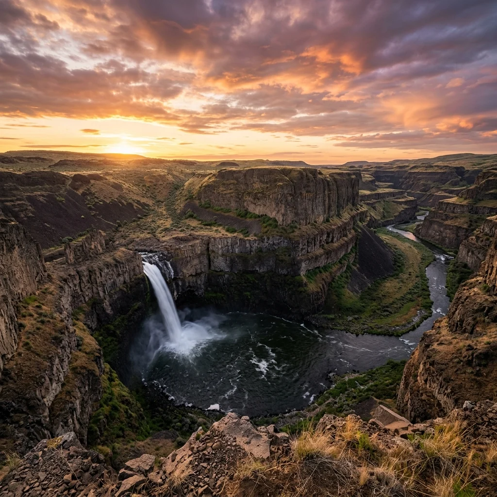
🌊 Washington’s Official State Waterfall — 200-foot plunge into an Ice Age canyon, basalt columns, desert steppe landscape, and one of the most dramatic waterfalls in the Pacific Northwest
In the wheat-field country of southeastern Washington — hours from any mountain, any forest, any city of note — the Palouse River reaches the edge of a basalt canyon and drops 200 feet into a churning pool at the bottom of a gorge carved by the catastrophic Ice Age floods more than 13,000 years ago. Palouse Falls is Washington’s official state waterfall, and it is one of the most visually stunning waterfalls in the American West: a massive column of water plunging over a horseshoe-shaped basalt rim into a canyon of columnar basalt that looks like it belongs on another planet.
Getting to Palouse Falls requires a drive through empty, rolling steppe country on roads that feel like the edge of civilization. The park is remote, minimally developed, and dramatic beyond proportion to its facilities. There is a parking lot, a few viewpoints, pit toilets, and one of the most astonishing views in the Pacific Northwest. That contrast — between the modest infrastructure and the overwhelming geology — is part of what makes Palouse Falls unforgettable.
What to Do at Palouse Falls
1. View the Falls from the Main Overlook
The primary viewing area is a paved, ADA-accessible interpretive path that leads from the parking lot to the Fryxell Overlook. The overlook provides a panoramic view of the 200-foot falls, the horseshoe canyon, and the columnar basalt formations that form the canyon walls. Interpretive panels explain the geological story: how the Missoula Floods — catastrophic glacial floods that occurred between 15,000 and 13,000 years ago — carved this canyon and dozens of others across eastern Washington in events of almost incomprehensible scale.
2. Photograph the Falls
Palouse Falls is one of the most photographed waterfalls in the Northwest. The classic shot captures the falls framed by the horseshoe canyon with columnar basalt walls rising on both sides. Golden hour (sunrise and sunset) creates the most dramatic light, with the basalt walls glowing warm orange against the white water. Star photography is exceptional here — the remote location produces dark skies with minimal light pollution. Bring a tripod and wide-angle lens.
3. Understand the Ice Age Floods
The canyon at Palouse Falls is a product of the Missoula Floods — one of the most dramatic geological events in North America’s recent history. When a glacial ice dam in Montana broke repeatedly between 15,000 and 13,000 years ago, floodwaters carrying the equivalent of half the volume of Lake Michigan raced across eastern Washington at up to 65 mph, carving the channeled scablands, coulees, and canyons that define the region. Palouse Falls is a remnant of that era — the Palouse River was rerouted into a new canyon carved by the floods.
Visitor Information
| Detail | Info |
|---|---|
| Falls Height | ~200 feet (61 m) |
| Hours | 6:30 AM – dusk |
| Entry Fee | WA Discover Pass ($10/day or $30/year) |
| Facilities | Pit toilets, picnic tables, paved overlook |
| Camping | Very limited / check current status |
| Accessibility | Paved path to main overlook is ADA accessible |
| Location | Highway 261, near Washtucna, WA |
| Access Road | Paved + gravel final stretch; limited parking |
Palouse Falls was designated Washington’s official state waterfall in 2014. The park is remote — located 70 miles south of Spokane and 60 miles northeast of the Tri-Cities. The nearest services are in the town of Washtucna (20 minutes). The park has a small primitive campground with 10 sites (no hookups, vault toilets), a Discover Pass ($30/year or $10/day) is required for vehicle access. Cell service is extremely limited. The Milky Way is spectacular on moonless nights due to minimal light pollution. Allow at least 2 hours for the visit, more for photography enthusiasts.
⚠️ Critical Safety Warning
All trails to the canyon floor and base of the falls are permanently closed. The basalt cliffs are unstable, and multiple fatal accidents have occurred when visitors left designated viewing areas. The fenced overlooks provide excellent views. Do not cross any barriers. The canyon is vertical, the rock is loose, and rescue is extremely difficult in this remote location.
Best Time to Visit
| Season | Weather | Water Flow | Best For |
|---|---|---|---|
| Spring (Apr–Jun) | 55–80°F | Peak | Maximum volume, wildflowers on steppe |
| Summer (Jul–Aug) | 85–105°F | Reduced | Longest days, golden light, very hot |
| Fall (Sep–Nov) | 40–70°F | Low | Comfortable temps, golden steppe |
| Winter (Dec–Mar) | 25–45°F | Moderate | Possible ice, road may be difficult |
💰 Trip Cost Estimator
| Expense | Cost | Notes |
|---|---|---|
| Discover Pass | $10 (day) / $30 (annual) | Required for vehicle |
| Gas | $20–40 | Remote location; plan for distance |
| Food | $15–25 | Pack food — no services at park |
| Total (Day Trip) | $45–75 | Family of 4 from Tri-Cities |
Nearby Attractions
Lyons Ferry State Park (15 min north) provides camping, swimming, and boat access where the Palouse and Snake Rivers meet. The Channeled Scablands — the entire landscape of eastern Washington carved by Ice Age floods — extend in every direction and can be explored on a driving loop through Washtucna, Othello, and the Drumheller Channels. Tri-Cities (1.5 hours southwest) is the nearest city with full services, hotels, and restaurants.
Frequently Asked Questions
Can I hike to the base of the falls?
No — all trails to the canyon floor are permanently closed due to fatal accidents. The designated overlooks provide excellent views and are the only legal viewing areas.
How remote is this park?
Very remote. The nearest town (Washtucna) has minimal services. The nearest full-service city (Tri-Cities) is about 90 minutes away. Bring food, water, and a full tank of gas.
Is it worth the drive?
If you appreciate dramatic geology, absolutely. Palouse Falls is one of the most visually stunning waterfalls in the western United States, and the surrounding Ice Age Floods landscape is unlike anything else in the country.
When is the best water flow?
Spring (April–June) delivers the highest water volume from snowmelt. By late summer, the flow can be significantly reduced.
Make it a road trip: Pair a visit with Lyons Ferry State Park (a short drive away) or Central Ferry Park (within about an hour’s drive).
🌊 Ready for Washington’s Most Dramatic Waterfall?
200 feet of raw power plunging into an Ice Age canyon. Columnar basalt walls. Empty steppe stretching to the horizon. Palouse Falls is the wild side of Washington — no forest, no mountain, just geology at its most overwhelming.
What is a Washington Discover Pass?
The Discover Pass ($30/year or $10/day) is required for vehicle access to all Washington state parks and recreation lands. It can be purchased online, at park entrance stations, or at licensed vendors.
What is the most visited state park in Washington?
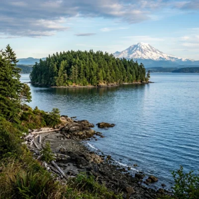
Deception Pass State Park on Whidbey Island is the most visited state park in Washington, famous for its dramatic bridge spanning the narrow gorge and stunning views of Puget Sound and the San Juan Islands.
Can I camp on the San Juan Islands?
Yes, several San Juan Islands parks offer camping, including Moran State Park on Orcas Island and Spencer Spit on Lopez Island. Accessible only by Washington State Ferries — book ferry reservations early in summer.
What is the best time to visit Washington state parks?
June through September offers the driest conditions west of the Cascades. The coast can be enjoyed year-round (winter storm watching is popular). Always carry rain gear when visiting parks west of the Cascades.
The Last Active Waterfall of the Ice Age Floods
Palouse Falls is the dramatic remnant of the Missoula Floods — one of the most catastrophic geological events in Earth’s recent history. Approximately 15,000 years ago, the glacial Lake Missoula burst through its ice dam repeatedly, releasing floodwaters estimated at 10 times the combined flow of all the world’s rivers. These cataclysmic floods carved the channeled scablands of eastern Washington, and Palouse Falls marks one of the locations where the floodwaters carved a new canyon and redirected the course of the Palouse River. The 198-foot waterfall plunges into a deep plunge pool surrounded by columnar basalt cliffs that formed from ancient lava flows of the Columbia River Basalt Group, deposited between 6 and 17 million years ago. The hexagonal basalt columns — some reaching 200 feet in height — create a geometric backdrop that photographers find endlessly compelling.
Hiking and Viewpoints
The park offers several viewing areas accessible from the parking lot. The primary overlook provides a head-on view of the falls from across the canyon. An unofficial but well-worn trail (use extreme caution) leads to the canyon rim above the falls for a dramatic top-down perspective. The cliffs are unfenced in many areas, and the basalt edges can be crumbly and dangerous — stay well back from the edge. The trail to the lower viewpoint descends partway into the canyon for a closer view of the plunge pool and the basalt columns. Spring (March through May) offers the most dramatic water flow as snowmelt feeds the Palouse River, and the surrounding wheat fields create a vivid green contrast against the black basalt.
Photography and Seasonal Conditions
Palouse Falls is one of the most photographed waterfalls in the Pacific Northwest, owing to its dramatic basalt setting and the open landscape that allows multiple composition angles. The golden hour before sunset creates the most dramatic light, when the west-facing canyon walls glow orange against the deepening blue of the plunge pool. Long-exposure photography during moderate flow reveals silken water textures against the geometric basalt columns. Spring (March through May) offers peak water flow and the most dramatic cascade, with the surrounding wheat fields providing vivid green foreground elements. Summer reduces the flow significantly but provides the warmest conditions for extended canyon exploration. Fall brings golden wheat stubble to the surrounding plateau, while winter can create ice formations around the falls edges — though road access may be challenging during snow events. Astrophotography is exceptional here year-round; the Milky Way core is visible from April through October, and the basalt formations create compelling foreground silhouettes against the star field.
Explore More Washington State Parks
Palouse Falls State Park is one of many outstanding state parks in Washington. Discover more parks in our Best State Parks in Washington guide, or use our Park Finder to search by activity, location, or features.
Wildlife & Nature
Palouse Falls SP — features Palouse Falls — a 198-foot waterfall — Washington’s official state waterfall. Carved during the Ice Age Missoula Floods (~13,000 years ago). The park’s basalt canyon, falls, and sagebrush steppe support golden eagles, chukar, and rattlesnakes.

🐾 Dogs & Pets at Palouse Falls State Park
- Pets allowed? statewide rule
- Pets are allowed in most Washington state parks but must be under physical control on a leash at all times.
- Leash rule statewide rule
- 8 ft maximum leash required; pets must be under physical control
- Beaches & swim areas statewide rule
- Pets are not permitted on designated swim beaches
- Cabins & lodging statewide rule
- Pets are not allowed inside vacation houses but are permitted in designated pet-friendly cabins and yurts (e.g. Cape Disappointment, Grayland Beach, Seaquest, Ike Kinswa), typically up to two pets, with a pet fee
- Pet fees statewide rule
- No day-use pet fee; $15 per night pet fee in pet-friendly cabins/yurts
- Statewide exceptions statewide rule
- Director-designated off-leash areas are exempt from the leash rule and are conspicuously posted
Are dogs allowed at Palouse Falls State Park?
Pets are allowed in most Washington state parks but must be under physical control on a leash at all times. Individual parks can post stricter rules — check signage on arrival.
Rules verified July 2026 via parks.wa.gov. More: Washington state parks guide · Dog rules in all 50 states compared
Park Location
Plan your gear for Palouse Falls State Park
From our editorial guides, matched to this park’s activities: