
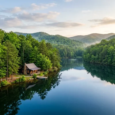
Where a Thousand-Foot Gorge Hides in the Heart of North Georgia’s Blue Ridge
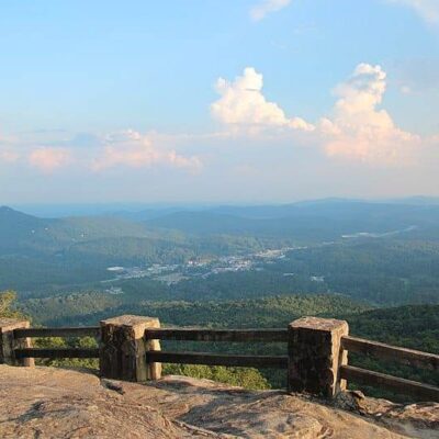
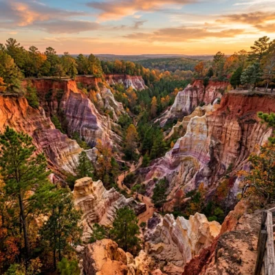
Tallulah Gorge State Park protects one of the most spectacular and deeply dramatic geological features in the eastern United States — a nearly 1,000-foot-deep gorge carved by the Tallulah River through billion-year-old quartzite and gneiss in the Blue Ridge Mountains of northeast Georgia, creating a chasm two miles long, frighteningly narrow, and so deeply cut into the ancient Appalachian bedrock that standing on the rim and looking straight down produces a genuine, visceral, stomach-dropping sensation of vertigo that few landscapes east of the Grand Canyon can match. This is not a gentle river valley gradually widening over millennia — this is a true gorge, with near-vertical walls of blinding white and orange quartzite, a series of six thundering waterfalls visible from rim overlooks, a swaying suspension bridge 80 feet above the churning river, and a gorge floor trail so steep that it descends over 1,100 metal and stone steps to the bottom — where only 100 permitted visitors per day are allowed to stand.
Tallulah Gorge is one of the deepest canyons east of the Mississippi River — a geological feature more typically associated with the sandstone deserts of Utah or the volcanic basalt of the Pacific Northwest than the forested, humidity-draped mountains of Georgia. Yet here it is, hidden in the lush green folds of the southern Appalachians — its existence a testament to the extraordinary erosive power of water working over hundreds of millions of years on some of the oldest, hardest, and most stubbornly resistant rock on the entire continent. The rock at the bottom of Tallulah Gorge formed over a billion years ago — long before the first multicellular organism existed, long before the supercontinent Pangaea assembled and broke apart, longer ago than the human mind can meaningfully comprehend.
The Suspension Bridge: 80 Feet Above the Abyss
The gorge’s most thrilling feature — and the moment most visitors remember long after leaving — is the suspension bridge that spans the narrowest section of the canyon, swaying gently but unmistakably 80 feet above the rocky riverbed and the churning whitewater of Hurricane Falls below. Crossing the bridge engages every primal instinct simultaneously: the metal grating beneath your feet reveals the full depth of the drop with each step, the bridge sways rhythmically with your movement and with every gust of mountain wind funneling through the gorge, and the views upstream and downstream into the dark, wet, echoing corridor of rock are simultaneously spectacular and terrifying.
The bridge provides the single best vantage point for viewing Hurricane Falls, which drops in a dramatic, narrowing cascade directly beneath the span — so close that spray mists your face on high-water days. After heavy rains or during Georgia Power’s scheduled water releases, the volume of water pouring through the gorge transforms Hurricane Falls from a silvery, photogenic thread into a thundering wall of whitewater whose roar reverberates off the billion-year-old canyon walls with a bass vibration you feel in your ribcage more than you hear with your ears. Even the bridge itself vibrates faintly with the force of the water below.
The suspension bridge is accessed via the North Rim Trail and is included in the rim trail loop — no gorge floor permit is required to cross it. However, the bridge is closed during lightning storms and during scheduled whitewater release days when water levels make the gorge floor dangerous.
The Gorge Floor Trail: 1,100 Steps to Another World
For adventurous visitors willing to earn their views with sweat and burning quadriceps, the park issues 100 gorge floor permits per day — available on a first-come, first-served basis at the Jane Hurt Yarn Interpretive Center, starting when the center opens at 9:00 a.m. The permit system exists for both safety and conservation: the gorge floor trail is genuinely strenuous, involving the descent (and, crucially, the far more grueling re-ascent) of over 1,100 metal and stone steps on steep staircases bolted to the canyon walls — some sections approaching 45 degrees, with handrails that are less a convenience than a necessity.
Proper footwear is mandatory — the Interpretive Center staff will inspect your shoes and turn away visitors wearing flip-flops, sandals, Crocs, or any inadequate footwear. This is not bureaucratic theater — the metal stairs are frequently wet with spray and condensation, the rocks at the gorge floor are covered in slippery algae and moss, and falls on this trail range from unpleasant to life-threatening. Wear hiking boots or sturdy trail shoes with aggressive tread.
The effort is profoundly, unforgettably rewarding. The gorge floor is an entirely different world from the rim — cooler by 10–15°F even in summer, darker, and dominated by the sound of rushing water echoing off billion-year-old rock walls that rise hundreds of feet on either side, blocking direct sunlight for much of the day. You’ll cross the suspension bridge, scramble over house-sized boulders at the water’s edge, and experience the gorge at a scale and intimacy that rim overlooks simply cannot convey — standing at the base of Hurricane Falls, looking up at nearly 1,000 feet of vertical quartzite, feeling the spray on your face and the bass vibration of falling water resonating in your chest like a second heartbeat. The acoustics are extraordinary — the gorge walls amplify and distort every sound, creating an immersive audio environment as dramatic as the visual one.
Budget 2–3 hours minimum for the gorge floor experience. The descent takes 30–45 minutes; the re-ascent, against gravity and usually against depleted enthusiasm, takes 45–90 minutes depending on fitness. Bring at least two liters of water per person, snacks, and a headlamp as a precaution. Gorge floor permits are not available on scheduled whitewater release days, when Georgia Power releases water from the Tallulah Falls Dam upstream, transforming the normally manageable river into a Class IV–V whitewater torrent.
Six Waterfalls in Two Miles
The Tallulah River drops approximately 500 vertical feet through a series of six named waterfalls within the two-mile gorge — a concentrated waterfall corridor unmatched in the southeastern United States. L’Eau d’Or Falls (the “Water of Gold”) is the first and most elegant, a 56-foot cascade visible from the uppermost overlook. Tempesta Falls (76 feet) plunges through a narrow slot in the quartzite. Hurricane Falls (96 feet) is the most photographed, dropping dramatically beneath the suspension bridge. Oceana Falls, Bridal Veil Falls, and Sweet Sixteen Falls continue the descent through increasingly dramatic and narrow canyon sections visible only from the gorge floor or specific rim angles.
The waterfalls’ volume varies dramatically with rainfall and dam releases. After sustained rain, all six falls run heavy and white, filling the gorge with spray and thunder. During dry periods, some falls thin to delicate ribbons — still beautiful, but utterly different in character. The scheduled aesthetic water releases (typically two weekends in spring and two in fall) temporarily restore the waterfalls to something approaching their magnificent pre-dam volume.
Rim Trails and Overlooks: The View from Above
For visitors who prefer to admire the gorge from above — or who arrive too late to secure one of the 100 daily gorge floor permits — the park maintains excellent rim trails on both sides of the canyon with ten numbered overlooks providing different angles, depths, and perspectives:
North Rim Trail (2 miles round trip): Features five overlooks (numbered 1–5) that trace the gorge’s edge and provide increasingly dramatic views of the waterfalls, the suspension bridge spanning the abyss, and the full staggering depth of the canyon. Overlook 2 offers the most viscerally dramatic straight-down view into the gorge’s narrowest section, where the walls compress to mere feet apart and the river is a white thread hundreds of feet below. Overlook 5 provides a panoramic view of the entire gorge corridor. Moderate difficulty with some stair sections and uneven terrain.
South Rim Trail: Connects to additional overlooks (numbered 6–10) providing contrasting perspectives of the waterfalls, canyon walls, and the dense hemlock and rhododendron forest that clings to the gorge rim. Overlook 7 provides the best viewing angle for L’Eau d’Or Falls. The combination of North and South Rim trails creates a comprehensive 3.5-mile gorge experience without the intensity of the floor descent — and without requiring a permit.
Shortline Trail: A paved, fully accessible trail following a historic logging railroad bed — suitable for strollers, wheelchairs, and bicycles. The trail offers filtered gorge views through the forest canopy and connects to the park’s beach and lake area. Perfect for families with small children or visitors with mobility limitations who still want to experience the park’s atmosphere.
Stoneplace Trail (10 miles): A challenging backcountry loop for serious hikers and mountain bikers, traversing the forested ridges above the gorge with occasional stunning views into the canyon. This trail sees a fraction of the rim trails’ traffic and offers genuine Blue Ridge Mountain forest solitude.
History: Tightropes, Resort Hotels, and a Dam That Changed Everything
Tallulah Gorge has drawn visitors, tourists, and daredevils since before the Civil War. In the late 1800s, Tallulah Falls was one of the most popular tourist destinations in the entire southern Appalachians — a summer resort destination rivaling Niagara Falls in name recognition, with grand hotels lining the gorge rim, a railroad bringing tourists from Atlanta and beyond, and the thundering waterfalls visible from hotel porches and manicured garden overlooks. At its peak, the Tallulah Falls resort community drew tens of thousands of visitors annually.
The construction of the Georgia Railway & Power Company’s Tallulah Falls Dam in 1913 — one of the largest hydroelectric projects of its era — dramatically and permanently reduced water flow through the gorge, diminishing the once-thundering waterfalls to shadows of their former selves and eventually contributing to the decline and eventual disappearance of the resort hotels. The dam was controversial from its inception — conservationist Helen Dortch Longstreet (widow of Confederate General James Longstreet) led one of the first organized environmental opposition movements in Georgia’s history, but ultimately lost to the political and economic power of the utility company. The tension between hydropower development and natural preservation at Tallulah Gorge prefigured similar battles at Hetch Hetchy, the Colorado River, and countless other sites throughout the 20th century.
The gorge gained its most extraordinary moment of international fame on July 18, 1970, when legendary high-wire artist Karl Wallenda — 65-year-old patriarch of the Flying Wallendas circus family — walked across Tallulah Gorge on a steel cable strung 750 feet above the river, performing two headstands during the 1,000-foot crossing while an estimated 30,000 spectators lined both rims of the gorge. The walk took 18 minutes. The steel support towers from Wallenda’s wire are still visible from several park overlooks — rusted monuments to an era of spectacle and human daring that seems almost inconceivable by modern safety standards. Wallenda would die eight years later, falling from a wire stretched between two hotels in San Juan, Puerto Rico.
Geology: A Billion Years of Appalachian History Laid Bare
The rock exposed in Tallulah Gorge is among the oldest visible on Earth’s surface — Precambrian gneiss and quartzite over one billion years old, metamorphosed from even older sedimentary rocks during ancient mountain-building events (orogenies) that predate the current Appalachian range by hundreds of millions of years. These rocks formed during the Grenville Orogeny — an immense collision of tectonic plates that created a mountain range potentially rivaling the modern Himalayas in height, then gradually eroded to near-flatness before the Appalachians themselves rose from subsequent collisions hundreds of millions of years later.
The gorge itself was carved by the Tallulah River over tens of millions of years, exploiting fracture zones and fault lines in the extremely hard metamorphic rock to cut progressively deeper while the surrounding landscape eroded more slowly. The gorge’s remarkable depth and narrowness — its defining visual characteristics — are direct products of the rock’s exceptional hardness: softer rock would have eroded laterally into a wider, shallower valley, but the quartzite and gneiss resisted lateral erosion while the river’s persistent vertical cutting created the narrow, cliff-walled chasm visible today. The six waterfalls within the gorge mark specific fault lines and ledges of particularly resistant rock that create steps in the river’s longitudinal profile — natural obstacles that the river has been slowly, relentlessly eroding for millions of years and will eventually, inevitably, eliminate entirely.
Visitor Guide: Planning Your Tallulah Gorge Adventure
Getting There
Tallulah Gorge State Park is located directly on US-441 in the town of Tallulah Falls, Georgia — approximately 95 miles (2 hours) northeast of Atlanta and 20 miles south of Clayton, GA, in the heart of the north Georgia Blue Ridge Mountains. The park is easily accessible from Atlanta via I-985 North to US-23/441. It lies along the main corridor between Atlanta and the western North Carolina mountains, making it an excellent stop en route to Highlands, Cashiers, or the Great Smoky Mountains.
Fees and Hours
Parking is $5 per vehicle. The park is open daily year-round from 8:00 a.m. to dark. The Jane Hurt Yarn Interpretive Center — the starting point for all park information, maps, orientation, and gorge floor permits — is open 9:00 a.m. to 5:00 p.m. Gorge floor permits (100/day) are free but strictly first-come, first-served. On weekends, holidays, and during peak fall foliage season (typically mid-October to early November), arrive before the Interpretive Center opens at 9:00 a.m. to ensure a permit — they can sell out within the first hour on busy days.
Best Times to Visit
Fall (October – November): The gorge rim blazes with Appalachian autumn color — sugar maples, hickories, sourwoods, and oaks in reds, oranges, and golds framing the grey-white quartzite walls — making this the most photogenic and most visited season. The annual November gorge run and fall water releases add to the atmosphere. Spring (March – May): Wildflowers carpet the forest floor, mountain laurel and rhododendron bloom on the gorge rim, and spring rains push all six waterfalls to their most dramatic volumes. Summer (June – August): Warm and humid but intensely green; the gorge floor provides natural air conditioning, and the park’s 63-acre lake offers swimming at the beach. Winter (December – February): Cool, quiet, and atmospheric, with bare deciduous trees revealing dramatically more of the gorge structure than leafy summer canopy allows — serious photographers often prefer this understated, skeletal beauty.
Camping and Accommodations
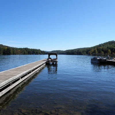
The park offers 50 tent and RV campsites ($28–$40/night) in a forested campground with electric/water hookups, flush toilets, and hot showers. A pioneer campground provides a more primitive experience. The 63-acre Tallulah Lake features a swimming beach (seasonal), a children’s playground, and fishing access. The nearby mountain towns of Tallulah Falls and Clayton provide restaurants, outfitters, bed-and-breakfast inns, and vacation cabin rentals that serve as excellent base camps for multiday Blue Ridge explorations.
💒 Elopements at Tallulah Gorge
A 1,000-foot-deep gorge with a suspension bridge, cascading waterfalls, and dramatic rock formations — Tallulah Gorge offers some of the most extreme landscape drama for elopements in the Southeast. The rim overlooks provide canyon-edge ceremony settings with the gorge plunging below.
A permit is required through Georgia State Parks. The park allows limited daily access to the gorge floor (by permit), but rim-top overlooks are accessible without the gorge permit. Entry requires a $5 parking fee per vehicle.
Read our complete State Park Wedding Planning Guide for Georgia elopement options.
Frequently Asked Questions
How do I get a gorge floor permit?
Permits are issued on a first-come, first-served basis at the Jane Hurt Yarn Interpretive Center starting at 9:00 a.m. — no advance reservations are possible. Only 100 permits are available per day, and they are not issued on scheduled whitewater release days. On fall weekends and holidays, arrive before 9:00 a.m. to join the permit line — permits can sell out within the first hour. Your shoes will be inspected; inadequate footwear means no permit. You must complete all 1,100 steps in both directions — there is no shortcut or easier exit.
Is the suspension bridge scary?
That depends entirely on your relationship with heights and your definition of “scary.” The bridge is safe and well-maintained, inspected regularly, and designed to handle far more weight than it ever carries. But it does sway noticeably and deliberately — suspension bridges are designed to move — the grated metal floor reveals the 80-foot drop to the churning river below with every step, and the views in both directions into the dark, narrow, plunging gorge walls are genuinely vertigo-inducing. Most visitors cross without issue and describe it as thrilling rather than frightening. Those with severe acrophobia may find it deeply challenging.
Can I kayak through the gorge?
Only during scheduled whitewater release dates — typically 4–6 weekends per year, primarily in April and November. The rapids during releases are Class IV–V and are emphatically suitable only for expert paddlers with significant whitewater experience. Boaters must carry their craft down (and back up) the same 1,100 gorge stairs. Check gastateparks.org or call the park directly for the current release schedule.
Are dogs allowed?
Dogs on leash (maximum 6 feet) are welcome on all rim trails and the Shortline Trail. Pets are not permitted on the gorge floor trail, the Hurricane Falls staircase, or the Sliding Rock swimming area — the steep, narrow stairs and scrambling sections are genuinely unsafe for most dogs, and the gorge floor environment is too sensitive for uncontrolled pet access.
How does Tallulah Gorge compare to other eastern canyons?
Tallulah Gorge is among the two or three deepest canyons in the eastern United States, comparable in depth to Linville Gorge (NC) and the New River Gorge (WV). Its combination of extreme depth, dramatic narrowness, six consecutive waterfalls, a swaying suspension bridge, and the extraordinary 1,100-step gorge floor descent makes it unique among eastern canyons — no other offers quite this combination of geological drama, physical adventure, and accessibility. The gorge floor permit system adds an element of exclusivity — standing at the bottom of Tallulah Gorge is an experience shared by only 100 people per day in a world of 8 billion.
What activities are available at this state park?
Common activities include hiking, camping, fishing, swimming, picnicking, and wildlife watching. Check the park website for specific offerings, trail maps, and seasonal programs.
Do I need a reservation to camp?
Reservations are recommended for camping, especially on weekends and holidays during peak season. Most state park systems offer online reservation portals where you can book sites months in advance.
Are dogs allowed at this state park?
Dogs are typically allowed in campgrounds and on most trails but must be kept on a leash (usually 6 feet). Dogs are often prohibited at swimming beaches. Service animals are always welcome. Check specific park rules.
What is the best time to visit?
Spring and fall generally offer the most comfortable weather for outdoor activities. Summer is peak for swimming and camping. Check the specific park for seasonal closures and optimal visiting conditions.
Explore More Georgia State Parks
Tallulah Gorge State Park is one of many outstanding state parks in Georgia. Discover more parks in our Best State Parks in Georgia guide, or use our Park Finder to search by activity, location, or features.
Make it a road trip: Pair a visit with Traveler’s Rest State Historic Site (a short drive away) or Black Rock Mountain State Park (a short drive away).

Park Location
Plan your gear for Tallulah Gorge State Park
From our editorial guides, matched to this park’s activities:

Top Tours & Activities Near Blue Ridge
 from $31
 from $20
 from $31