💧 Tennessee’s Hidden Masterpiece — A 110-foot waterfall that emerges from a cave and vanishes into a sinkhole, 9-mile wilderness hike through Cumberland Plateau gorges, and 4 waterfalls on one trail
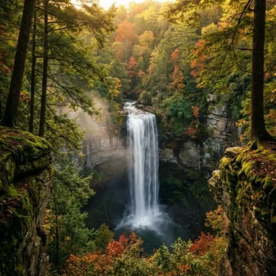
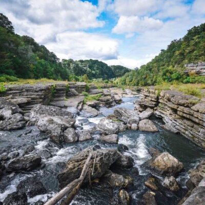
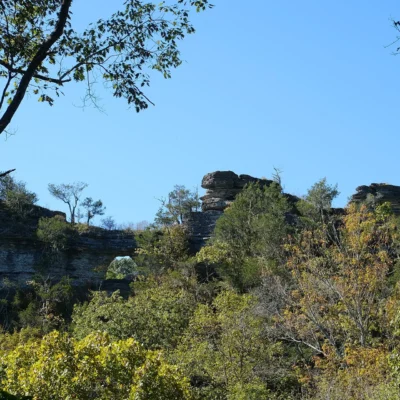
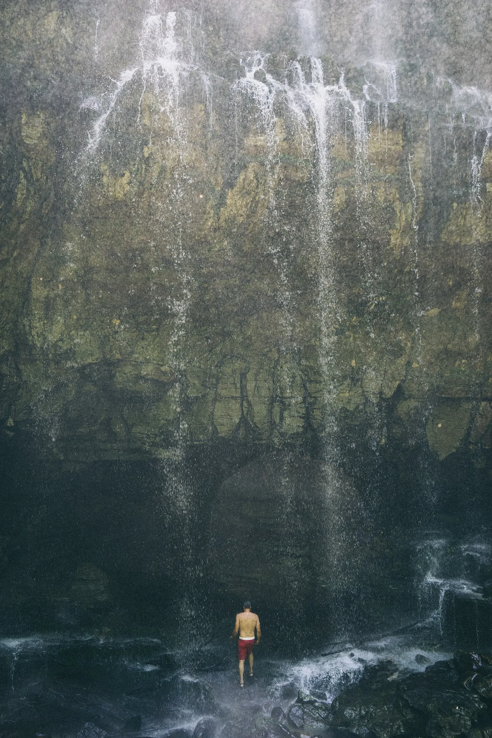
Deep in the Cumberland Plateau of middle Tennessee, a creek emerges from the mouth of a cave, falls 110 feet over a sandstone cliff, and disappears into a sinkhole at the bottom — never reaching a river, never flowing above ground again. Virgin Falls is one of the most extraordinary waterfalls in the eastern United States, and reaching it requires one of Tennessee’s most rewarding hikes: a strenuous 9-mile round-trip trek through old-growth forest, past three other waterfalls, across a cable creek crossing, and along the rim of Scott’s Gulf — a 800-foot-deep gorge that rivals anything in the Appalachians for raw dramatic power.
Virgin Falls State Natural Area protects 1,500 acres of this wild Cumberland Plateau landscape. There are no paved roads to the falls, no visitor center, no gift shop, no cell service. The trailhead is a gravel parking lot at the end of a rural road. What you get instead is one of the finest wilderness day hikes or overnight backpacking trips in Tennessee — a trail that passes four waterfalls, traverses diverse forest ecosystems, offers gorge overlooks that steal your breath, and culminates at a waterfall that defies easy explanation. Water flowing from underground, falling through air, and vanishing back underground — all in one place.
The Trail
Trail Overview
The trail to Virgin Falls is an out-and-back route of approximately 9 miles round trip. The path descends roughly 900 feet from the trailhead to the falls, which means the return hike is almost entirely uphill. The terrain is rocky, rooty, and uneven throughout. This is a strenuous hike that requires proper preparation, good footwear, adequate water, and realistic time management.
| Detail | Info |
|---|---|
| Distance | ~9 mi round trip |
| Elevation Change | ~900 ft descent/ascent |
| Difficulty | Strenuous |
| Time | 5–9 hours (day hike) or overnight |
| Trail Surface | Rocky, rooty, natural surface |
| Creek Crossing | Cable crossing at Big Laurel Creek |
Waterfalls Along the Trail
The trail passes four named waterfalls, making the journey as rewarding as the destination:
| Waterfall | Height | Mile Marker | Notes |
|---|---|---|---|
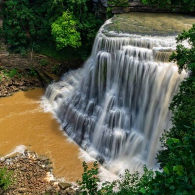
| Big Laurel Falls | ~30 ft | ~1.5 mi | Wide cascade, easy side trail access |
| Sheep Cave Falls | ~40 ft | ~3.0 mi | Falls drop into a cave recess |
| Big Branch Falls | ~25 ft | ~3.5 mi | Mossy cascade in a hemlock grove |
| Virgin Falls | 110 ft | ~4.5 mi | Emerges from cave, drops into sinkhole |
Martha’s Pretty Point
A short side trail leads to Martha’s Pretty Point — a cliff-edge overlook of Scott’s Gulf and the Caney Fork River gorge, 800 feet below. The view is among the most dramatic in Tennessee. If you’re doing the hike as a day trip, you may need to skip this side trip to maintain daylight; for overnight backpackers, it’s a must.
Backpacking & Camping
Virgin Falls is an excellent overnight backpacking destination. Designated campsites are available along the trail, including near the cable crossing and near the main falls. Camping is not permitted above Virgin Falls. Self-registration is required at the trailhead kiosk. This is primitive backcountry camping — no water treatment, no restrooms, no bear boxes. Pack everything in, pack everything out. Leave No Trace principles are essential.
Know Before You Go
Essential Gear
Sturdy hiking boots with ankle support (the trail is rocky and uneven). At least 2–3 liters of water per person. Headlamp (in case you hit the trail later than planned). Trekking poles help significantly on the steep return. In spring and after rain, the creek crossing requires careful foot placement on the cable-assisted ford.
Safety Warnings
Do not attempt the cable crossing during high water. After heavy rain, Big Laurel Creek can become dangerous. Check weather forecasts before going. The cliff edges at Martha’s Pretty Point and along the gorge rim are unfenced and can be slippery. All caves in the natural area are closed to protect bats from White Nose Syndrome. Start early — you need 5–9 hours for the round trip plus stops.
Visitor Information
| Detail | Info |
|---|---|
| Hours | Sunrise to sunset (day use); overnight by self-registration |
| Entry Fee | Free |
| Location | Scotts Gulf Road, near Sparta, TN (White County) |
| Facilities | Gravel parking lot, registration kiosk only |
| Cell Service | None — inform someone of your plans |
| Caves | Closed (White Nose Syndrome protection) |
| Dogs | Allowed (leashed); trail is difficult for dogs |
Best Time to Visit
| Season | Weather | Water Flow | Best For |
|---|---|---|---|
| Spring (Mar–May) | 55–75°F | High | Maximum water volume, wildflowers, lush forest |
| Summer (Jun–Aug) | 75–90°F | Low-Moderate | Longest days, warm (hot on the climb out) |
| Fall (Sep–Nov) | 50–75°F | Low-Moderate | Fall foliage, comfortable hiking temps |
| Winter (Dec–Feb) | 30–50°F | Moderate | Solitude, ice formations (slippery trail) |
💰 Trip Cost Estimator
| Expense | Cost | Notes |
|---|---|---|
| Admission | FREE | No fee, no parking fee |
| Backcountry Camping | FREE | Self-registration at trailhead |
| Gas (from Crossville) | $10–15 | ~30 miles on winding roads |
| Total | $10–15 | One of TN’s best free outdoor experiences |
Nearby Attractions
Ozone Falls (30 min east) — a 110-foot roadside waterfall just off I-40 that makes a perfect warm-up or cooldown to the Virgin Falls hike. Fall Creek Falls State Park (1 hour south) — Tennessee’s most-visited state park with the tallest freefall waterfall east of the Mississippi. Rock Island State Park (30 min south) offers swimming holes, waterfalls, and a more developed park experience. Sparta (20 min) provides lodging, dining, and supplies.
Frequently Asked Questions
How hard is this hike?
Strenuous. The trail is 9 miles round trip with 900 feet of elevation change, rocky terrain, and a creek crossing. The return is almost entirely uphill. Allow 5–9 hours for a day hike.
Can I camp at Virgin Falls?
Yes — there are designated backcountry campsites. Camping is not permitted above the falls. Self-register at the trailhead kiosk. This is primitive camping with no facilities.
What makes Virgin Falls unique?
The waterfall emerges from a cave, falls 110 feet, and disappears into a sinkhole — the water never flows above ground except for this brief, dramatic plunge. It is one of the most geologically unusual waterfalls in North America.
Is there cell service?
No — there is no cell service on the trail or at the trailhead. Tell someone your plans and expected return time before heading out.
Can I swim at Virgin Falls?
The plunge pool is small and rocky, not well-suited for swimming. Big Laurel Falls has a more accessible pool area, though the water is always cold.
More parks nearby: Scott’s Gulf Wilderness State Park is a short drive away, while Fall Creek Falls State Park lies a short drive away.
Camping reservations: Book campsites and cabins for Tennessee state parks online at reserve.tnstateparks.com.
💧 Ready for One of Tennessee’s Greatest Hikes?
A 110-foot waterfall that emerges from a cave and vanishes underground. Four waterfalls. A gorge overlook. Nine miles of real wilderness. Virgin Falls is the Cumberland Plateau at its most magnificent — and it costs nothing to experience.
Wildlife & Nature
Virgin Falls SNA — on the Cumberland Plateau — features a 110-foot waterfall that emerges from a cave, drops through the air, and disappears into another cave — a geological wonder. The 8-mile roundtrip hike also passes Big Laurel Falls and Sheep Cave Falls. Black bears and timber rattlesnakes inhabit the forest.

Park Location
Plan your gear for Virgin Falls State Natural Area
From our editorial guides, matched to this park’s activities: