🌅 The Mountain of Gold — 8,000 Acres of Wild California Coastline with Sea Cliffs, Tide Pools, a 1,347-Foot Summit, and 65 Miles of Trails on Highway 1 — Montaña de Oro State Park near Los Osos and San Luis Obispo, California with Spooner’s Cove beach, Bluff Trail coastal walk, Valencia Peak summit (1,347 ft, 360° views), tide pools at Hazard Canyon Reef, Islay Creek Canyon waterfall, Oats Peak, Coon Creek Trail, 65+ miles of trails, mountain biking, equestrian, primitive camping (47 sites), horse camp, Spooner Ranch House visitor center (est. 1892), wildflowers, Morro Bay nearby, Highway 1 — San Luis Obispo County, California
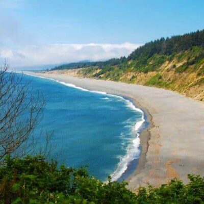
Montaña de Oro means “Mountain of Gold” — named for the golden California poppies and wildflowers that blanket these coastal hills every spring. This is 8,000 acres of wild, undeveloped California coastline: sea cliffs dropping into crashing surf, tide pools filled with ochre sea stars, canyon trails to hidden waterfalls, and a summit with 360-degree views of the Pacific.
No entrance fee. No development. No crowds. Just raw Central Coast beauty between San Luis Obispo and Morro Bay, right off Highway 1.
The Landscape
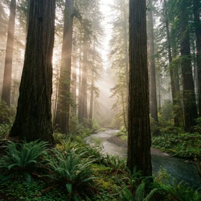
Montaña de Oro sits on the Central California coast between Morro Bay and the Irish Hills. The park stretches from rugged sea cliffs and sandy coves at sea level to chaparral-covered peaks above 1,600 feet — eight distinct habitat zones in one park. The western edge is dramatic rocky coastline. The interior is steep canyons, oak woodlands, and grasslands. And in spring, everything turns gold.
The Trails
With 65+ miles of trails, Montaña de Oro has one of the largest trail networks of any California state park. Hiking, mountain biking, and equestrian — each with dedicated routes.
| Trail | Distance | Difficulty | Highlights |
|---|---|---|---|
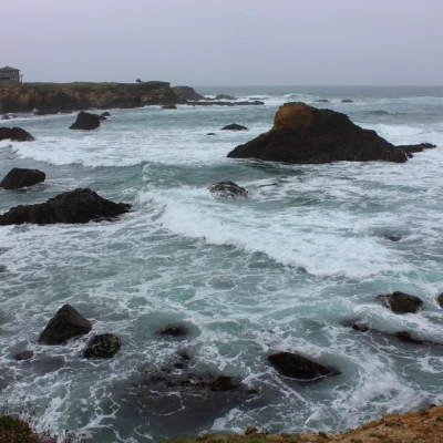
| Bluff Trail | 3.4 mi RT | Easy | Sea cliff coastal walk. Dramatic coves, wave action, tide pool access. Best at sunset |
| Valencia Peak | 4.5 mi RT | Strenuous | Summit at 1,347 ft — 360° panoramic views of Pacific, Morro Bay, Irish Hills. 1,000+ ft gain |
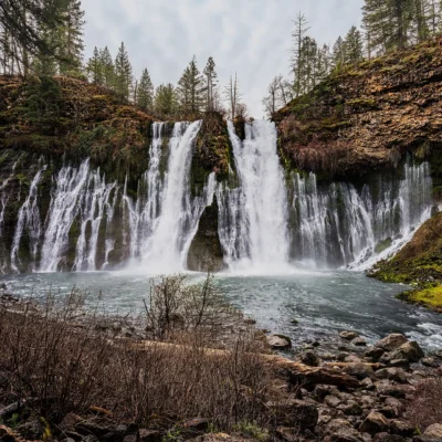
| Islay Creek | 6 mi RT | Easy–Moderate | Gentle canyon hike through oaks to a small waterfall |
| Oats Peak | 10–11 mi RT | Strenuous | Interior ridgeline — expansive views of Irish Hills. 1,400+ ft gain |
| Hazard Peak | 6 mi RT | Moderate | Panoramic Morro Bay views. Popular mountain biking route |
| Coon Creek | 5 mi RT | Easy | Flat riparian canyon — coastal sage scrub, arroyo willows, birding |
| Alan Peak | 12+ mi RT | Strenuous | Via Oats Peak — reaches 1,649 ft. Remote, brushy final stretch |
Mountain Biking & Equestrian
Many trails — including Hazard Peak, Oats Peak, and Islay Creek — are open to mountain bikes and equestrians. The park’s terrain ranges from fast fire roads to technical singletrack. Hazard Canyon Horse Camp provides dedicated equestrian camping.
The Coastline
Spooner’s Cove
The park’s most iconic spot — a sheltered sandy cove at the base of sea cliffs, directly across from the campground. Beachcombing, wading, picnicking. Dogs allowed on-leash on the beach (not on trails). The cove was originally used as a “doghole” shipping port by the Spooner Ranch in the 1890s.
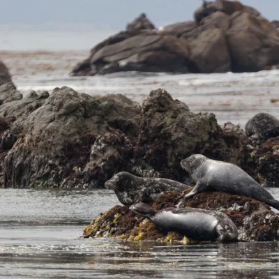
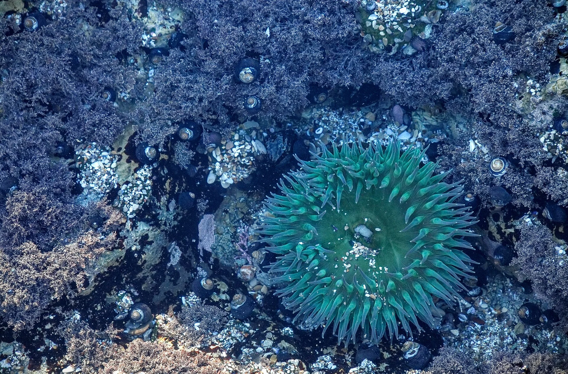
Tide Pools
Some of the best tide pooling on the Central Coast:
| Location | What You’ll See |
|---|---|
| Spooner’s Cove | Anemones, limpets, barnacles — easy access |
| Hazard Canyon Reef | Ochre sea stars (keystone species), crabs, mussels — dramatic reef platform |
The History — Spooner Ranch
| Year | Event |
|---|---|
| 1892 | Alden Spooner Jr. establishes ranch — dairy, farm, and hog operation |
| 1890s | “Doghole” shipping port built at Spooner’s Cove for ranch products |
| Later | Owner Irene McAllister names the area “Montaña de Oro” for the golden wildflowers |
| Today | Spooner Ranch House serves as visitor center, museum, and gift shop |
Camping
| Campground | Sites | Amenities | Notes |
|---|---|---|---|
| Islay Creek | 47 primitive sites | Picnic tables, fire pits, drinking water | Near Spooner’s Cove. Max vehicle 27 ft. No showers |
| Environmental Camps | Secluded walk-in | Primitive — pack in/out | Requires registration |
| Hazard Canyon Horse Camp | Equestrian | Horse facilities | Dedicated equestrian overnight |
Best Time to Visit
| Season | Weather | Best For |
|---|---|---|
| Spring (Mar–May) | 55–70°F | 🌼 The Mountain of Gold — wildflowers peak. Poppies, lupine, golden hills. Best tide pools (low tides). Whale watching |
| Fall (Sep–Nov) | 60–75°F | Clear skies, warm hiking, less coastal fog. Best overall weather |
| Summer (Jun–Aug) | 60–70°F | Coastal fog common mornings, clears by afternoon. Cool compared to inland |
| Winter (Dec–Feb) | 50–60°F | Dramatic surf, gray whale migration, green hills. Rain possible |
Nearby — Morro Bay
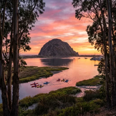
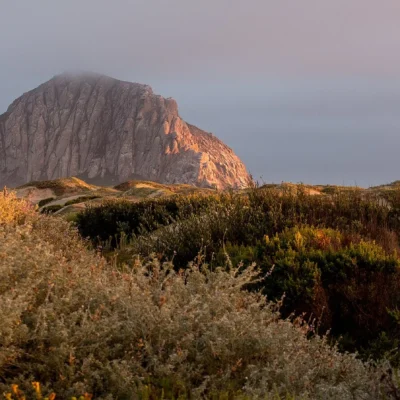
Montaña de Oro sits just 6 miles south of Morro Bay — home to the iconic Morro Rock, a 2,300-acre estuary (one of California’s most important wetlands), and a waterfront town with restaurants, kayak rentals, and the Morro Bay Natural History Museum.
💰 Trip Cost Estimator
| Trip Style | Duration | Total Cost | Includes |
|---|---|---|---|
| Bluff Walk | 1–2 hrs | FREE | Coastal cliffs, Spooner’s Cove, tide pools |
| Day Hike | Full day | FREE | Valencia Peak summit + Bluff Trail + Spooner’s Cove |
| Weekend Camping | 2 nights | $35–$70 | Islay Creek campground + full trail system + coast |
| Mountain Biking | Full day | FREE | Hazard Peak + Oats Peak fire roads |
| Best Value | Full Day | $0 | 65+ miles of trails, 8,000 acres, wild coast — all free |
Frequently Asked Questions
Why is it called Mountain of Gold?
The golden California poppies and wildflowers that blanket the hills each spring. The Spanish name “Montaña de Oro” was given by later ranch owner Irene McAllister. Peak bloom is typically March through May.
Is there an entrance fee?
No — completely free to enter. No parking fee, no day-use fee. One of the best free parks on Highway 1.
Which hike should I do first?
The Bluff Trail for scenery, Valencia Peak for the summit. The 3.4-mile Bluff Trail is easy and dramatic — sea cliffs, coves, wave-carved rocks. Valencia Peak (4.5 mi RT) is strenuous but rewards with 360° Pacific views from 1,347 feet. Do both in a day.
Can I bring my dog?
Dogs on-leash at Spooner’s Cove beach and the campground only. Not allowed on any trails or undeveloped areas.
Are there good tide pools?
Some of the best on the Central Coast. Hazard Canyon Reef has ochre sea stars, anemones, crabs, and mussels on a dramatic reef platform. Check tide charts — best at low tides during spring.
How is the mountain biking?
Excellent — 65+ miles of trails with many open to bikes. Hazard Peak and Oats Peak offer fire-road climbing with Pacific views. The terrain ranges from fast fireroads to technical singletrack.
Can I camp with horses?
Yes — Hazard Canyon Horse Camp has dedicated equestrian facilities. Many trails are also open to horseback riding.
How close is Morro Bay?
About 6 miles north. Morro Rock, estuary kayaking, waterfront dining, and the Natural History Museum are all easy day-trip additions.
What wildlife might I see?
Gray whales (winter), sea otters, raptors, deer, and diverse tide pool life. The park’s eight habitat zones support an extraordinary range of coastal and inland species.
Is it crowded?
Far less crowded than Big Sur or Carmel. Montaña de Oro is one of the Central Coast’s best-kept secrets — 8,000 acres with no entrance fee and no commercial development.
Nearby state parks: If you have extra time, Los Osos Oaks State Natural Reserve is a short drive away, and Morro Bay State Park is a short drive away.
Camping reservations: Book campsites and cabins for California state parks online at reservecalifornia.com.
🌅 The Mountain of Gold — Free Wild California Coast
8,000 acres of sea cliffs, tide pools, canyon waterfalls, golden wildflower hills, and a 1,347-foot summit with Pacific views. 65+ miles of trails for hiking, biking, and riding. No entrance fee. Right on Highway 1.

Park Location
Plan your gear for Montana de Oro State Park
From our editorial guides, matched to this park’s activities: