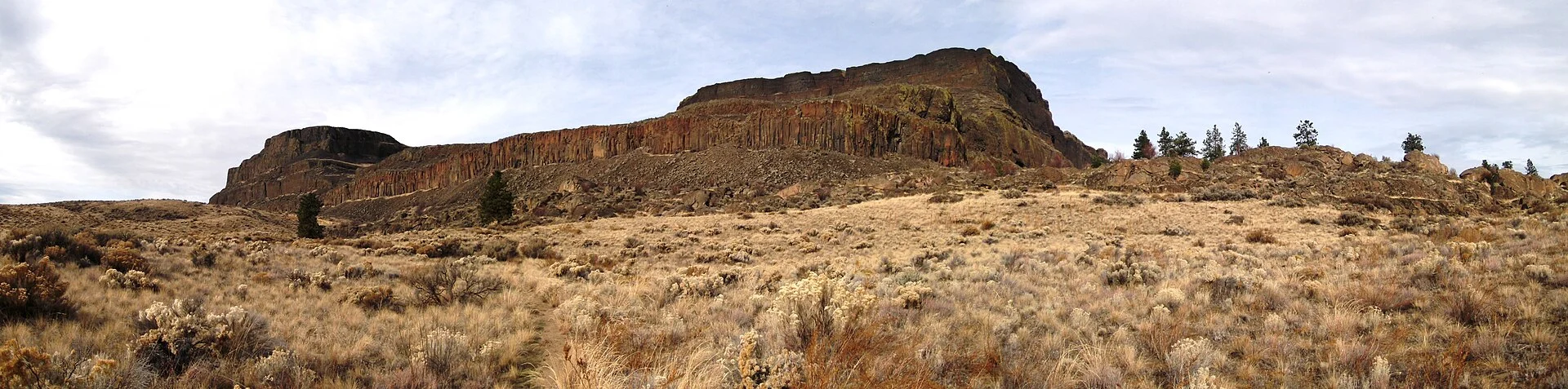
Steamboat Rock State Park — 3,522 acres in the heart of Washington’s Grand Coulee — centers on one of the most dramatic geological formations in the American West: a massive basalt mesa rising 800 feet above Banks Lake, sculpted by the catastrophic Ice Age Missoula Floods. The rock — 2 miles long and half a mile wide, with a flat 600-acre summit — resembles the prow of an enormous steamboat, hence its name. Below the towering basalt cliffs, Banks Lake stretches 27 miles through the Grand Coulee, offering world-class warm-water fishing, swimming, and boating in an arid landscape that receives over 300 days of sunshine annually.
This is Eastern Washington at its most monumental — a landscape of columnar basalt, sage-scented desert air, and big sky that feels more like the American Southwest than the Pacific Northwest. The park is a favorite of geologists, anglers, rock climbers, and families seeking sun-drenched recreation far from the rain shadow of the Cascades.
The Rock: 800-Foot Basalt Mesa
Steamboat Rock is composed of Columbia River Basalt — volcanic lava flows that erupted from fissures in eastern Oregon and Washington between 17 and 6 million years ago. The rock displays at least 12 distinct lava flow layers, each representing a separate eruption event that blanketed the landscape in molten basalt up to 100 feet thick. These flows — part of the largest continental flood basalt province on Earth — once covered 63,000 square miles.
The mesa’s dramatic shape was carved during the Missoula Floods (15,000-13,000 years ago) — among the most catastrophic flood events in geological history. When an ice dam holding glacial Lake Missoula in Montana repeatedly collapsed, walls of water up to 800 feet deep roared across eastern Washington at speeds approaching 65 mph. These floods scoured the Grand Coulee, carving deep channels and leaving Steamboat Rock as an isolated remnant — a basalt island that the floodwaters could not completely erode.
| Geological Feature | Details |
|---|---|
| 📏 Height Above Lake | ~800 feet (700 ft cliffs + 100 ft above water) |
| 📐 Summit Area | 600 acres (flat top, 2 mi × 0.5 mi) |
| 🌋 Rock Type | Columbia River Basalt (12+ lava flows) |
| 🧊 Carved By | Ice Age Missoula Floods (15,000-13,000 BP) |
| 📊 Basalt Age | 17-6 million years old |
Summit Hike
The hike to the summit of Steamboat Rock is the park’s signature experience — a challenging but rewarding ascent to a flat, 600-acre mesa top with 360-degree panoramic views of Banks Lake, the Grand Coulee, and the surrounding basalt cliff landscape.
| Summit Hike Details | Info |
|---|---|
| 📏 Distance | ~3.5 miles round trip (summit via north face trail) |
| ⬆️ Elevation Gain | ~700 feet |
| ⏰ Time | 2-4 hours round trip |
| 💪 Difficulty | Moderate-Strenuous (steep, loose rock sections) |
☀️ Summer Warning: Temperatures regularly exceed 100°F in July-August. There is NO shade and NO water on the summit. Carry at least 2 liters of water per person, wear sun protection, and start early (before 9 AM) in summer. Western rattlesnakes are present — watch where you step on rocky terrain.
The summit itself is a surreal, flat-topped prairie of bunchgrass and wildflowers, with views extending to the distant Cascades on clear days. Prairie falcons and golden eagles nest on the cliff faces and can often be seen riding thermals at eye level from the summit edge. The sunset from the summit — with Banks Lake glowing below and the basalt cliffs turning amber — is unforgettable.
Banks Lake Recreation
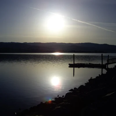
Banks Lake — a 27-mile-long, 7,900-acre reservoir created by Grand Coulee Dam — fills the upper Grand Coulee with Columbia River water pumped uphill for irrigation. The lake’s 50,000+ feet of shoreline provides some of the best warm-water recreation in the Pacific Northwest.
| Banks Lake Feature | Details |
|---|---|
| 🏊 Swimming | Designated swim beaches, water temps reach 75°F+ in summer |
| 🎣 Fishing | Walleye, smallmouth bass, kokanee, largemouth bass, perch, lake trout |
| ⛵ Boat Launches | 7 launches with 320 ft of dock space |
| 🚣 Water Sports | Waterskiing, wakeboarding, jet skiing, kayaking, paddleboarding |
Banks Lake is consistently ranked among Washington’s top walleye and smallmouth bass fisheries. Spring (April-June) is prime for walleye; summer offers excellent topwater bass fishing around rocky shoreline structure. The lake’s warm water temperatures — reaching 75°F+ in summer — make it one of the few lakes in Washington where extended open-water swimming is comfortable.
Camping
| Site Type | Count | Details |
|---|---|---|
| 🏕️ Standard Tent | 26 | Near swim beach, shaded |
| 🔌 Full Hookup (RV) | 100 | Water, electric, sewer — RVs to 60ft |
| ⛵ Boat-In Primitive | 12 | Accessible only by water, secluded |
| 🏠 Cabins | 3 | Year-round, heated |
Reservations are available at washington.goingtocamp.com. Summer weekends (June-September) book early — this is one of the most popular campgrounds in eastern Washington. The 12 boat-in primitive sites on the far side of Steamboat Rock offer a uniquely secluded camping experience accessible only by water.
Wildlife & Nature
Steamboat Rock State Park — 3,522 acres in the Grand Coulee — features a massive basalt mesa rising 800 feet above Banks Lake, created by the catastrophic Ice Age Missoula Floods. The mesa — 2 miles long and 0.5 miles wide — provides a challenging hike to a flat summit with 360-degree views of Banks Lake, the Grand Coulee, and the surrounding basalt cliffs. Banks Lake — a 27-mile reservoir — offers excellent warm-water fishing (walleye, smallmouth bass, kokanee) and swimming. Mule deer and western rattlesnakes inhabit the rocky terrain. Prairie falcons and golden eagles nest on the basalt cliffs. White pelicans — with 9-foot wingspans — roost on sandbars in impressive flocks. Coyotes howl at dusk across the coulee. The park’s shrub-steppe habitat of sagebrush and bunchgrass supports western meadowlarks, Say’s phoebes, and loggerhead shrikes.
Nearby Attractions
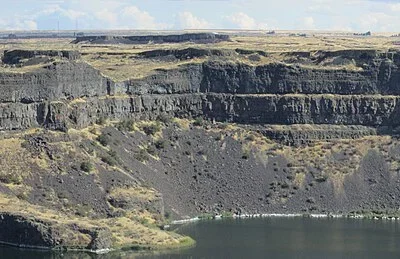
Grand Coulee Dam — 15 miles north — is the largest concrete structure in the United States and the largest hydroelectric producer in North America, with a free nightly laser light show projected onto the dam face (Memorial Day through September). Sun Lakes-Dry Falls State Park — 20 miles south — preserves the site of Dry Falls, the largest waterfall in geological history (3.5 miles wide, 400 feet tall during the Ice Age floods). Lake Lenore Caves — 25 miles south — has flood-carved basalt caves used by ancient peoples. Coulee City — 15 miles south — sits at the south end of Banks Lake with dining and supplies. Electric City — 10 miles north — provides the nearest full services.
How difficult is the summit hike?
The summit hike is moderate to strenuous — about 3.5 miles round trip with 700 feet of elevation gain. The trail includes steep sections with loose rock. In summer, the lack of shade and extreme heat (often 100°F+) makes it significantly harder. Start early, carry plenty of water, and watch for rattlesnakes on rocky terrain.
What fish can I catch in Banks Lake?
Banks Lake is one of Washington’s top warm-water fisheries. Primary species include walleye, smallmouth bass, largemouth bass, yellow perch, and kokanee salmon. Lake trout (mackinaw) are also present in deeper water. Spring (April-June) is best for walleye; summer is excellent for bass.
How far ahead should I reserve a campsite?
Reservations can be made up to 9 months in advance for the peak season (mid-May through mid-September). Summer weekends — especially July 4th and Labor Day — book out quickly. For the best selection, reserve as early as possible at washington.goingtocamp.com.
What created the Grand Coulee?
The Grand Coulee was carved by the Missoula Floods (15,000-13,000 years ago) — catastrophic floods released when ice dams holding glacial Lake Missoula in Montana repeatedly collapsed. Walls of water up to 800 feet deep roared across eastern Washington at 65 mph, scouring deep channels and leaving dramatic basalt formations like Steamboat Rock.
Keep exploring: The closest neighbors are Sun Lakes-Dry Falls State Park (within about an hour’s drive) and Dry Falls State Park (within about an hour’s drive).
🪨 Eastern Washington’s Geological Wonder
Where Ice Age floods carved a monument — climb the 800-foot basalt mesa and fish the 27-mile lake below. Reserve at WA State Parks or call 888-CAMPOUT.
Location & Getting There
Steamboat Rock State Park is located at Highway 155, Electric City, WA 99123, on the west shore of Banks Lake in the upper Grand Coulee. From Spokane (120 miles east), take US-2 west to SR-174 north to SR-155 north. From Seattle (230 miles west), take I-90 east to US-97 north to SR-17 north to SR-155. GPS coordinates: 47.8608, -119.1208. The nearest airport is Grant County International Airport (Moses Lake, 60 miles south).
Quick Facts
- Acreage: 3,522 acres
- Shoreline: 50,000+ feet on Banks Lake
- Rock Height: ~800 feet above Banks Lake
- Summit Area: 600 acres (flat top)
- Lake Size: 27 miles long, 7,900 acres
- Coordinates: 47.8608, -119.1208
- Activities: Hiking, Camping, Fishing, Swimming, Boating, Rock Climbing, Wildlife Viewing
- Pass Required: Discover Pass ($30/year or $10/day)
- Pets: Allowed on leash in most areas
Best Time to Visit
Late May through September is the prime season — hot, sunny weather with lake temperatures reaching 75°F+ for swimming. April-June is best for walleye fishing and wildflowers on the mesa. July-August brings 100°F+ heat — plan summit hikes early morning. Fall (September-October) offers cooler temperatures, fewer crowds, and excellent fishing. The park is open year-round, though winter brings freezing temperatures and occasional snow.
Explore More Washington State Parks
Steamboat Rock State Park is one of many outstanding state parks in Washington. Discover more parks in our Best State Parks in Washington guide, or use our Park Finder to search by activity, location, or features.

Park Location
Plan your gear for Steamboat Rock State Park
From our editorial guides, matched to this park’s activities:

Top Tours & Activities Near Washington
 from $95
 from $289
 from $599