
🌤 Weather at Fort Kent State Historic Site by season
| Spring | Summer | Fall | Winter |
|---|---|---|---|
| 9–61 °F | 47–76 °F | 22–66 °F | -3 to 26 °F |
Each range runs from the coldest monthly average low to the warmest monthly average high in that season (1991-2020 climate normals), measured at Fort Kent, 1 mi away, elevation 610 ft. Conditions at the park can differ from the station, especially where elevation differs — check a forecast before you go.

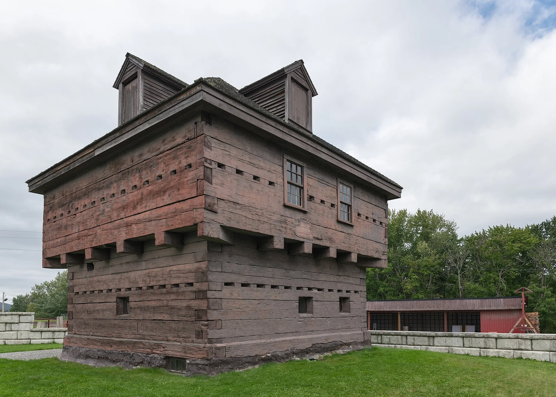
Maine’s Aroostook War Blockhouse — Only Surviving American Fortification, National Historic Landmark, US-Canada Border, St. John River, 1839 Log Blockhouse
Fort Kent State Historic Site is a state historic site in Fort Kent, Aroostook County, Maine, at the confluence of the Fish River and St. John River on the US-Canada border. The site preserves the only surviving American fortification from the Aroostook War (1838–1839) — a National Historic Landmark log blockhouse built in 1839, named after Maine Governor Edward Kent, featuring a museum with historical displays, and commemorating the bloodless boundary dispute between the United States and Great Britain.
Fort Kent’s log blockhouse is the sole surviving American fortification from the Aroostook War — often called the “Pork and Beans War” — a bloodless boundary dispute between the US and Great Britain over the Maine-New Brunswick border. Built in 1839 at the strategic confluence of the Fish and St. John Rivers, the fort was named after Governor Edward Kent of Maine. The crisis was resolved by the Webster-Ashburton Treaty of 1842, which established the current international border. Today the restored blockhouse serves as a museum with historical displays about the conflict, the St. John River Valley, and the region’s French-Acadian heritage. The site sits at Maine’s northernmost point, where the town of Fort Kent looks across the river to Clair, New Brunswick, Canada.
Things to Do
Historic Exploration
- 1839 log blockhouse — only surviving Aroostook War fortification
- Museum displays — Aroostook War history
- Webster-Ashburton Treaty context
- French-Acadian heritage
Scenic
- Fish River + St. John River confluence
- US-Canada border views
- Clair, New Brunswick across the river
Park Information
| Feature | Details |
|---|---|
| Location | Fort Kent, Aroostook County, ME — Maine’s northernmost point |
| Designation | National Historic Landmark |
| Built | 1839 — Aroostook War |
| Named After | Governor Edward Kent of Maine |
| Conflict | Aroostook War (1838–39) — “Pork and Beans War” |
| Resolution | Webster-Ashburton Treaty (1842) |
| Museum | Blockhouse interior — historical displays |
| Season | Summer (Memorial Day–Labor Day) |
| Admission | FREE — donations accepted |
| Coordinates | 47.2528° N, 68.5950° W |
Best Time to Visit
| Season | Highlights | Considerations |
|---|---|---|
| Summer (Jun–Aug) | ⭐ BEST: Museum open; full access; long days; combine with Allagash trips; rivers active | Remote location — plan driving time; mosquitoes near rivers |
| Fall (Sep–Oct) | Autumn foliage; quiet; river scenery; harvest festivals | Museum may close after Labor Day; verify hours |
| Winter | Snowmobile trails; winter scenery; can-am connection | Museum CLOSED; extreme cold; remote; short days |
| Spring (Apr–May) | River ice-out; spring migration; French-Acadian culture events | Mud season; museum not yet open; variable weather |
Visitor Tips
- Only survivor: This is the ONLY surviving American fortification from the Aroostook War — a unique National Historic Landmark.
- Bloodless war: The “Pork and Beans War” was resolved without combat — the Webster-Ashburton Treaty of 1842 established the current US-Canada border.
- Border town: Fort Kent sits at Maine’s northernmost point — look across the St. John River to Clair, New Brunswick, Canada.
- Remote: Fort Kent is ~3.5 hours north of Bangor — plan your visit as part of a northern Maine road trip (Allagash Wilderness Waterway, Acadian Village).
- Allagash: Fort Kent is the northern terminus of the Allagash Wilderness Waterway — canoeists finishing the 92-mile trip end near here.
- Free: No admission fee — donations appreciated.
Wildlife & Nature
Fort Kent SHS — built during the Aroostook War (1838-1839) — the bloodless border dispute between the US and Britain over the Maine-New Brunswick boundary. The restored blockhouse is one of the northernmost historic forts in the eastern US. The site’s St. John and Fish Rivers support bald eagles and Atlantic salmon.
Nearby Attractions
Fort Kent — adjacent — the northern terminus of US Route 1 (which runs 2,369 miles to Key West, FL). New Brunswick, Canada — across the river.
What is Fort Kent State Historic Site in Maine?
Fort Kent State Historic Site in Fort Kent, Maine, preserves the only surviving American fortification from the Aroostook War of 1838–1839. The National Historic Landmark log blockhouse was built in 1839 at the confluence of the Fish and St. John Rivers on the US-Canada border. Named after Maine Governor Edward Kent, the fort commemorates the bloodless boundary dispute between the United States and Great Britain, resolved by the Webster-Ashburton Treaty of 1842. The blockhouse serves as a museum with historical displays. It is free to visit, typically open Memorial Day through Labor Day.
Last updated: May 2026
Nearby state parks: If you have extra time, Salmon Brook Lake Bog is within about an hour’s drive, and Allagash Wilderness Waterway is within about an hour’s drive.

🐾 Dogs & Pets at Fort Kent State Historic Site
- Pets allowed? statewide rule
- Pets are allowed at most Maine state parks year-round, including trails, but must be leashed, under the handler's physical control and never left unattended.
- Leash rule statewide rule
- Leash not exceeding 4 feet, under the physical control of the handler
- Beaches & swim areas statewide rule
- Pets are not allowed on state park beaches April 1 through September 30; leashed pets are welcome on beaches October 1 through March 31
- Statewide exceptions statewide rule
- No pets allowed at Sebago Lake State Park campground; park staff may assign pet owners to less congested camping areas
Are dogs allowed at Fort Kent State Historic Site?
Pets are allowed at most Maine state parks year-round, including trails, but must be leashed, under the handler's physical control and never left unattended. Individual parks can post stricter rules — check signage on arrival.
Rules verified July 2026 via maine.gov. More: Maine state parks guide · Dog rules in all 50 states compared
Park Location
Plan your gear for Fort Kent State Historic Site
From our editorial guides, matched to this park’s activities:

Top Tours & Activities Near Tadoussac
 from $109
 from $159