A Temperate Rainforest in the Southern Appalachians — Where 90 Inches of Rain Create North Carolina’s Waterfall Capital
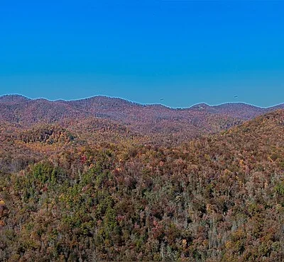
Gorges State Park occupies 7,709 acres of some of the most dramatic terrain in the eastern United States — a landscape of sheer river gorges, ancient granite cliffs, and dense Appalachian forest that receives more rainfall than anywhere else east of the Pacific Northwest. With over 90 inches of precipitation annually, this narrow corridor along the North Carolina-South Carolina border functions as a genuine temperate rainforest, creating conditions that support one of the highest concentrations of waterfalls in the Southern Appalachians and a biodiversity that includes more rare and endemic species per acre than most national parks.
The park sits at the edge of the Blue Ridge Escarpment — a dramatic geological feature where the Appalachian Plateau drops roughly 2,000 feet to the Piedmont below over a distance of just a few miles. This extreme vertical relief, combined with the region’s extraordinary rainfall, creates rivers that don’t merely flow downhill — they plunge off cliff faces in cascades that reach 150 feet, carve through granite gorges that echo with the constant sound of moving water, and sustain old-growth forest ecosystems that have been developing undisturbed for thousands of years.
🌿 At a Glance
- Size: 7,709 acres
- Annual Rainfall: 90+ inches — creating a temperate rainforest ecosystem
- Trail Network: 56 miles of hiking, biking, and equestrian trails
- Location: Transylvania County, NC — the “Land of Waterfalls”
- Admission: Free
- Visitor Center: Open daily 9 AM–5 PM (closed Christmas Day)
The Waterfalls: Why Transylvania County Is Called the “Land of Waterfalls”
Gorges State Park serves as the gateway to some of the most spectacular waterfalls in the eastern United States. Several of the most famous cascades technically lie just outside park boundaries in the adjacent Pisgah National Forest, but are accessed via park trails — a geographic detail that matters to cartographers far more than to visitors standing in the spray of a 150-foot cascade.
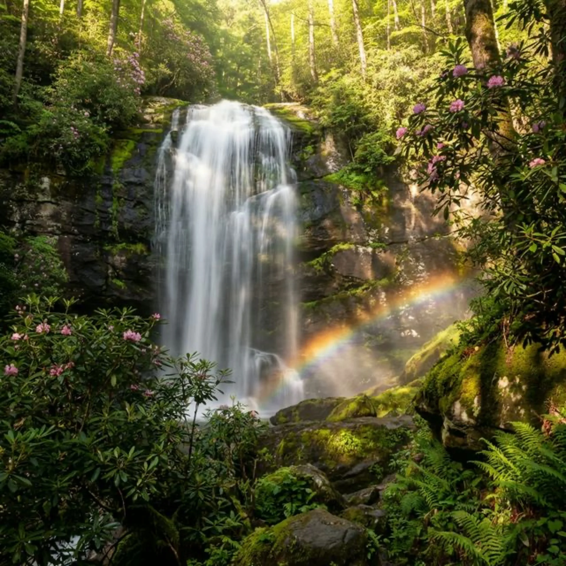
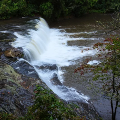
Rainbow Falls — The Crown Jewel
Rainbow Falls is the park’s marquee attraction and one of the most photographed waterfalls in the Blue Ridge Mountains. The Horsepasture River drops 150 feet over a wide granite ledge in a single dramatic plunge, creating a perpetual mist cloud that — true to its name — produces visible rainbows on sunny days, typically between 10 AM and 2 PM when the sun angle hits the spray at the correct degrees. The hike to Rainbow Falls is a 3-mile round trip from the Grassy Ridge main entrance, with moderate difficulty. The trail descends steadily from the trailhead, which means the return climb gains roughly 500 feet of elevation and feels more strenuous than expected after an hour of standing in waterfall spray.
Turtleback Falls — Nature’s Water Slide
Turtleback Falls sits upstream from Rainbow Falls on the Horsepasture River, and it is exactly what the name suggests: a broad, smooth, dome-shaped rock formation over which the river flows in a wide sheet before dropping into a deep natural swimming pool below. In summer, this becomes one of the most popular natural swimming holes in the Southern Appalachians, with visitors sliding down the slick rock face into the cold mountain water below. The experience is exhilarating, genuinely fun, and carries real risk — the rocks are slippery, the water is cold enough to cause gasping, and the pool depth varies. Proceed with appropriate caution and common sense.
More Cascades Worth Finding
| Waterfall | Height | Trail Distance | Notes |
|---|---|---|---|
| Rainbow Falls | 150 ft | 3 mi RT | Crown jewel, literal rainbows on sunny days |
| Turtleback Falls | 20 ft | 3.5 mi RT | Natural water slide and swimming hole |
| Stairway Falls | 100+ ft | 4 mi RT | Multi-tiered cascade, less crowded |
| Upper Bearwallow Falls | 60 ft | 0.5 mi RT | Short, steep trail to powerful cascade |
| Bearwallow Falls | 75 ft | 1.5 mi RT | Overlook trail, limited viewing angle |
| Hidden Falls | 40 ft | 4 mi RT | Secluded cascade on the Horsepasture River |
Trail System: 56 Miles Through a Living Rainforest
The park’s 56-mile trail network ranges from easy interpretive walks near the visitor center to strenuous wilderness treks descending to Lake Jocassee on the South Carolina border. Many trails are multi-use, accommodating hikers, mountain bikers, and horseback riders, though the waterfall trails are hiking-only. Trail conditions vary significantly with weather — after heavy rain (which occurs frequently in a 90-inch rainfall zone), creek crossings can become dangerous and trails transform into muddy, slippery challenges that demand appropriate footwear.
Top Hiking Trails
| Trail | Distance | Difficulty | Highlights |
|---|---|---|---|
| Rainbow Falls Trail | 3 mi RT | Moderate | Rainbow Falls, Turtleback Falls, Horsepasture River |
| Bearwallow Falls Trail | 1.5 mi RT | Easy-Moderate | Overlook of Bearwallow Falls cascade |
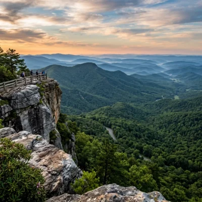
| Bearwallow Valley Trail | 2.3 mi loop | Moderate | 3,200 ft overlook — views into SC, Lake Jocassee |
| Foothills Trail | 6.7 mi (section) | Strenuous | Part of the 76-mile Foothills Trail, passes Whitewater Falls |
| Canebrake Trail | 10 mi RT | Strenuous | Descends to Lake Jocassee shoreline |
| Auger Hole Trail | 14.4 mi RT | Strenuous | Remote wilderness, river crossings required |
| Picnic Connector | 0.8 mi RT | Easy | Casual walk connecting two picnic areas |
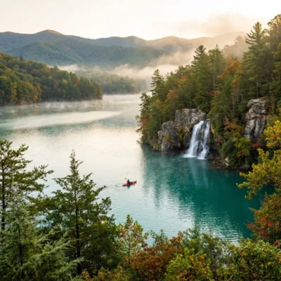
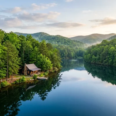
The Canebrake Trail descends 5 miles from the Frozen Creek Access to the shores of Lake Jocassee, a crystalline mountain reservoir that straddles the NC-SC border. This is a strenuous hike primarily because of the return trip — you lose roughly 2,000 feet of elevation on the way down, and every foot must be regained on the hike out. But the reward is one of the most scenic and isolated lakeshore settings in the Southern Appalachians, where the trail connects with the 76-mile Foothills Trail for those pursuing multi-day backpacking adventures.
The Auger Hole Trail is the park’s most remote option — a 14.4-mile round trip from the Frozen Creek Access through genuine wilderness terrain that includes multiple river fords. This is a trail for experienced hikers who are comfortable with route-finding, stream crossings, and spending extended time in conditions where help is far away. Mountain bikes and horses are permitted, adding a multi-use dimension to the already challenging route.
Biodiversity: A Hotspot of Global Significance
Gorges State Park sits within the Southern Blue Ridge Escarpment, an area recognized by The Nature Conservancy and other conservation organizations as one of the most biologically significant regions in the temperate world. The combination of extreme rainfall, dramatic elevation changes, and complex topography creates a mosaic of microclimates that support an astonishing range of species — from the cold-loving organisms of the high ridges to the warm-adapted species of the lower gorges.
The park harbors more rare and endangered species per acre than many areas ten times its size. Notable residents include the Oconee bell (Shortia galacifolia), one of the rarest wildflowers in North America, found only in a handful of locations in the Southern Appalachians. The rivers support populations of Eastern hellbender — a two-foot-long fully aquatic salamander sometimes called the “snot otter” — that serves as a water quality indicator species. Black bears are common, white-tailed deer browse the forest edges, and the old-growth canopy provides habitat for cerulean warblers, black-throated blue warblers, and other neotropical migrants that depend on mature Appalachian forest.
The botanical diversity is staggering. Spring brings successive waves of wildflowers — trillium, bloodroot, Jack-in-the-pulpit, fire pink, and galax — while the forest understory features thickets of rhododendron and mountain laurel that bloom spectacularly in late May and June. The canopy includes tulip poplar, white oak, eastern hemlock, fraser magnolia, and — in the higher, wetter areas — moss-covered beech and birch that give the forest its rainforest character.
Fishing: Mountain Trout in Pristine Waters
The park’s streams and rivers offer excellent fishing for anglers willing to navigate steep terrain to reach the water. Bearwallow Creek and the Toxaway River support populations of rainbow trout and brown trout, with smallmouth bass in the larger pools. The streams run cold and clear even during summer, fed by the constant rainfall and subsurface springs that emerge from the granite bedrock.
North Carolina Wildlife Resources Commission regulations apply, and a valid NC fishing license with a trout stamp is required. The streams here are not stocked — these are wild fish populations maintained by the watershed’s exceptional water quality. Catch-and-release is strongly encouraged, and the limited access keeps fishing pressure far below levels that would threaten fish populations.
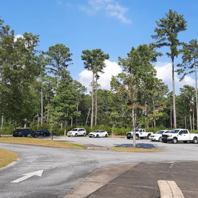
Two Access Points: Planning Your Visit
Gorges State Park has two distinct entrance areas, each providing access to different sections of the trail network. Understanding which entrance to use is essential for planning your visit efficiently.
🚗 Park Access Areas
- Grassy Ridge Main Entrance (976 Grassy Ridge Rd, Sapphire, NC) — Primary entrance with visitor center, Rainbow Falls trailhead, Bearwallow Falls Trail, Upper Bearwallow Falls. Open year-round.
- Frozen Creek Access (Frozen Creek Rd, Brevard, NC) — Eastern entrance for Canebrake Trail, Auger Hole Trail, Foothills Trail connector, backcountry camping access. May close seasonally due to winter weather.
Seasonal Rhythms: Timing Your Visit
In a park that receives 90+ inches of rain, weather is a constant companion rather than an occasional disruption. Every season offers a fundamentally different experience, and each has its own rewards and challenges.
📅 Seasonal Guide
- March – May: ⭐ Wildflower season. Successive waves of blooms, rhododendron/mountain laurel peak in late May. Waterfalls at peak flow. Trails can be muddy.
- June – August: Full canopy, swimming at Turtleback Falls, warmest weather (70s-80s). Afternoon thunderstorms frequent. Highest visitor volume.
- September – November: ⭐ Fall color (peak typically mid-October). Clear skies, comfortable temperatures, reduced crowds. Excellent hiking conditions.
- December – February: Frozen Creek Access may close. Limited daylight. Waterfalls ice in extreme cold. Solitude guaranteed. Check trail conditions before visiting.
The waterfalls are most dramatic during and immediately after heavy rain — which can occur any month but peaks in spring and mid-summer. However, trail safety also deteriorates during heavy rain events. The best strategy is to visit 1-2 days after a significant rain, when the waterfalls are running full but the trails have had time to drain. The visitor center staff can advise on current conditions and recommend the best trails for the day’s weather.
Camping
Gorges State Park offers primitive backcountry campsites accessible via the longer trails from the Frozen Creek Access. These are true primitive sites — no water, no facilities, no bear boxes. Pack in everything you need and pack out everything you don’t consume. Camping fees apply, and permits can be obtained at the visitor center. During winter months, backcountry campsites may be closed along with the Frozen Creek Access area.
For developed campground amenities, several options exist within 30 minutes of the park, including campgrounds in Pisgah National Forest and private campgrounds near Brevard and Sapphire. The park’s “carry-in, carry-out” trash policy extends to camping — there are no trash receptacles anywhere in the park.
Getting There
| From | Distance | Drive Time | Route |
|---|---|---|---|
| Asheville, NC | 55 mi | 1.5 hrs | US-64 W through Brevard to Sapphire |
| Brevard, NC | 25 mi | 35 min | US-64 W to Grassy Ridge Rd |
| Greenville, SC | 75 mi | 1.5 hrs | US-276 N to NC-281 S |
| Charlotte, NC | 175 mi | 3 hrs | I-26 W to US-64 W |
| Atlanta, GA | 190 mi | 3.5 hrs | I-85 N to US-276 N |
�� Visitor Essentials
- Admission: Free
- Carry-in, carry-out: NO trash cans in the park — you must take all trash with you
- Footwear: Waterproof hiking boots essential — trails are frequently muddy/wet
- Pets: Allowed on leash (6 ft max), not in buildings
- Creek crossings: Can become dangerous after heavy rain. Check conditions at the visitor center
- Cell service: Limited to none in gorge areas. Download maps before arriving
- Swimming: At your own risk. Water is cold (55-65°F even in summer) and rocks are slippery
- Contact: (828) 966-9099 | [email protected]
Gorges State Park is not the easiest park to reach, not the most developed, and not the most famous in North Carolina’s excellent state park system. What it is, simply, is the wildest. In a state known for its mountains, this park takes you to where those mountains make their most dramatic stand — where rivers launch themselves off cliffs, where rainfall creates a self-sustaining rainforest ecosystem, and where a trail through rhododendron-draped old-growth forest can make you forget, for a few hours, that you’re in the most eastern timezone of the continental United States and not somewhere far more remote and primal. The gorges earned their name. Earn your visit.
Frequently Asked Questions
What activities are available at this state park?
Common activities include hiking, camping, fishing, swimming, picnicking, and wildlife watching. Check the park website for specific offerings, trail maps, and seasonal programs.
Do I need a reservation to camp?
Reservations are recommended for camping, especially on weekends and holidays during peak season. Most state park systems offer online reservation portals where you can book sites months in advance.
Are dogs allowed at this state park?
Dogs are typically allowed in campgrounds and on most trails but must be kept on a leash (usually 6 feet). Dogs are often prohibited at swimming beaches. Service animals are always welcome. Check specific park rules.
What is the best time to visit?
Spring and fall generally offer the most comfortable weather for outdoor activities. Summer is peak for swimming and camping. Check the specific park for seasonal closures and optimal visiting conditions.
Explore More North Carolina State Parks
Gorges State Park is one of many outstanding state parks in North Carolina. Discover more parks in our Best State Parks in North Carolina guide, or use our Park Finder to search by activity, location, or features.
Nearby state parks: If you have extra time, Jocassee Gorges is a short drive away, and Sliding Rock Recreation Area is within about an hour’s drive.

Park Location
Plan your gear for Gorges State Park
From our editorial guides, matched to this park’s activities:
Top Tours & Activities Near Greenville
 from $40
 from $110
 from $100