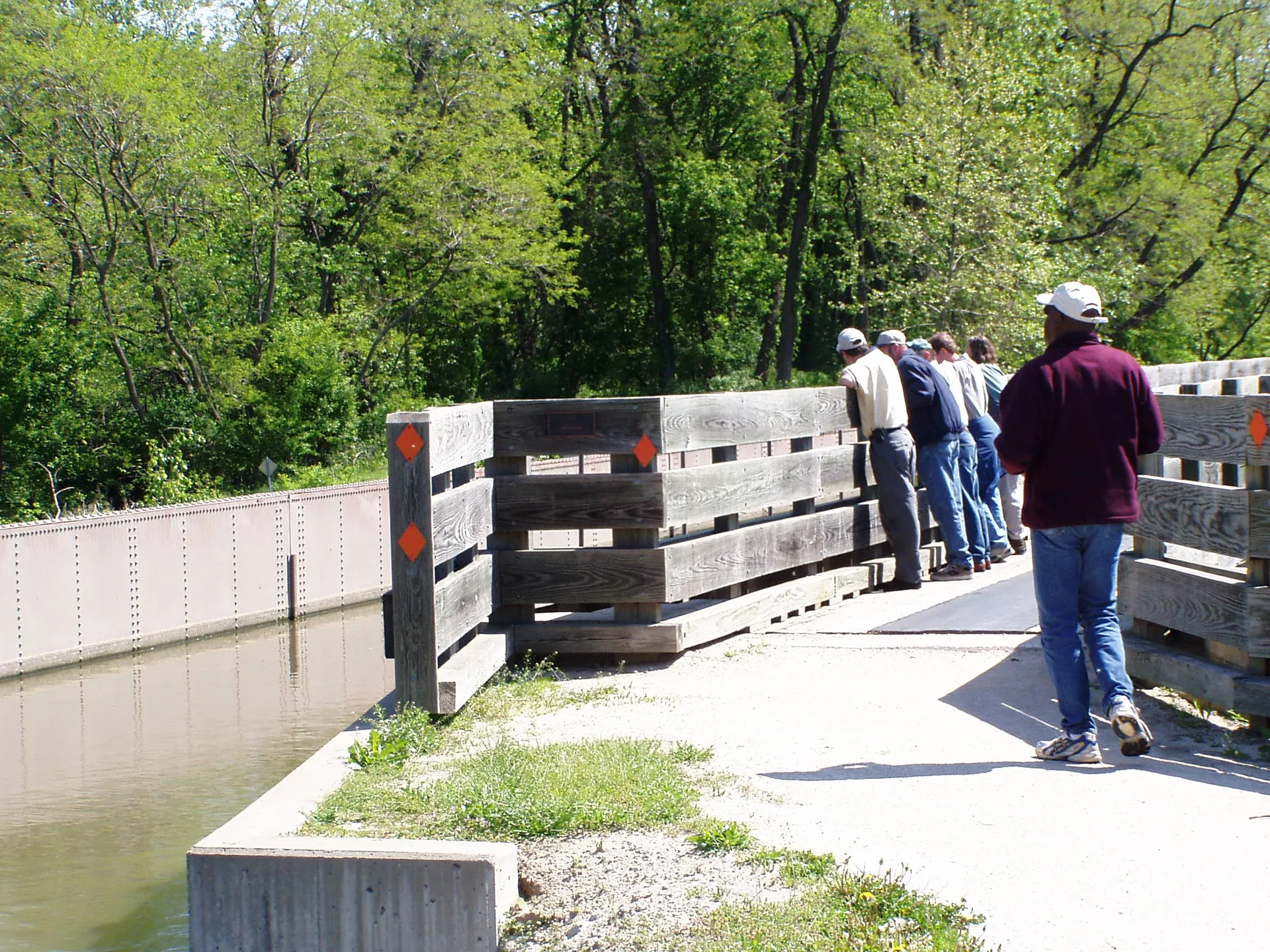
Photo: Chris Light, CC BY-SA 4.0, via Wikimedia Commons
🌤 Weather at Illinois and Michigan Canal State Trail by season
| Spring | Summer | Fall | Winter |
|---|---|---|---|
| 29–72 °F | 61–85 °F | 32–77 °F | 16–37 °F |
Each range runs from the coldest monthly average low to the warmest monthly average high in that season (1991-2020 climate normals), measured at Morris 1 NW, 2 mi away, elevation 524 ft. Conditions at the park can differ from the station, especially where elevation differs — check a forecast before you go.

The Illinois and Michigan Canal State Trail is a 61.5-mile Illinois DNR towpath from Rockdale to LaSalle, beside a canal that opened in 1848, with its official trailhead at Channahon State Park.
The trail runs through Will, Grundy and LaSalle counties and covers only part of the 96-mile canal, so check which one a mileage refers to before you plan a ride.
Rules and facilities below were checked against the Illinois Department of Natural Resources (IDNR) I&M Canal pages and the pages of the state parks along the trail in November 2026. IDNR’s trail page lists no street address or phone number of its own and tells you to call the nearest park office, so this guide gives the offices at Gebhard Woods in Morris and at Channahon.
Quick Facts
| Managed by | Illinois Department of Natural Resources |
| Length | 61.5 miles, Rockdale to LaSalle (some IDNR park pages round this to 61) |
| Surface | Limestone screenings on the old towpath, marked, with wayside exhibits |
| Open to | Walkers and cyclists; snowmobiles after at least 4 inches of snow; cross-country skiers |
| Not allowed | Horses and metal detecting |
| Paddling | 15 miles from Channahon to Gebhard Woods, 5 miles from Utica to LaSalle (details) |
| Camping | Carry-in only, with a permit from a park office (details) |
| Entrance fee | None; IDNR charges no entrance fee on state land except Wildlife Prairie Park and sites with beaches |
| Offices | Gebhard Woods, 401 Ottawa Street, Morris, 815-942-0796; Channahon, 815-467-4271 |
Canal, Trail or Heritage Area?
Three things share the I&M name, and sources mix them up. They have different lengths and different managers.
- The canal is 96 miles long, from the South Branch of the Chicago River at Bridgeport to the Illinois River at LaSalle.
- The state trail is the 61.5 miles that IDNR manages for visitors, from Rockdale to LaSalle. This page covers the trail.
- The National Heritage Area is a region, not a route. It was designated in 1984 as the first in the country, and the National Park Service names the Canal Corridor Association as its coordinating entity.
Lockport and its restored Gaylord Building sit on the Chicago-to-Rockdale part of the canal, which IDNR describes but does not count in the 61.5 miles.
Stops from East to West
IDNR gives only a few distances along the towpath: 8 miles from Channahon to Aux Sable, 15 miles of canal from Channahon to Gebhard Woods, and 5 miles from the Fox River Aqueduct to Buffalo Rock. It publishes no full mileage table, so ask a park office before you plan a long day.
| Channahon State Park | Official trailhead, with Locks 6 and 7 and the locktender’s house at Lock 6. From I-55, take the Route 6 exit west to Canal Street, turn left, then turn right on Story Street. If the lot is full, the Jessup Street lot is one block farther on Canal Street. Water fountains and restrooms in the park. |
| Aux Sable access | Aux Sable Aqueduct, Lock 8 and an original locktender’s house. Canoe access and an accessible vault toilet. |
| Gebhard Woods State Park, Morris | A footbridge from the trail. Restored Nettle Creek stone aqueduct, water, restrooms, an information center and e-bike rental (Adventur-E-Bike, 815-313-9416). |
| William G. Stratton State Park, Morris | The trail forms its northern boundary. Water and restrooms near the launching area, and four boat ramps on the Illinois River. By car, follow Route 47 to Illinois Avenue, go west to Calhoun Street, turn left over the canal, then turn left on Griggs Street. |
| Seneca | M.J. Hogan Grain Elevator, which IDNR calls the only remaining historic grain elevator along the canal from its early days. To arrange a tour, call the Gebhard Woods office. |
| Ottawa | Fox River Aqueduct, the largest on the canal. |
| Buffalo Rock access | Parking for about seven vehicles and no water or restrooms. Buffalo Rock State Park is across the road, with the Effigy Tumuli earth sculptures nearby and e-bike rental from the same company. |
| Lock 14 and First Street, LaSalle | Canoe access at Lock 14. The Canal Corridor Association’s Lock 16 Visitor Center, 754 First Street, runs cruises on a full-size replica canal boat with guides in period dress (815-220-1848). From I-80, take Exit 77 south on Route 351 to First Street. Call for the current schedule. |
Bring your own water for long stretches. IDNR’s accessibility page says no outdoor water fountains are available on the trail, so fill up in the parks listed above.
On the Towpath
The old towpath is level, easy walking, and mules and horses once pulled barges along it. Horses are not allowed today because of the trail’s composition. Wayside exhibits explain the canal-era sights as you pass them.
In winter, snowmobiles may use the marked trail once at least 4 inches of snow have fallen. Call the nearest park office for conditions before you trailer a machine. IDNR’s Gebhard Woods page also permits cross-country skiing on the trail.
Paddling and Boating
IDNR lists two canal stretches for canoes: 15 miles of open water between Channahon and Gebhard Woods, and 5 miles between Utica and LaSalle. You can launch at the Aux Sable Aqueduct and at Lock 14 in LaSalle. Aux Sable also makes a good lunch stop on the longer stretch.
Small fishing boats may use electric motors. Gas motors are prohibited because the canal is shallow and its embankments are fragile. For gas-powered boating, fishing or water-skiing, use the four ramps on the Illinois River at William G. Stratton State Park.
Fishing
In the canal, expect bass, crappie, bluegill, carp, catfish and bullhead. Gebhard Woods adds three small ponds, and river fishing is popular on the Illinois River at Stratton.
Camping
You carry everything in. Backpackers may camp at designated sites along the trail, and Channahon and Gebhard Woods also have primitive tent and youth group camping. Get a permit from a park office before you camp. Fires are allowed only in the camp stoves and fire pits provided.
- Gebhard Woods: a walk of about 1/3 mile from your car, with no vehicle access to the sites. Fire rings, tables and grills at the sites, with a drinking fountain and pit toilets a short distance away.
- Channahon: gear must also be walked in. Same fire rings, tables and grills, with a drinking fountain and pit toilets a short distance away.
The canal pages give no nightly fee, so ask when you get your permit. They also list no drive-in or RV sites on the trail.
The Canal in Brief
French explorers Joliet and Marquette saw the value of this route in the 1600s, and Native Americans and traders used it heavily until Illinois created a Canal Commission in 1823. The canal was finished in 1848 at a cost of $6.5 million, 60 feet wide and 6 feet deep, with 15 locks. It gave the country its first complete water route from the East Coast to the Gulf of Mexico.
The National Park Service links Chicago’s rapid growth directly to the canal. Railroads began running alongside it in 1853, and the opening of the Illinois Waterway closed it to navigation in 1933. Civilian Conservation Corps crews then restored Locks 6 and 7 at Channahon and built the large shelter that still stands there. The canal is on the National Register of Historic Places and is a federal historic landmark, which is why IDNR bans metal detecting on the trail and at Channahon, Stratton, Gebhard Woods and Buffalo Rock.
Accessibility
IDNR says the parking lots are asphalt with accessible spaces, about 20 feet from the concrete sidewalk. Accessible vault toilets are at the Aux Sable and Bridge Street lots. Service animals are welcome. IDNR does not rate the towpath surface or its grade for wheelchairs, so call a park office if you need that detail.
When to Go
IDNR points to spring for wildflowers along the trail, with great blue herons and waterfowl feeding or nesting near Channahon and on the canal banks. Snowmobiling depends on snowfall, so call about conditions before you drive out.
Nearby Parks
Distances are straight-line from the stop named.
- Channahon State Park, Gebhard Woods State Park and William G. Stratton State Park sit directly on the trail.
- Heidecke Lake State Fish & Wildlife Area is about 5 miles east of the trail at Morris.
- Illini State Park is about 15 miles west-southwest of the trail at Morris.
- Starved Rock State Park and Matthiessen State Park are about 4 and 7 miles from Buffalo Rock State Park.
Frequently Asked Questions
Is the I&M Canal State Trail 96 miles long?
No. The canal is 96 miles long, but IDNR’s state trail covers 61.5 miles of it, from Rockdale to LaSalle.
Can you ride a horse on the I&M Canal State Trail?
No. IDNR does not allow horseback riding on the trail because of its composition.
Where can you get water on the trail?
IDNR lists no outdoor water fountains on the trail itself, so use the water at Channahon, Gebhard Woods or William G. Stratton State Park.
Can you camp along the trail?
Yes, at designated carry-in sites and at the primitive tent areas at Channahon and Gebhard Woods, with a permit from a park office before you camp.
Explore More Illinois State Parks
Discover more parks in our Best State Parks in Illinois guide, or use our Park Finder to search by activity, location, or features.

🐾 Dogs & Pets at Illinois and Michigan Canal State Trail
- Pets allowed? statewide rule
- Pets are allowed in Illinois state parks and on trails as long as they are leashed at all times.
- Leash rule statewide rule
- Leash required at all times; state code caps leash length at 10 feet
- Beaches & swim areas statewide rule
- Pets are prohibited in areas posted 'NO PETS', reserved for beach areas, concession areas and crowded campground/picnic areas (e.g. no dogs on the beach at Illinois Beach State Park)
- Cabins & lodging statewide rule
- Pets are not allowed in campground cabins
- Statewide exceptions statewide rule
- Leash rule exceptions for hunting dogs, field trials and dog training areas; pets must not be left unattended
Are dogs allowed at Illinois and Michigan Canal State Trail?
Pets are allowed in Illinois state parks and on trails as long as they are leashed at all times. Individual parks can post stricter rules — check signage on arrival.
Rules verified July 2026 via dnr.illinois.gov. More: Illinois state parks guide · Dog rules in all 50 states compared
Park Map
Plan your gear for Illinois and Michigan Canal State Trail
From our editorial guides, matched to this park’s activities:
Top Tours & Activities around Chicago (about 55 mi away)
 from $508
 from $35
 from $35