Columbia River Gorge National Scenic Area
🌊 America’s Waterfall Capital — 80+ waterfalls in a single river canyon, the only sea-level route through the Cascades, 4,000-foot basalt cliffs, and one of the world’s greatest concentrations of hiking trails
The Columbia River Gorge is nature’s masterwork in slow motion — a 4,000-foot-deep canyon carved over millions of years where the Columbia River slices through the Cascade Range, creating the only sea-level passage between the Pacific Northwest coast and the interior plateau. Stretching 80 miles along the Oregon-Washington border, this National Scenic Area protects one of the most visually dramatic landscapes in North America: towering basalt cliffs draped with ribbons of falling water, dense old-growth forests, and windswept plateaus that transition from rainforest to desert within a single hour’s drive. The concentration of waterfalls alone — **over 80 within the Gorge** — makes this one of the most waterfall-dense places on Earth.
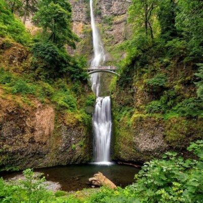
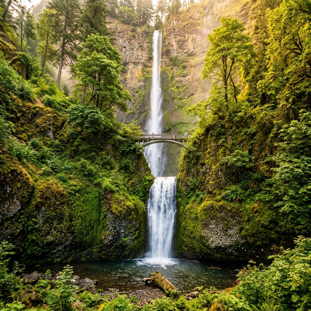
For hikers, the Columbia Gorge is paradise. The Oregon side alone features dozens of trail systems ranging from paved viewpoint walks to multi-day wilderness treks. The famous “Waterfall Corridor” along the Historic Columbia River Highway packs seven major waterfalls into a 10-mile stretch, including Multnomah Falls, Oregon’s tallest waterfall and the most-visited natural recreation site in the Pacific Northwest.
Must-See Waterfalls
| Waterfall | Height | Hike Distance | Difficulty | Highlight |
|---|---|---|---|---|
| Multnomah Falls | 620 ft | 0.2 mi to viewpoint | Easy | Oregon’s tallest; iconic Benson Bridge; crowded but unmissable |
| Latourell Falls | 249 ft | 2.4 mi loop | Moderate | Single plunge over golden basalt columns; less crowded |
| Wahclella Falls | 350 ft (total) | 2 mi round-trip | Easy-Moderate | Fern-lined canyon; one of the most rewarding short hikes |
| Horsetail / Ponytail Falls | 176 / 80 ft | 2.7 mi loop | Moderate | Walk behind Ponytail Falls; roadside access to Horsetail |
| Bridal Veil Falls | 120 ft | 0.5 mi round-trip | Easy | Two-tiered; beautiful viewpoint platform |
| Wahkeena / Fairy Falls | 242 / 20 ft | 5 mi loop | Moderate-Hard | Storybook forest setting; connects to Multnomah Falls |
| Eagle Creek to Punchbowl | Varies | 4 mi round-trip | Moderate | Classic gorge adventure; cliff-edge trail; multiple waterfalls |
Best Hiking Trails
| Trail | Distance | Elevation Gain | Difficulty | Best For |
|---|---|---|---|---|
| Beacon Rock | 1.8 mi RT | 680 ft | Moderate | Switchback climb up 848-ft volcanic monolith; 360° views |
| Angels Rest | 4.6 mi RT | 1,500 ft | Hard | Panoramic gorge views from rocky summit |
| Dog Mountain | 6.9 mi RT | 2,800 ft | Strenuous | Spring wildflower meadows; best views in the Gorge |
| Hamilton Mountain | 7.8 mi RT | 2,100 ft | Strenuous | Washington side; Hardy/Rodney Falls along the way |
| Larch Mountain from Multnomah | 14 mi RT | 4,000 ft | Very Strenuous | Epic day hike; five waterfalls; Cascade volcano views |
Visitor Information
Permits & Parking
- Waterfall Corridor Timed Permits: Required May–September for the Historic Highway section (Bridal Veil to Ainsworth). Book online in advance — they sell out quickly
- NW Forest Pass: Required at many trailheads ($5/day or $30/annual)
- Multnomah Falls: Free to visit, but parking is extremely limited. Consider the Columbia Gorge Express shuttle from Portland
- Peak times: Weekends June–October are busiest. Arrive before 8:30 AM or visit weekdays
Visitor Centers
- Columbia Gorge Discovery Center (The Dalles): Full museum with geology, ecology, and Lewis & Clark exhibits
- Multnomah Falls Lodge: Historic 1925 lodge with information desk, restaurant, and gift shop
- Gateway to the Gorge (Troutdale): Starting point for Portland-area visitors
Best Time to Visit
| Season | Temp Range | Best For | Notes |
|---|---|---|---|
| 🌸 Spring (Mar–May) | 45–65°F | Peak waterfall flow, wildflowers (Dog Mountain) | Some trails muddy; rain likely but dramatic |
| ☀️ Summer (Jun–Aug) | 65–90°F | Hiking, swimming holes, all trails open | Timed permits required; very crowded; eastern Gorge HOT |
| 🍂 Fall (Sep–Nov) | 45–70°F | Fall colors, fewer crowds, clear skies | Best overall season; fire risk in eastern sections |
| ❄️ Winter (Dec–Feb) | 30–45°F | Dramatic storms, frozen waterfalls, solitude | Some trails icy; shorter days; most photogenic conditions |
Budget Planner
| Expense | Cost | Notes |
|---|---|---|
| Waterfall Corridor Permit | $2/vehicle | Timed entry; May–September; book online |
| NW Forest Pass (Daily) | $5 | Required at most trailheads |
| NW Forest Pass (Annual) | $30 | Covers all NW forest recreation sites |
| Gorge Express Shuttle | $6-8 one-way | Portland to Multnomah Falls; avoids parking hassle |
| Discovery Center Museum | $12 adult | Full-day access; excellent exhibits |
| Camping (nearby) | $10-35/night | Eagle Creek, Ainsworth, and private campgrounds |
Safety Information
| Hazard | Precaution |
|---|---|
| Cliff-Edge Trails | Many trails have steep, unguarded drop-offs — stay on trail; hold children’s hands |
| Falling Rocks | Rock slides common after rain; wear a hat near cliff bases; don’t linger |
| Gorge Winds | Sustained 30+ mph winds common; secure loose items; use caution at overlooks |
| Rapid Weather Changes | Microclimate shifts from rainforest to desert; dress in layers; rain gear essential |
| Trail Congestion | Narrow cliff trails during peak season create dangerous bottlenecks; arrive early |
| Poison Oak | Common on lower-elevation trails; learn to identify; wear long pants |
Wildlife
| Species | Where to Spot | Best Season |
|---|---|---|
| Bald Eagle | River corridor, Beacon Rock area | Year-round (peak: winter) |
| Peregrine Falcon | Nesting on basalt cliffs | Spring–Summer |
| Roosevelt Elk | Western Gorge forests | Year-round |
| Black Bear | Eagle Creek area, upper trails | Spring–Fall |
| Columbia River Salmon | River; Bonneville Dam fish ladder | Spring & Fall runs |
| American Dipper | Near waterfalls, in creek spray zones | Year-round |
Frequently Asked Questions
Do I need a permit to visit Multnomah Falls?
Multnomah Falls itself is free to visit year-round. However, during peak season (May–September), a timed-entry permit ($2) is required to drive the Waterfall Corridor section of the Historic Columbia River Highway. You can avoid this by taking the Columbia Gorge Express shuttle from Portland or visiting during off-peak hours.
Which side of the Gorge is better — Oregon or Washington?
Oregon has the most waterfalls and the famous Historic Highway. Washington offers more solitude, excellent hiking (Dog Mountain, Beacon Rock, Hamilton Mountain), and better viewpoints looking south at the waterfalls. The best trip includes both sides — they’re connected by bridges at Cascade Locks and Hood River.
Can I see all the major waterfalls in one day?
You can see 5-7 major waterfalls in a single day if you start early and stick to shorter trails. A realistic plan: Latourell Falls (30 min), Bridal Veil Falls (30 min), Multnomah Falls (1 hour), Horsetail/Ponytail Falls (1.5 hours), and Wahclella Falls (1.5 hours). Skip weekends if possible.
When is the best time for waterfall photography?
Late winter through spring (February–May) delivers peak water flow and dramatic mist. Overcast days eliminate harsh shadows in the narrow canyons. Frozen waterfalls in January–February create extraordinary compositions. Summer waterfalls are thinner but the surrounding forest is lush green.
Is the Eagle Creek Trail open?
Eagle Creek Trail was severely damaged during the 2017 Eagle Creek Fire and underwent years of restoration. Check the current status with the U.S. Forest Service before visiting, as conditions and access may change seasonally.
Are there swimming holes in the Gorge?
Yes — several spots along Eagle Creek, Wahclella Falls basin, and the Sandy River (near Troutdale) offer swimming. The water is cold (typically 50-60°F) and currents can be strong. Never swim near waterfalls or in posted areas.
Are Oregon state parks free?
Oregon state parks are free to enter on foot or by bicycle. Vehicle access requires a $5 day-use permit or a $30 annual permit. Oregon’s entire coastline is public by law, guaranteeing beach access everywhere.
What are the best state parks on the Oregon Coast?
Top coastal parks include Ecola (stunning viewpoints), Cape Lookout (rainforest hiking), Shore Acres (botanical gardens and storm watching), Samuel H. Boardman (dramatic sea stacks), and Oswald West (surfer’s cove).
Can I camp on the beach in Oregon?
While camping directly on Oregon beaches is not permitted, several oceanfront campgrounds like Cape Lookout, Sunset Bay, and Harris Beach offer campsites just steps from the shore. Reserve months ahead for summer.
When is the best time to visit Oregon state parks?
June through September is prime season for dry weather. The coast can be enjoyed year-round. Spring brings spectacular wildflowers in the Columbia River Gorge (April-May). Winter offers dramatic storm watching along the coast.
Explore More Oregon State Parks
Columbia River Gorge National Scenic Area is one of many outstanding state parks in Oregon. Discover more parks in our Best State Parks in Oregon guide, or use our Park Finder to search by activity, location, or features.