🌤 Weather at Bridal Veil Falls State Scenic Viewpoint by season
| Spring | Summer | Fall | Winter |
|---|---|---|---|
| 35–66 °F | 47–80 °F | 37–74 °F | 33–48 °F |
Each range runs from the coldest monthly average low to the warmest monthly average high in that season (1991-2020 climate normals), measured at Skamania Fish Hatchery, 5 mi away, elevation 435 ft. Conditions at the park can differ from the station, especially where elevation differs — check a forecast before you go.
🌊 A 120-Foot Waterfall Under a Historic Bridge in the Columbia River Gorge — Bridal Veil Falls State Scenic Viewpoint in the Columbia River Gorge, Multnomah County, Oregon, 120-foot two-tier waterfall over moss-covered basalt, short trail to the base (0.6 miles), Overlook Trail with Columbia River views, Historic Columbia River Highway, Pillars of Hercules viewpoint, near Multnomah Falls — Multnomah County, OR
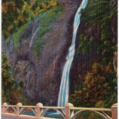
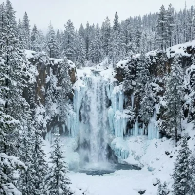
The Columbia River Gorge has 90+ waterfalls. Bridal Veil Falls is the one that passes under a 1914 stone bridge on the Historic Columbia River Highway — a 120-foot cascade dropping in two tiers over moss-covered basalt cliffs, through forest so green it looks backlit.
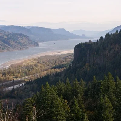
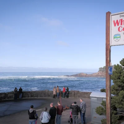
Two trails start from the parking lot. One takes you down to the base of the falls. The other takes you to a clifftop overlook of the Columbia River — with views of Beacon Rock, the Pillars of Hercules, and Hamilton Mountain across the gorge in Washington. Both trails take less than 30 minutes. Both are worth it.
What to Do
| Trail | Details |
|---|---|
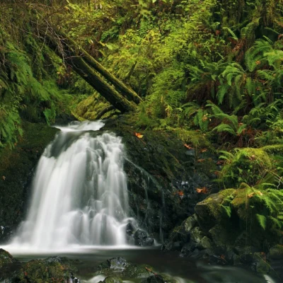
| Falls Trail | 0.6-mile out-and-back to a viewing platform at the base of the 120-foot waterfall. Unpaved, with stairs and some elevation change. Not wheelchair/stroller accessible. The falls cascade in two tiers over moss-draped basalt — best flow in spring and early summer |
| Overlook Trail | 0.5-mile paved loop along the cliff edge with fenced viewpoints of the Columbia River, Beacon Rock (an 848-foot volcanic plug across the river), the Pillars of Hercules, and the Gorge stretching east toward Hood River |
| Historic Highway | The viewpoint is accessed from the Historic Columbia River Highway — America’s first scenic highway, engineered by Samuel Lancaster in 1913–1922. The stone bridge above the falls is part of this historic road |
| Photography | The falls are photogenic year-round. Best light: morning (the falls face east). Best flow: spring snowmelt and after rain. Long-exposure shots of the two-tier cascade are a Gorge classic |
The Columbia River Gorge
| Feature | Details |
|---|---|
| The Gorge | 80 miles long, up to 4,000 feet deep — the only sea-level route through the Cascade Range. A National Scenic Area since 1986. The Columbia River is the fourth largest in North America |
| Waterfall Corridor | The Oregon side of the Gorge between Bridal Veil and Hood River has 90+ named waterfalls. Bridal Veil, Wahkeena, Multnomah, Latourell, Horsetail — all within a few miles of each other |
| Geology | The basalt cliffs are Columbia River Basalt — lava flows that erupted 15–17 million years ago. The waterfalls cascade over these layers. The Missoula Floods (15,000 years ago) carved the Gorge to its current depth |
| Nearby | Multnomah Falls (620 feet — Oregon’s tallest) is 3 miles east. Portland is 30 minutes west. The Historic Columbia River Highway connects all the major viewpoints and trailheads |
Best Time to Visit
| Season | Best For |
|---|---|
| Spring (Apr–Jun) | 🌊 Peak waterfall flow from snowmelt. Wildflowers on the Gorge walls. Green moss at its brightest. Moderate crowds before summer |
| Fall (Oct–Nov) | 🍂 Autumn color in the Gorge. Smaller crowds. Waterfalls still flowing from fall rains. Dramatic cloud formations |
| Summer (Jul–Aug) | Best weather but biggest crowds. Falls at lower volume. The Overlook Trail views are clearest. Arrive before 9 AM |
| Winter (Dec–Feb) | Rain-fed falls at good volume. Fewer visitors. Moss at its greenest. Ice possible on trails — check conditions |
Frequently Asked Questions
Is this the same as Multnomah Falls?
No — Bridal Veil Falls is a separate waterfall about 3 miles west of Multnomah Falls on the Historic Columbia River Highway. It’s smaller (120 feet vs. 620 feet) but less crowded and with a more intimate setting. Both are worth visiting.
Is parking difficult?
The parking lot is small and fills quickly on weekends. Arrive early (before 10 AM) or visit on weekdays. An Oregon State Park Pass may be required for parking.
Keep exploring: The closest neighbors are Historic Columbia River Highway State Trail (a short drive away) and Shepperd’s Dell State Natural Area (a short drive away).
🌊 120 Feet of Water. A 1914 Bridge. The Gorge Stretching to the Horizon.
Two tiers of falls over moss-covered basalt. A 30-minute walk to the base. A clifftop view of the Columbia River. And 89 more waterfalls within driving distance.
Wildlife & Nature
Bridal Veil Falls SSV — features a two-tiered, 120-foot waterfall in the Columbia River Gorge. The park’s temperate rainforest, wildflower meadows, and basalt cliffs support bald eagles, osprey, and American dippers. Wild iris and camas bloom spectacularly in spring.
Nearby Attractions
Columbia River Gorge NSA — surrounding. Multnomah Falls — 5 miles east. Portland — 25 miles west.

🐾 Dogs & Pets at Bridal Veil Falls State Scenic Viewpoint
- Pets allowed? statewide rule
- Pets are welcome in Oregon state parks and on most ocean beaches but must be leashed except in designated off-leash areas.
- Leash rule statewide rule
- Leash no longer than 6 feet required in developed park areas
- Beaches & swim areas statewide rule
- Pets are allowed on most ocean beaches under direct control; western snowy plover nesting areas restrict pets March 15 - Sept. 15; leash required on the beach at some parks (e.g. Cape Lookout)
- Cabins & lodging statewide rule
- Designated pet-friendly yurts and cabins at many parks (South Beach has 14 pet-friendly yurts, Tugman 8); maximum two dogs and/or cats; $10 per night pet fee
- Pet fees statewide rule
- $10 per night for pet-friendly yurts/cabins; no pet fee for day use or campsites
- Statewide exceptions statewide rule
- Pets prohibited at Dabney SRA, the Trail of Ten Falls at Silver Falls, and Shore Acres; off-leash areas at Stub Stewart, Willamette Mission, Elijah Bristow, Cottonwood Canyon and LaPine
Are dogs allowed at Bridal Veil Falls State Scenic Viewpoint?
Pets are welcome in Oregon state parks and on most ocean beaches but must be leashed except in designated off-leash areas. Individual parks can post stricter rules — check signage on arrival.
Rules verified July 2026 via stateparks.oregon.gov. More: Oregon state parks guide · Dog rules in all 50 states compared
Park Location
Plan your gear for Bridal Veil Falls State Scenic Viewpoint
From our editorial guides, matched to this park’s activities: