Indian Cave State Park
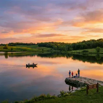
Indian Cave State Park is a 3,052-acre wilderness stretching along the towering bluffs of the Missouri River in southeastern Nebraska. Named for a dramatic sandstone overhang bearing prehistoric petroglyphs carved by Native Americans centuries ago, this park delivers a rugged, wooded landscape that feels more like the Missouri Ozarks than the Great Plains. With over 20 miles of hiking trails winding through deep ravines, 300-foot-high Loess Hills ridges, and dense hardwood forests, Indian Cave is widely regarded as Nebraska’s best state park for hiking and nature exploration.
Add to that a reconstructed 1850s frontier village, some of the finest birdwatching in the Midwest, backcountry camping shelters, and a stretch of river where Lewis and Clark once passed, and you have one of the most underrated state parks in the entire country.
Quick Facts at a Glance
| Location | Southeast Nebraska, along the Missouri River (Richardson & Nemaha Counties) |
| Park Size | 3,052 acres |
| Established | 1962 |
| Hiking Trails | 20+ miles (easy to strenuous) |
| Campsites | 134 RV sites + primitive & backcountry shelters |
| Key Feature | Prehistoric petroglyphs in sandstone cave |
| Season | Year-round (modern camping April 15 – October 31) |
| Entry | Nebraska State Park Permit required |
| Nearest City | Falls City, Nebraska (15 miles) |
History & Cultural Significance
The Petroglyphs
The park’s namesake — Indian Cave — is actually a large sandstone overhang rather than a true cave. But what makes it extraordinary are the prehistoric petroglyphs carved into its soft sandstone walls. These ancient rock carvings depict deer, buffalo, and other wildlife, offering a direct connection to the Native Americans who lived along the Missouri River centuries before European contact.
The exact age and tribal origin of the petroglyphs remain undetermined, but they are believed to be several thousand years old. Today, an ADA-accessible boardwalk leads visitors to close-up views of the carvings and panoramic views of the Missouri River landscape. Unfortunately, some of the ancient carvings have been damaged by later graffiti — a reminder of why preservation matters.
St. Deroin: A Frontier Ghost Town
Within the park boundaries lies the reconstructed village of St. Deroin, established in 1853 as part of the Nemaha Half-Breed Reservation. Named for Joseph Deroin, a fur trader of French and Otoe Indian descent, the village once served as a bustling frontier trading post along the Missouri River.
Today, several historic buildings have been reconstructed, including a one-room schoolhouse, general store, and church. The village comes alive during the park’s popular Halloween Haunt event each October, when costumed interpreters transform St. Deroin into a spooky frontier experience.
Lewis & Clark Connection
In 1804, the Lewis and Clark Expedition passed a trading post in this very area during their epic journey up the Missouri River — placing Indian Cave State Park along one of America’s most storied exploration routes.
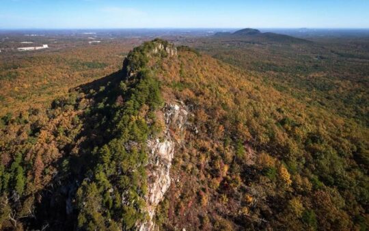
Geology: The Loess Hills
Indian Cave’s dramatically rugged terrain sets it apart from the stereotypical flat Nebraska landscape. The park sits within the Loess Hills — massive ridges of windblown silt deposited along the Missouri River Valley as glaciers retreated during the last Ice Age.
These loamy formations create 300-foot-high ridges cut by seasonal streams and deep ravines, resulting in a challenging, picturesque terrain more reminiscent of the Ozarks than the Great Plains. The cave itself was formed by the erosional action of the Missouri River, carving the sandstone overhang over thousands of years.
Trails & Hiking
With over 20 miles of trails ranging from easy nature walks to strenuous ridge climbs, Indian Cave is a hiker’s paradise. The terrain is hilly, wooded, and features cliff-like formations with ridge-top views of the Missouri River.
Trail Guide
| Trail | Distance | Difficulty | Highlights |
| Trail 1 | 1.7 miles | Moderate (hilly) | Wooded ravines, wildlife spotting |
| Trail 2 | 1.1 miles | Moderate | Ridge-top views, connection to cave |
| Trail 3 | 1.2 miles | Moderate-Strenuous | Descends from Scenic Overlook — challenging climb back |
| Trail 5 | 5.1 miles | Strenuous | Longest trail, steep sections, deep forest |
| Trail 7 | 0.3 miles | Easy | Short nature walk, family-friendly |
| Trail 8A | 0.8 miles | Easy | Flat, unpaved, accessible |
| Trail 10 | 1.1 miles | Strenuous | Steep climbs, river bluff views |
| Hardwood Trail | 14 miles | Moderate | Multi-use, longest continuous loop |
| Rock Bluff Trail | Varies | Moderate | Sandstone formations, scenic overlooks |
Backcountry Camping Shelters
Several trails connect to backcountry camping shelters, making Indian Cave one of the few Nebraska state parks where you can truly backpack overnight. These shelters provide a roof and basic structure — pack accordingly for a true wilderness experience.
Hiking tips:
- Trails are natural dirt surfaces and can be slippery after rain
- Some steep sections have significant drops — use caution with young children
- Consider bringing a GPS device or offline maps — some trail alignments may differ from printed maps
- Bring plenty of water, especially in summer when the hilly terrain is demanding
- Insect repellent is essential — mosquitoes near wet areas and horseflies can be fierce in summer
Wildlife & Birding
Indian Cave State Park is recognized as one of Nebraska’s premier birdwatching destinations, designated by Audubon as an Important Bird Area. The diverse habitats — eastern deciduous forest, native prairie, wetlands, and river corridor — support an extraordinary variety of species.
Notable Birds
Woodland Specialists (spring/summer):
- Cerulean Warbler — rare and declining canopy dweller, a highlight for serious birders
- Prothonotary Warbler — golden yellow cavity-nester found near water
- Kentucky Warbler — skulking ground-level species of mature forest
- Scarlet Tanager & Summer Tanager — brilliant red songbirds in the canopy
- Acadian Flycatcher — characteristic sound of eastern bottomland forests
- Wood Thrush — hauntingly beautiful flute-like song at dawn and dusk
Year-round Residents:
- Pileated Woodpecker — crow-sized, unmistakable rectangular excavations in dead trees
- Red-headed Woodpecker — striking tricolor plumage
- Barred Owl — “Who cooks for you?” echoing through the ravines
- Wild Turkey — large flocks throughout the park
- Bald Eagle — spectacular winter concentrations along the Missouri River
Seasonal Highlights:
- Chuck-will’s-widow — nocturnal goatsucker, heard on summer evenings
- Northern Parula & American Redstart — spring migration gems
- Wood Duck — nesting in tree cavities near water
Other Wildlife
- White-tailed Deer — abundant, especially at dawn and dusk on trails
- Beaver — active along creeks and wetland edges
- Coyote — vocal after dark, especially in fall
- Red Fox — occasionally spotted in meadow edges
Camping
Camping Options
| Type | Sites | Season | Details |
| Modern RV (Ash Grove & Hackberry Hollow) | 134 | Apr 15 – Oct 31 | 30/50 amp electric, water, showers, laundry, dump station |
| Primitive Tent Sites | Multiple | Year-round | Scenic hills, some with electric; showers accessible |
| Equestrian Camping | Available | Seasonal | Dedicated area for riders with horses |
| Backcountry Shelters | Several | Year-round | Trail-access only, basic roof shelter |
| Group Sites | Available | Seasonal | For organized groups, scouts, events |
Reservations: Can be made 3 to 180 days in advance through ReserveAmerica. Half of the electrical sites in Ash Grove and Hackberry Hollow can be booked up to 1 year in advance.
Park permit: A current Nebraska State Park Permit (annual or daily) is required for all vehicles entering the park.
Pets: Welcome in campgrounds and on most trails — leash no longer than 6 feet required.
Horseback Riding
Indian Cave is one of Nebraska’s best parks for equestrian trails, with dedicated riding trails winding through the Loess Hills terrain. A separate equestrian camping area accommodates riders and their horses. Check with park staff for current trail conditions and any seasonal restrictions.
How to Get There
Driving Directions
- From Omaha (2 hours): Take US-75 South to Nebraska Highway 67 East, which leads directly to the park entrance.
- From Lincoln (2 hours): Take US-77 South to Falls City, then Highway 67 East to the park.
- From Kansas City (1.5 hours): Take I-29 North to US-73/US-75 North, then Highway 67 West.
Nearest services: Falls City (15 miles west) offers gas, groceries, and dining. The park itself has no stores — bring all supplies.
Insider Tips
- Visit in fall (October) for peak color — the hardwood forests blaze with reds, oranges, and golds along the bluff trails
- Spring birding is world-class — May migration brings Cerulean Warblers, tanagers, and dozens of warbler species
- Don’t miss the St. Deroin Halloween Haunt — October weekends feature haunted hayrides and frontier ghost stories
- Hike to the Scenic Overlook at sunrise — Missouri River views from 300 feet above are unforgettable
- The petroglyphs are best viewed in overcast or low-angle light — harsh midday sun can wash out the carvings
- Winter Bald Eagle watching — December through February brings concentrations of eagles along the river
- Bring insect repellent in summer — mosquitoes near creek bottoms and horseflies on ridges are persistent
- Try backcountry camping — the trail shelters offer a rare Great Plains backpacking experience
- Arrive early on fall weekends — campsite reservations fill quickly during October leaf-peeping season
Best Time to Visit
| Season | Conditions | Best For |
| Spring (Apr–May) | Mild (55–75°F), wildflowers, migrating warblers | Birding, hiking, wildflower photography |
| Summer (Jun–Aug) | Hot & humid (80–95°F), lush green canopy | Camping, horseback riding, water exploration |
| Fall (Sep–Nov) | Cool (45–70°F), peak fall colors in October | Hiking (peak season!), Halloween Haunt, fall colors |
| Winter (Dec–Feb) | Cold (20–40°F), bare trees reveal geology | Bald Eagle watching, solitude, backcountry shelters |
Best overall: October is the single best month — stunning fall color, comfortable hiking temperatures, the Halloween Haunt, and fewer insects.
Nearby Attractions
- Falls City, Nebraska — historic downtown, dining, and supplies (15 miles)
- Brownville, Nebraska — Missouri River town with antique shops, wineries, and steamboat museum (20 miles north)
- Missouri River — the park offers bluff-top views; fishing access available along the riverbank
- Rock Creek Station State Historical Park — site of the Wild Bill Hickok gunfight (90 minutes northwest)
Frequently Asked Questions
Is Indian Cave a real cave?
Not in the traditional sense — it’s a large sandstone overhang or rock shelter formed by erosion from the Missouri River. However, the overhang is dramatic enough to feel cave-like, and the prehistoric petroglyphs on its walls make it one of Nebraska’s most historically significant natural features.
How difficult are the trails?
Trails range from easy 0.3-mile walks to strenuous 5+ mile routes with significant elevation changes. The terrain is surprisingly hilly for Nebraska, with 300-foot bluffs and deep ravines. Come prepared with proper footwear and water.
Can I see the petroglyphs?
Yes — an ADA-accessible boardwalk leads directly to the Indian Cave petroglyphs, allowing close-up viewing. The carvings depict wildlife and are believed to be thousands of years old.
Is camping available year-round?
Modern RV camping operates April 15 through October 31. Primitive camping and backcountry shelters are available year-round, making it possible to visit any time of year.
Do I need a park permit?
Yes — a valid Nebraska State Park Permit (annual or daily) is required for all vehicles entering the park. Permits can be purchased at the park entrance or online.
Explore More Nebraska State Parks
Indian Cave State Park is one of Nebraska’s natural treasures. Discover more in our Best State Parks in Nebraska guide, or use our Park Finder to search by activity, location, or features.