Baxter State Park
Where the Appalachian Trail Ends and Wilderness Begins
Baxter State Park is not your typical state park — it’s a 209,644-acre wilderness preserve in northern Maine where Mount Katahdin rises 5,267 feet above the dense boreal forest, where the Appalachian Trail reaches its legendary northern terminus at Baxter Peak, and where the guiding philosophy remains the original vision of Governor Percival P. Baxter: “forever wild.” There are no gift shops, no paved scenic drives, no cell towers, and no Wi-Fi. There are only mountains, moose, and miles of unbroken forest stretching to the Canadian border.
Unlike parks managed for recreation first, Baxter operates under a unique mandate: wilderness preservation takes priority over human use. This philosophy creates an experience that feels more like backcountry Alaska than New England. Vehicle size restrictions, limited daily entry, reservation-only camping, and strict “carry in, carry out” rules ensure that the park remains as wild today as when Governor Baxter donated his first parcel of land in 1931.
Mount Katahdin: Maine’s Greatest Mountain
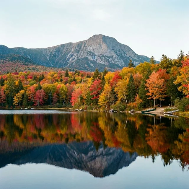
Mount Katahdin — from the Penobscot word meaning “The Greatest Mountain” — dominates the park’s southern skyline and dominates the imaginations of hikers worldwide. At 5,267 feet, it is Maine’s highest peak and the first place in the United States touched by sunrise from October through March. The mountain’s dramatic profile, featuring the knife-edge arete of the Knife Edge Trail and the vast glacial cirque of the Great Basin, makes it one of the most visually striking mountains east of the Mississippi.
Climbing Katahdin is a serious undertaking. The most popular route, the Hunt Trail (which doubles as the final 5.2 miles of the Appalachian Trail), gains approximately 4,188 feet of elevation over 5.2 miles — a round trip of 10.4 miles typically requiring 8 to 12 hours. The trail begins in dense spruce-fir forest, breaks through treeline at around 3,500 feet, and crosses exposed alpine terrain with iron rungs, boulder scrambles, and sheer drops before reaching the iconic summit sign at Baxter Peak.
The Knife Edge: New England’s Most Thrilling Trail
The Knife Edge Trail is a mile-long exposed arete connecting Baxter Peak to Pamola Peak — a razor-thin ridge with drops of over 1,500 feet on both sides. The traverse requires scrambling over jagged granite blocks with minimal handholds and relentless exposure. In clear weather, it’s one of the most exhilarating hiking experiences in the eastern United States. In wind, fog, or rain, it becomes genuinely dangerous. This trail is not for acrophobes, inexperienced hikers, or anyone uncomfortable with true exposure.
The Appalachian Trail Terminus
For the approximately 500 thru-hikers who complete the 2,190-mile Appalachian Trail each year, the weathered summit sign on Baxter Peak is the emotional culmination of a 5- to 7-month journey from Springer Mountain, Georgia. The moment of touching the iconic brown-and-white sign — often through tears — is one of the most powerful experiences in American outdoor culture.
Northbound AT hikers who have completed at least 100 continuous miles from Monson can camp at “The Birches,” a primitive campsite at Katahdin Stream limited to 12 hikers per night. All long-distance hikers must obtain a permit in person at the Katahdin Stream Campground Ranger Station before summit attempts. The AT’s final 10 miles through Baxter State Park pass through some of the most pristine boreal wilderness on the entire trail.
Beyond Katahdin: A Wilderness of Lakes and Peaks
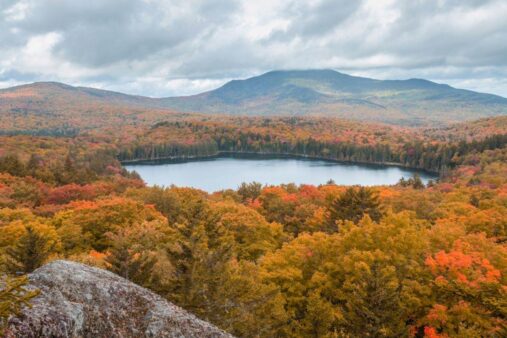
While Katahdin draws the headlines, Baxter State Park contains 46 mountain peaks and ridges, over 200 miles of hiking trails, and dozens of pristine ponds and streams — enough to fill a lifetime of exploration. South Turner Mountain offers the classic postcard view of Katahdin reflected in Sandy Stream Pond, often with moose wading in the foreground. The Owl provides a brutally steep but rewarding perspective on the Great Basin. Doubletop Mountain and The Brothers offer solitude and panoramic views far from the Katahdin crowds.
The park’s northern reaches are accessible via the Telos Road and feature remote ponds with pristine wild brook trout fishing — some of the best native trout water remaining in the eastern United States. Moose sightings are virtually guaranteed along park roads at dawn and dusk, and the park is also home to black bears, white-tailed deer, Canada lynx, pine marten, and one of the densest populations of loons in the northeastern states.
Governor Baxter’s Gift: A Unique Legacy
Baxter State Park exists because of the singular, decades-long vision of Percival P. Baxter. A former Maine governor, Baxter spent 32 years personally purchasing parcels of land surrounding Katahdin — 28 separate transactions between 1931 and 1962, totaling 201,018 acres — and donating them to the State of Maine with the legally binding condition that the land be “forever kept and remain in the Natural Wild State” and “forever kept and used for State Forest, Public Park, and Recreational Purposes.”
The Baxter State Park Authority, created by the legislature, manages the park independently from the Maine state park system. The park’s operating budget comes primarily from Baxter’s trust fund rather than state tax dollars, ensuring a level of independence that has protected the wilderness character for nearly a century.
Visitor Guide: Planning Your Katahdin Expedition
Getting There
Baxter State Park is located in north-central Maine, approximately 85 miles north of Bangor via I-95 and Routes 11/157. The park has two main entrances: the Togue Pond Gate (southern entrance, closest to Katahdin) and the Matagamon Gate (northern entrance). The nearest commercial airport is Bangor International Airport. The park’s Perimeter Road is an unpaved, narrow gravel road — RVs and trailers exceeding 22 feet are prohibited.
Reservations and Entry
A Katahdin Trailhead Pass or campsite reservation is required to access Katahdin trailheads. Day-use parking at popular trailheads is extremely limited and often fills by dawn during peak season. Reservations open 4 months in advance on a rolling basis. Walk-up spots are occasionally available but cannot be relied upon, especially for July, August, and fall foliage weekends. All visitors must register at a gatehouse.
Best Times to Visit
Summer (June–August): Peak hiking season with the longest days and warmest temperatures (60–80°F at lower elevations). Black flies can be fierce in June. July and August offer the best weather but highest demand. Fall (September–October): Spectacular foliage, cooler temperatures, fewer bugs, and thinning crowds. Katahdin may close for weather by late October. Winter (November–April): The park offers limited winter access for experienced backcountry users. Winter Katahdin ascents are serious mountaineering expeditions requiring crampons, ice axes, and winter camping experience. Spring (May): Many trails remain snow-covered and muddy. Katahdin trails typically don’t open until late May or early June.
Essential Rules
No dogs, no firearms, no drones, no generators, no personal firewood, and no trash cans — everything you bring in, you carry out. Group size is limited to 12. Children under six are generally not permitted above Katahdin’s treeline. All water from natural sources must be treated. The park operates from 6 AM to 10 PM for day visitors.
Frequently Asked Questions
How hard is it to climb Mount Katahdin?
Extremely strenuous. The Hunt Trail (AT route) gains 4,188 feet over 5.2 miles with sustained scrambling above treeline. Expect 8–12+ hours round trip. You must carry sufficient water, food, rain gear, warm layers, and a working flashlight. Katahdin has claimed lives — take it seriously regardless of the weather forecast at the trailhead.
Do I need a reservation to enter the park?
For Katahdin trailheads, yes — a Katahdin Trailhead Pass or campsite reservation is required. For other areas of the park, day-use entry is available but limited by parking capacity. During peak season, arriving at the gate before 6 AM is strongly recommended.
Is the Knife Edge safe?
In good weather with proper footwear and hiking experience, the Knife Edge is challenging but manageable for fit, experienced hikers who are comfortable with exposure. In wind, fog, rain, or ice, it becomes genuinely dangerous — there have been fatalities. Turn back immediately if conditions deteriorate. There is no easy escape route once committed to the traverse.
Will I see moose?
Moose sightings are very common in Baxter State Park, particularly along Sandy Stream Pond, Roaring Brook Road, and the park’s northern ponds. Dawn and dusk offer the best chances. Maintain at least 50 feet of distance and never approach cow moose with calves.
Can I bring my dog?
No. Dogs are prohibited in Baxter State Park under Governor Baxter’s deed of trust, which prioritizes the safety and comfort of wildlife. This applies to all areas of the park, including campgrounds, trails, and roads. Nearby private campgrounds and trails outside the park do allow dogs.