Big Spring State Park
🏆 Researched by State Park Experts — Based on Texas Parks and Wildlife Department data, verified CCC historical records, and Howard County archives for this 382-acre West Texas heritage park
There’s a particular kind of beauty to the West Texas plains that takes getting used to. It’s not the lush, obvious kind—no cascading waterfalls or towering old-growth forests here. Instead, it’s a beauty of scale and sky, of horizons that stretch so far in every direction that the Earth’s curvature starts to feel like something you can actually perceive. And rising 200 feet above those plains, a solitary mesa called Scenic Mountain offers a front-row seat to one of the most expansive views in the entire Texas state park system.
Big Spring State Park sits atop this mesa in Howard County, Texas, just outside the city of Big Spring. The 382-acre park was built by the Civilian Conservation Corps in 1934-35 using locally quarried limestone, and the CCC craftsmanship—from the hand-shaped stone blocks of the three-mile loop road to the native limestone pavilion perched on the bluff’s edge—remains so well-preserved that the park feels more like an outdoor museum of Depression-era public works than a typical day-use recreation area. For thousands of years before the CCC arrived, this promontory drew prehistoric bison hunters, Comanche raiding parties, and early frontier travelers, all of them pulled to the same vantage point by the simple fact that you can see forever from up here.
What makes Big Spring uniquely compelling isn’t what it has—it has no campground, no lake, no dramatic geological formations—but what it is: a place where three distinct ecological regions overlap (the Rolling Plains, the Edwards Plateau, and the Llano Estacado), where Depression-era craftsmanship has been perfectly preserved in the dry West Texas climate, and where the view from the top of Scenic Mountain feels like standing on the roof of the world. It’s a park that rewards the patient and the contemplative, and it’s virtually free to visit.
History: From Comanche Lookout to CCC Craftsmanship
Scenic Mountain has served as a natural landmark and lookout point for thousands of years. Archaeological evidence suggests that prehistoric peoples used the mesa as a seasonal camp, drawn by the spring at its base—the “big spring” that eventually gave the nearby city its name—and the commanding views that made this an ideal hunting and defensive position. When Comanche bands dominated the southern plains in the 18th and 19th centuries, the mountain served as a waypoint on raiding trails that stretched from New Mexico to the Texas Hill Country.
In the 1880s and 1890s, the mesa attracted cattle drivers and settlers moving west along the Texas and Pacific Railway, which established a water stop at the big spring. Some of these early travelers left their marks—literal rock carvings on the mesa’s sandstone outcrops, some dating to 1917, recording names, dates, and destinations in a frontier version of social media. These historic inscriptions are still visible along the park’s trails and add a human dimension to the geological story.
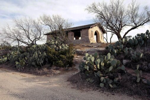
The transformation from natural landmark to state park came during the Great Depression. In 1934, the city of Big Spring deeded the mountaintop to the State of Texas, and CCC Company 1857 went to work. Over the next two years, the young men of the corps quarried limestone from the mesa itself and hand-shaped it into the buildings, walls, and roads that define the park today. Their masterpiece is the three-mile loop road that winds from the park entrance to the summit—a road so beautifully constructed from massive hand-cut stone blocks that locals call it the “Roman Road.” The CCC also built the headquarters, a commanding pavilion on the bluff’s edge, restrooms, retaining walls, and an interpretive shelter, all in the distinctive rustic style that marks CCC parks across America.
Trails & Outdoor Activities
Big Spring State Park’s trail system takes advantage of the mesa’s topography to offer surprisingly varied hiking and biking experiences for a park of its size. The trails range from a paved loop road suitable for casual walkers and cyclists to a rugged nature trail that climbs through cactus gardens and desert scrub.
| Trail | Distance | Difficulty | Highlights |
|---|---|---|---|
| Scenic Mountain Loop Road | 3.0 mi | Easy–Moderate | Paved CCC road winding to summit; 360° views; historic stone construction |
| Hike & Bike Trail | 5.0 mi | Moderate | Natural surface trail beginning/ending at park entrance; best for mountain biking |
| Nature Trail | 0.7 mi | Easy | Desert plants, cacti, interpretive signs on Chihuahuan Desert ecology |
| Sotol Stroll Loop | 0.6 mi | Easy | Sotol plants, desert wildflowers, mesa edge views |
| Outer Limits Trail | 1.2 mi | Moderate | Mesa perimeter trail; strongest views, exposed terrain |
| Vietnam Veterans Memorial Loop | 2.4 mi | Easy | Memorial markers, paved loop via Park Road 8, popular with joggers |
The Scenic Mountain Loop Road is the park’s centerpiece—a three-mile paved road that spirals up the mesa to its 2,870-foot summit. Walking or biking this road is the best way to appreciate both the CCC stonework and the progressively expanding views. At the top, a 360-degree panorama stretches across the Permian Basin in every direction: cotton fields, wind farms, oil pump jacks, and the vast emptiness of the southern plains dissolving into a haze that might be mirages or might just be Texas being Texas.
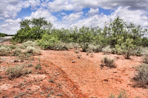
The Nature Trail is the most ecologically interesting route, traveling 0.7 miles up the hillside through a landscape dominated by prickly pear cactus, honey mesquite, redberry juniper, and shin oak. Interpretive signs identify desert plants and explain their adaptations to the arid climate. In spring, after winter rains, this trail can surprise visitors with unexpected bursts of wildflower color—desert marigolds, Indian paintbrush, and bluebonnets—that last only a few weeks before the summer heat reasserts itself.
Best Time to Visit: A Seasonal Guide
| Season | Weather | Crowds | Best For |
|---|---|---|---|
| Spring (Mar–May) | 65–85°F, occasional wind | Low to Moderate | Wildflowers (after rain), comfortable hiking temperatures, clear views, best photography light |
| Summer (Jun–Aug) | 90–105°F, intense sun | Low | Dramatic sunsets, early morning or evening visits only—midday heat is extreme |
| Fall (Sep–Nov) | 65–85°F, cooling | Low | Comfortable hiking, hawk migration, fall light on mesa, uncrowded trails |
| Winter (Dec–Feb) | 35–55°F, occasional ice | Very Low | Crisp air, exceptional visibility on clear days (50+ miles), solitude |
Spring and fall are the ideal seasons, offering comfortable temperatures and the best visibility. West Texas summers are genuinely brutal—temperatures regularly exceed 100°F with little shade on the exposed mesa, and the sun reflects off the limestone with punishing intensity. If you visit in summer, go early morning (before 9 AM) or in the evening for sunset. Winter can be beautiful on clear days, with extraordinary visibility and a stark, minimalist aesthetic, but strong north winds can make exposed sections uncomfortable.
Photography Guide
📸 Best Photo Opportunities & Settings
• Sunset from CCC Pavilion: The mesa’s western edge offers unobstructed sunset views over the Permian Basin. Arrive 30 minutes before sunset for golden hour warmth on the CCC stonework. Wind farms on the distant horizon create compelling scale. Wide-angle (16-24mm), f/11, tripod recommended.
• “Roman Road” Stone Details: Morning light raking across the hand-cut limestone blocks reveals the craftsmanship of CCC construction. Get low and shoot along the road surface for dramatic perspective. 35-50mm, f/8, side lighting.
• Prickly Pear Blooms: Spring (April–May) brings vivid yellow and magenta cactus blooms. Use a macro lens or close-focusing telephoto. Be extremely careful—cactus spines are invisible at camera distance. 85-200mm, f/4.
• 360° Panorama from Summit: Stitch multiple frames for a panorama that captures the full West Texas expanse. The summit viewpoint is best in early morning when distant features are sharpest. 35-50mm, f/8, overlap frames by 30%.
• Night Sky: Low light pollution makes Big Spring one of the best state parks for astrophotography on the western side of I-20. The Milky Way arcs dramatically overhead in summer. 14-24mm, f/2.8, 15-20 second exposure, ISO 3200-6400.
Budget Planning
| Expense | Day Visit | Half-Day Trip | Notes |
|---|---|---|---|
| Park Entry | Free | Free | No entrance fee |
| Group Pavilion Rental | $50–100 | — | Reservations through TPWD |
| Gas (from Midland/Odessa) | $15–25 | $15–25 | ~40 miles from Midland |
| Food (Big Spring, TX) | $10–20 | $10–20 | Several restaurants in town; no food service in park |
| Estimated Total | $25–45 | $25–45 | One of the most affordable state parks in Texas |
Big Spring State Park is essentially free to visit—there is no daily entrance fee, no camping fees (because there are no campsites), and no activity fees. A Texas State Park Pass ($70/year) provides entry to all 80+ Texas state parks but isn’t necessary here since admission is already free. The only costs are getting there and feeding yourself. This makes Big Spring one of the most budget-friendly state park experiences in the entire Texas system, though you’ll need to plan meals and fuel since the park has no food service or concessions.
Wildlife & Nature
Big Spring’s ecological significance lies in its position at the convergence of three distinct ecoregions: the Rolling Plains, the southern High Plains (Llano Estacado), and the Edwards Plateau. This overlap creates an unusually diverse mix of plant and animal species for an arid West Texas location, with representatives from each region sharing habitat on the mesa and surrounding slopes.
| Species | Best Season | Where to Look | Notes |
|---|---|---|---|
| 🐇 Black-tailed Jackrabbits | Year-round | Open areas along loop road, park entrance | Large-eared hares, especially active at dawn/dusk |
| 🐦 Greater Roadrunners | Year-round | Trail edges, rocky areas, parking lots | Texas icon; surprisingly fast, often seen chasing lizards |
| 🦅 Swainson’s Hawks | Mar–Oct | Soaring above mesa, open grasslands | Migration spectacle in September; look for kettles of 20+ |
| 🦌 White-tailed Deer | Year-round | Mesa slopes, Nature Trail at dawn | Small West Texas population; most active at twilight |
| 🐿️ Prairie Dogs | Year-round | Near airpark outside park boundary | Large colony visible from park; bring binoculars |
| 🦎 Texas Horned Lizards | Apr–Oct | Sandy/rocky areas along trails | State reptile of Texas; camouflaged, look carefully in morning warmth |
The park’s plant community is dominated by Chihuahuan Desert species—prickly pear cactus is everywhere, often growing to impressive size in rocky crevices where moisture collects. Honey mesquite, shin oak, and redberry juniper provide the only substantial tree cover. After good winter rains, the spring wildflower display can be remarkable, with desert marigolds, bluebonnets, and Indian paintbrush creating splashes of color against the limestone. Bird watchers should time visits to coincide with fall raptor migration (September–October), when Swainson’s hawks and other raptors ride thermals above the mesa in impressive numbers.
Safety & Hazards
| Hazard | Risk Level | Prevention |
|---|---|---|
| ☀️ Extreme Heat | Very High (summer) | Carry at least 1 liter water per person per hour. No shade on mesa top. Avoid midday hiking Jun–Aug. Heat stroke is a real risk |
| 🌵 Cactus & Thorns | Moderate | Stay on marked trails; prickly pear spines penetrate shoes. Carry tweezers. Watch where you sit |
| 🐍 Western Diamondback Rattlesnakes | Moderate | Watch step, especially on rocky trail sections. Most active Apr–Oct in morning warmth. Stay on clear paths |
| 💨 High Winds | Moderate | Mesa top is fully exposed; 40+ mph winds can occur year-round. Secure loose items, be cautious near edges |
| ⚡ Lightning | High (spring/summer) | Mesa summit is the highest point for miles. Descend immediately if thunderstorms approach—you are the tallest object up there |
The most serious safety concern at Big Spring is heat exposure. The mesa top has virtually no shade, the limestone reflects solar radiation like a mirror, and summer temperatures regularly exceed 100°F with heat indices well above that. Bring more water than you think you need, wear sun protection, and hike early or late. Lightning is a genuine hazard on the exposed summit—if you see thunderstorms developing, descend to the vehicle immediately. The mesa top is the highest point for miles in every direction.
CCC Heritage: What to Look For
Big Spring State Park is one of the best-preserved examples of CCC craftsmanship in Texas, and the dry West Texas climate has kept the 1930s-era structures in remarkably good condition. Architecture enthusiasts and history buffs should look for these specific CCC features while exploring the park:
The “Roman Road” loop drive is the crown jewel—three miles of road surface constructed from massive hand-shaped limestone blocks that could pass for ancient Roman engineering. The precision of the stonework is astonishing given that it was built by young men using hand tools during the Depression. The CCC Pavilion on the bluff’s edge features beautiful native stone construction with panoramic views, available for group reservations. The park headquarters, restrooms, and retaining walls throughout the park all exhibit the same meticulous craftsmanship, with stonework that has weathered nine decades of West Texas sun and wind without losing its structural integrity.
Visitor Information
| Detail | Information |
|---|---|
| Address | 1 Scenic Dr, Big Spring, TX 79720 |
| Phone | (432) 263-4931 |
| Hours | 8:00 AM – 10:00 PM daily |
| Entry Fee | Free |
| Camping | No camping available (day-use only) |
| Restrooms | CCC-era restroom building, maintained |
| Group Pavilion | Available for reservation; contact park office |
| Accessibility | Paved loop road is wheelchair/stroller accessible; unpaved trails are not |
Getting There & Nearby Attractions
Big Spring State Park is located at the southern edge of the city of Big Spring, Texas, easily accessible from Interstate 20. Take the US-87/Highway 87 exit south, then follow signs to FM 700 and Scenic Drive. The park entrance is well-marked and the drive from I-20 takes less than 10 minutes. From Midland/Odessa, the park is approximately 40 miles (45 minutes) east on I-20. From Lubbock, it’s about 100 miles (1.5 hours) south on US-87.
| Attraction | Distance | Drive Time | Highlights |
|---|---|---|---|
| Big Spring Heritage Museum | 3 mi | 5 min | Regional history, ranching heritage, oil industry exhibits |
| Hangar 25 Air Museum | 4 mi | 8 min | WWII and Cold War aviation, historic aircraft, Webb AFB history |
| Comanche Trail Park | 2 mi | 5 min | City park with the historic “Big Spring,” golf course, lake, and trails |
| San Angelo State Park | 90 mi | 1 hr 30 min | O.C. Fisher Lake, longhorn herd, camping, fishing |
| Monahans Sandhills SP | 70 mi | 55 min | Sand dune surfing, unique desert landscape, camping |
Don’t miss Comanche Trail Park in town, which contains the actual “big spring”—the natural spring that attracted buffalo herds, Comanche bands, and eventually settlers to this location. The spring still flows, and a short walk from the parking area leads to the pool where it emerges from the limestone. Combined with the state park, you get a complete picture of why this seemingly unremarkable spot on the West Texas plains has been a landmark for thousands of years.
Frequently Asked Questions
Can you camp at Big Spring State Park?
No. Big Spring State Park is a day-use facility only—there are no campsites, RV hookups, or overnight accommodations within the park. The park is open from 8:00 AM to 10:00 PM daily. For overnight stays in the area, the city of Big Spring has several hotels along Interstate 20. For state park camping experiences, Monahans Sandhills State Park (70 miles west) and San Angelo State Park (90 miles south) both offer developed campgrounds with hookups.
Is Big Spring State Park worth visiting?
Yes—if you appreciate CCC history, expansive views, and the stark beauty of the West Texas landscape. The park is not about lush forests or swimming holes; it’s about standing on a 200-foot mesa where prehistoric hunters, Comanche warriors, and Depression-era craftsmen all left their marks, and looking out over a horizon that seems to stretch forever. The CCC stonework is genuinely impressive, the views are unmatched in the region, and the fact that it’s completely free makes it an easy stop for anyone driving I-20 through West Texas. Plan 1–2 hours for a thorough visit.
How long does it take to visit Big Spring State Park?
A thorough visit—driving or walking the loop road, exploring the Nature Trail, examining the CCC structures, and spending time at the summit viewpoint—takes 1.5 to 2.5 hours. If you’re driving the loop road without stopping, 20-30 minutes is sufficient, but you’d miss the best parts. Add an hour if you want to hike the full 5-mile Hike and Bike Trail. The park pairs well with a visit to the Big Spring Heritage Museum and Comanche Trail Park in town for a full half-day experience.
Is there an entrance fee for Big Spring State Park?
No. Big Spring State Park has no entrance fee, making it one of the most affordable state park experiences in Texas. There are no camping fees (no camping is available), no activity fees, and no parking fees. The CCC group pavilion can be reserved through the Texas Parks and Wildlife Department for a small fee.
What wildlife can you see at Big Spring State Park?
Despite its arid setting, the park sits at the convergence of three ecoregions and supports diverse wildlife. Common sightings include black-tailed jackrabbits, greater roadrunners (the state bird icon), cottontail rabbits, ground squirrels, and various lizard species including the Texas horned lizard. White-tailed deer inhabit the mesa slopes, and a large prairie dog colony is visible near the adjacent airpark. Fall migration (September–October) brings impressive numbers of Swainson’s hawks and other raptors overhead. Rattlesnakes are present but rarely encountered on maintained trails.
What is the best time to visit Big Spring State Park?
Spring (March–May) and fall (September–November) offer the most comfortable conditions, with temperatures in the 65–85°F range and manageable winds. Spring brings the possibility of wildflower displays after winter rains. Summer visitors should plan for extreme heat—temperatures regularly exceed 100°F on the exposed mesa, and there is virtually no shade. Winter can be pleasant on calm, clear days, with exceptional visibility reaching 50+ miles, but strong north winds can make the mesa top uncomfortably cold.
What did the CCC build at Big Spring State Park?
CCC Company 1857 built virtually everything you see in the park during 1934-35, using locally quarried limestone. Their work includes the three-mile “Roman Road” loop drive (constructed from hand-shaped stone blocks), the park headquarters, a scenic pavilion on the bluff’s edge, restrooms, retaining walls, and an interpretive shelter. The dry West Texas climate has preserved this Depression-era craftsmanship in remarkable condition. Big Spring is considered one of the finest surviving examples of CCC park construction in Texas.
🏜️ Ready to Explore Big Spring State Park?
Stand atop Scenic Mountain where Comanche warriors once scanned the horizon, and see the West Texas plains stretch to infinity in every direction. One of the most affordable—and most underrated—state park experiences in Texas.