Palouse Falls State Park
Washington’s Official Waterfall: A 200-Foot Plunge Into Ice Age History
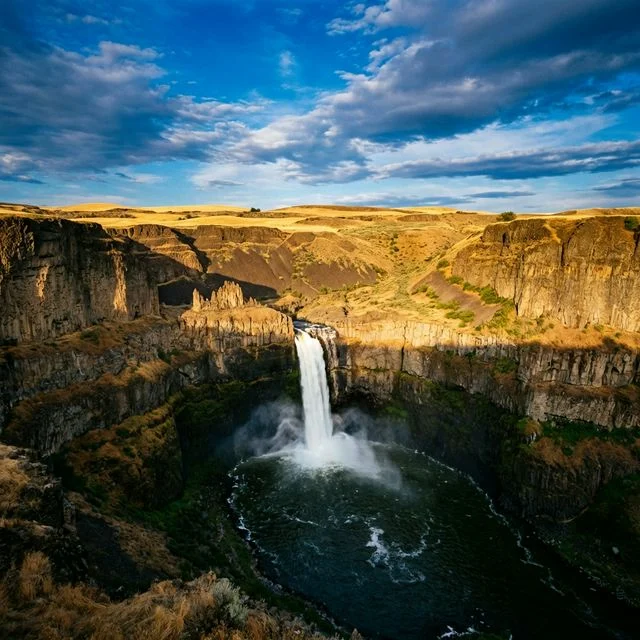
In the remote wheat fields of eastern Washington, where the landscape stretches flat and golden to every horizon, the earth suddenly rips open. Without warning, the Palouse River plunges 200 feet into a churning basalt canyon carved by some of the most catastrophic floods in Earth’s history. This is Palouse Falls — Washington State’s official state waterfall and one of the most dramatically beautiful geological features in the Pacific Northwest.
Palouse Falls State Park is a compact 94-acre treasure that punches far above its weight. The falls cascade into a canyon carved from Columbia River flood basalts — volcanic rock millions of years old — that was violently reshaped during the Missoula Floods over 13,000 years ago. These Ice Age megafloods, among the largest floods in geological history, scoured the landscape and created the dramatic amphitheater that frames the waterfall today. The canyon’s sheer scale — nearly 400 feet deep — dwarfs the current river, a haunting reminder of the unimaginable forces that shaped this land.
🌊 The Waterfall
| Feature | Details |
|---|---|
| Height | ~200 feet (61 meters) |
| Type | Plunge waterfall into basalt bowl |
| Status | Washington State’s official waterfall (designated 2014) |
| Best Flow | Spring (March–May) — snowmelt and rainfall maximize volume |
| Canyon Depth | ~400 feet |
| Rock Type | Columbia River flood basalt (millions of years old) |
The waterfall is visible from multiple designated overlooks near the parking area, each offering a different perspective. The Fryxell Overlook provides the most panoramic view, where you can see the full cascade, the churning plunge pool, and the narrow basalt canyon stretching downstream. Sunrise and sunset produce the most dramatic lighting conditions, with golden light illuminating the basalt walls and mist rising from the falls.
🪨 Geology: The Missoula Floods
The story of Palouse Falls begins with one of the most extraordinary events in Earth’s recent geological history. During the last Ice Age, a massive glacial lake — Glacial Lake Missoula — repeatedly formed behind an ice dam in what is now Montana. When the dam broke, an unimaginable volume of water rushed across eastern Washington at speeds up to 65 miles per hour, carving the landscape known today as the Channeled Scablands.
These Missoula Floods — which occurred dozens of times between 15,000 and 13,000 years ago — stripped away topsoil, carved deep coulees, and exposed ancient basalt bedrock laid down by volcanic eruptions millions of years earlier. Palouse Falls is one of the last active waterfalls remaining along the path of these ancient floods. The canyon’s enormous size relative to the modest Palouse River was one of the first clues that helped geologist J Harlen Bretz propose his then-controversial theory of catastrophic flooding in the 1920s.
🥾 Viewing Areas & Trails
| Area | Distance | Difficulty | Highlights |
|---|---|---|---|
| Main Overlook | ~200 ft from parking | Easy (ADA) | Direct view of the 200-ft falls and basalt canyon |
| Fryxell Overlook | ~0.3 mi | Easy | Panoramic canyon vistas, interpretive signs about Ice Age floods |
| Upper Canyon Viewpoint | ~0.2 mi | Easy | Views upstream of the Palouse River approaching the falls |
⚠️ Important Safety Notice: All trails leading into the canyon and to the base of the falls are permanently closed as of 2022. These unofficial “social trails” were shut down after numerous injuries and fatalities on the steep, loose basalt slopes. Visitors must stay within designated viewing areas at all times. The overlooks provide spectacular views — going beyond the barriers is illegal and extremely dangerous.
📸 Photography Tips
- Golden Hour — Sunrise and sunset produce the best lighting. The east-facing canyon wall glows warm at sunset.
- Spring Flow — March–May offers the most powerful water flow for dramatic photos.
- Stars — With virtually zero light pollution, Palouse Falls is an exceptional astrophotography location. The Milky Way arcs over the canyon in summer.
- Wide Angle — Bring a wide-angle lens to capture both the falls and the massive canyon walls.
- Tripod — Essential for long exposures (silky water effect) and astrophotography.
🏕️ Camping & Visitor Information
| Item | Details |
|---|---|
| Park Size | 94 acres |
| Entry Fee | Discover Pass required ($10/day or $30/year) |
| Day-Use Hours | 6:30 AM – dusk (summer) / 8:00 AM – dusk (winter) |
| Camping | Limited tent-only sites, first-come first-served ($10–15/night) |
| Amenities | Vault toilets, picnic tables, parking lot |
| Water | Available April – October only |
| Cell Service | None — download maps and directions before arriving |
| Pets | Allowed on leash |
📅 Seasonal Guide
| Season | Dates | Highlights | Considerations |
|---|---|---|---|
| Spring | Mar–May | Peak water flow, most dramatic falls, wildflowers on canyon rim | Can be windy; parking fills on weekends |
| Summer | Jun–Aug | Longest days, astrophotography, warm temperatures | Reduced water flow; very hot (100°F+); no shade |
| Fall | Sep–Nov | Golden wheat fields, fewer crowds, mild temperatures | Water flow decreasing; shorter days |
| Winter | Dec–Feb | Frozen mist on canyon walls, solitude, occasional ice formations | Roads may be icy; limited hours; water turned off |
💰 Budget Planner
| Item | Cost | Notes |
|---|---|---|
| Discover Pass (Day) | $10 | Cash or check only at park; buy online in advance |
| Discover Pass (Annual) | $30 | Valid at all Washington state parks |
| Primitive Campsite | $10/night | First-come, first-served; tent only |
| Standard Campsite | $15/night | First-come, first-served |
| Gas (from Spokane) | ~$20–30 | ~115 miles each way; no gas stations nearby |
⚠️ Essential Tips
- Bring everything you need — The park is extremely remote. No food, gas, or supplies within 30+ miles.
- Buy your Discover Pass in advance — Electronic payments are NOT accepted at the park. Buy online or bring cash/check.
- No cell service — Download GPS directions, maps, and any needed information before you lose signal.
- Stay behind barriers — Canyon rim trails are permanently closed. Multiple fatalities have occurred.
- Sun protection — Virtually no shade; bring sunscreen, hat, and ample water in summer.
- Watch for rattlesnakes — Eastern Washington basalt habitat is home to rattlesnakes.
- Wind — The exposed canyon rim can be extremely windy, especially in spring.
❓ Frequently Asked Questions
How tall is Palouse Falls?
Palouse Falls is approximately 200 feet (61 meters) tall, making it one of the most impressive waterfalls in Washington State. It was designated as Washington’s official state waterfall in 2014. The falls plunge into a basalt canyon that is nearly 400 feet deep.
Can I hike to the base of Palouse Falls?
No — all trails leading into the canyon and to the base of the falls are permanently closed. These social trails were officially closed in 2022 due to numerous injuries and fatalities on the unstable basalt slopes. Visitors must stay within designated viewing areas, which provide excellent views of the falls from multiple angles.
When is the best time to visit Palouse Falls?
Spring (March–May) is the best time, when snowmelt and rainfall produce the most powerful water flow. Summer offers the best weather for astrophotography but reduced water flow and extreme heat (100°F+). The park is open year-round, but spring weekends can be very crowded — visit on a weekday if possible.
Do I need a Discover Pass?
Yes — a Washington State Discover Pass is required for vehicle access. Day passes cost $10 and annual passes cost $30. Buy your pass online before arriving, as the park only accepts cash or check, and there’s no cell service to purchase one digitally on-site.
How were Palouse Falls formed?
Palouse Falls was created by the Missoula Floods — cataclysmic Ice Age floods that occurred between 15,000 and 13,000 years ago. When glacial ice dams broke in Montana, massive walls of water scoured eastern Washington, carving deep canyons through ancient Columbia River basalt. The falls are one of the last active waterfalls along the path of these prehistoric megafloods.

