Quabbin Reservoir
🌤 Weather at Quabbin Reservoir by season
| Spring | Summer | Fall | Winter |
|---|---|---|---|
| 24–68 °F | 54–82 °F | 30–73 °F | 15–38 °F |
Each range runs from the coldest monthly average low to the warmest monthly average high in that season (1991-2020 climate normals), measured at Belchertown, 8 mi away, elevation 550 ft. Conditions at the park can differ from the station, especially where elevation differs — check a forecast before you go.

🏆 MA’s LARGEST Body of Water — 412-billion-gallon reservoir created by drowning 4 entire towns — Boston’s water supply and an ecological wonder
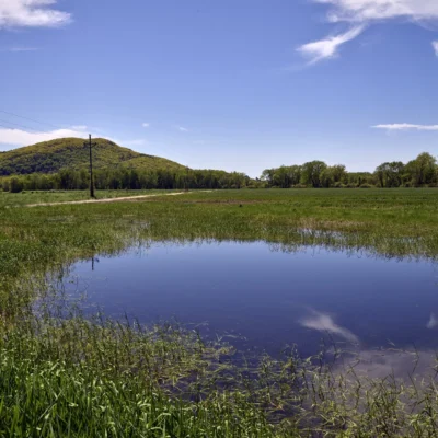
Quabbin Reservoir is Massachusetts’ largest body of water — 412 billion gallons created in the 1930s by damming the Swift River and flooding the four towns of Dana, Enfield, Greenwich, and Prescott. Over 2,500 residents were displaced, 7,500 graves were relocated, and every building was demolished or moved. Today, the 81,000-acre watershed is one of the most pristine ecosystems in the eastern United States — home to bald eagles, moose, black bears, and bobcats in a landscape that looks like northern Maine transplanted to central Massachusetts.
Visitor Information
| Detail | Information |
|---|---|
| Location | Central MA (multiple towns) |
| Size | 81,000 acres watershed! |
| Entry Fee | Free (some areas restricted) |
| Water | 412 BILLION gallons! |
| History | 4 towns drowned, 2,500 displaced, 7,500 graves moved |
Frequently Asked Questions
Can you see remains of the drowned towns?
During drought years, cellar holes, roads, and foundations of the four lost towns emerge as the water level drops. The Quabbin Visitor Center in Belchertown has exhibits about the communities that were sacrificed for Boston’s water supply.
About Quabbin Reservoir
Quabbin Reservoir is one of the largest unfiltered public water supplies in the United States — a 39-square-mile artificial lake that provides drinking water to 2.5 million people in the Boston metropolitan area. Created in the 1930s by flooding four entire towns (Dana, Enfield, Greenwich, and Prescott), it’s the largest body of water in Massachusetts. Bald eagles have returned to nest here — the first successful breeding in Massachusetts in over a century.
Things to Do
Hiking on 60+ miles of trails, fishing (trophy-class lake trout and landlocked salmon), birdwatching for bald eagles and loons, and visiting the Quabbin Visitor Center to learn about the four “lost towns.” Shore fishing requires a permit; boats are restricted. One of the wildest places in Massachusetts.
Nearby parks: If you have extra time, Lake Wyola State Park is a short drive away, and Wendell State Forest is a short drive away.
Wildlife & Nature
Quabbin Reservoir — 39 square miles — is one of the largest unfiltered water supplies in the US, providing drinking water to 2.5 million people in metropolitan Boston. To create the reservoir (1938), four entire towns were dismantled and flooded (Dana, Enfield, Greenwich, Prescott) — a Massachusetts tragedy. The reservoir’s protected watershed supports bald eagles (reintroduced here in 1982, the first successful nesting in MA in over a century), moose, black bears, and loons.
Nearby Attractions
Belchertown — adjacent. Quabbin Visitor Center — on-site. Amherst — 20 miles west.

Park Map
Plan your gear for Quabbin Reservoir
From our editorial guides, matched to this park’s activities:
Top Tours & Activities Near Massachusetts
 from $550
 from $45
 from $42