
🚴 60 Miles Through the Driftless — Where the Glaciers Never Came and the Bluffs Still Stand — Blufflands State Trail (Root River Segment) in southeastern Minnesota, paved bike trail through the Driftless Area, Lanesboro to Houston via Preston and Rushford, limestone bluffs rising 300+ feet, Root River valley, Amish country, small-town Minnesota, trout streams, one of America’s best rail-trails — Fillmore/Houston Counties, MN
The glaciers that flattened the rest of Minnesota missed this corner. Southeastern Minnesota’s Driftless Area was never bulldozed by ice — so the landscape looks nothing like the rest of the state. Instead of flat prairie: 300-foot limestone bluffs, deep river valleys, cold trout streams, and hardwood forests that belong more in the Appalachians than the Upper Midwest.
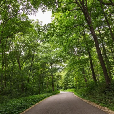
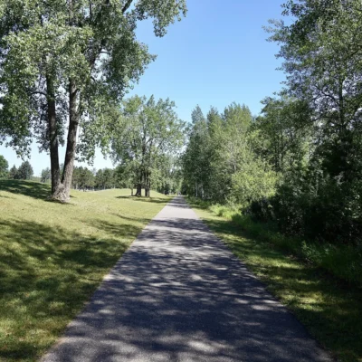
The Root River State Trail — the signature segment of the Blufflands system — runs 60 miles through the heart of it. Paved, flat (it follows an old railroad grade), and connecting a string of small towns where Amish buggies share the road with cyclists and the pie shops never close.
The Trail
| Segment | Details |
|---|---|
| Root River Trail | 42 miles of paved trail from Fountain to Houston, following the Root River through the Driftless landscape. Flat grade (former railroad). Connects Fountain, Lanesboro, Whalan, Peterson, Rushford, and Houston |
| Harmony-Preston Valley | 18 miles of paved trail from Harmony to Preston through Camp Creek and Watson Creek valleys. Connects to the Root River Trail at Preston. Amish farmland and bluff views |
| Lanesboro | The trail’s hub town. Population ~750. Bed-and-breakfasts, bike shops, canoe outfitters, theater, and restaurants. Called “the B&B capital of Minnesota.” The trail runs right through Main Street |
| Surface & Grade | Paved asphalt on a former railroad bed. Virtually flat with gentle grades. Suitable for all ages and abilities. ADA-accessible sections. Wheeled-vehicle permit required ($6/day, $25/year) |
The Driftless Area
| Feature | Details |
|---|---|
| No Glaciers | The Driftless Area — roughly 24,000 square miles spanning MN, WI, IA, and IL — was never covered by glacial ice. While glaciers flattened everything around it, this region kept its ancient topography: bluffs, valleys, springs, and caves |
| Limestone Bluffs | 300–500 foot bluffs of Ordovician limestone line the Root River valley. 450 million years old. Exposed by the river cutting through the plateau. The bluffs give the “Blufflands” trail system its name |
| Trout Streams | Cold groundwater springs feed the Root River and its tributaries — some of the best trout fishing in the Midwest. Brown trout, brook trout, and rainbow trout in limestone-filtered water |
| Amish Community | The Harmony-Canton-Lanesboro area has one of the largest Amish communities in Minnesota. Amish farms, furniture shops, and buggy traffic are part of the landscape. Respect: no photos of Amish people without permission |
Best Time to Visit
| Season | Best For |
|---|---|
| Fall (Sep–Oct) | 🍂 THE season. Hardwood bluffs blazing with color. Cool cycling weather. Fewer bugs. The Driftless in full autumn glory. Apple orchards and harvest festivals |
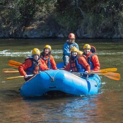
| Summer (Jun–Aug) | ☀️ Peak cycling. Canoeing the Root River. Trout fishing. Amish farm stands with produce. Long days and warm evenings in Lanesboro. Tubing on the river |
| Spring (Apr–May) | Wildflowers on the bluffs. Morel mushroom season. Trout season opening. River running high. Trail opening after winter |
| Winter (Dec–Feb) | Cross-country skiing and fat biking on groomed trail sections. Snowshoeing. Cold — this is Minnesota. The bluffs in snow are dramatic |
Frequently Asked Questions
What is the Driftless Area?
The region the glaciers missed. While ice sheets flattened the rest of the Midwest, this 24,000-square-mile area spanning four states kept its original topography — bluffs, valleys, springs, and caves that look nothing like the surrounding flatland. “Drift” is the geological term for glacial debris; “driftless” means none was deposited here.
Do I need a trail pass?
Yes — a Wheel Pass is required for anyone 16+ using wheeled vehicles (bikes, inline skates) on the trail. Daily pass $6, annual pass $25. Available at trail offices, local businesses, and online through Minnesota DNR.
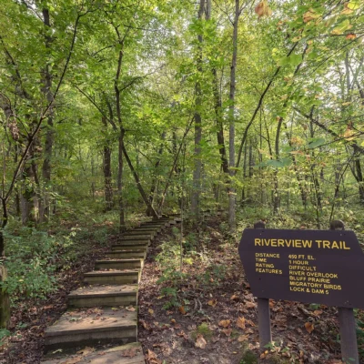
Nearby state parks: If you have extra time, Blufflands State Trail: Harmony-Preston Valley Segment is a short drive away, and Forestville / Mystery Cave State Park is a short drive away.
🚴 60 Miles Through the Corner the Glaciers Missed
300-foot limestone bluffs. Cold trout streams. Amish buggies on the road. Pie shops in towns of 750. The flattest state in America hides a landscape that looks like the Appalachians — and a paved trail runs right through it.
Wildlife & Nature
Root River Trail — 60+ miles through the bluff country — is one of the premier bike trails in the Midwest. The trail follows the Root River through limestone bluffs, forests, and small towns. Bald eagles nest along the river. Brown trout inhabit the cold tributaries. Wild turkeys cross the trail.
Nearby Attractions
Lanesboro — the trail hub — has the Commonweal Theatre, B&Bs, and canoe rentals. Whalen — has the bridge. Houston — eastern terminus. Forestville/Mystery Cave SP — 10 miles south.

🐾 Dogs & Pets at Blufflands State Trail: Root River Segment
- Pets allowed? statewide rule
- Pets are welcome in Minnesota state parks and recreation areas as long as they are leashed and personally attended at all times.
- Leash rule statewide rule
- Leash six feet or shorter (or portable enclosure) required at all times.
- Beaches & swim areas statewide rule
- Only service animals are allowed in beach areas — pets are prohibited on swim beaches statewide.
- Cabins & lodging statewide rule
- Only service animals are allowed in state park lodging, camper cabins, yurts and tipis — no pet-friendly cabin program.
- Statewide exceptions statewide rule
- Emotional support/therapy animals do not qualify as service animals and are prohibited from park buildings.
Are dogs allowed at Blufflands State Trail: Root River Segment?
Pets are welcome in Minnesota state parks and recreation areas as long as they are leashed and personally attended at all times. Individual parks can post stricter rules — check signage on arrival.
Rules verified July 2026 via dnr.state.mn.us. More: Minnesota state parks guide · Dog rules in all 50 states compared
Park Location
Plan your gear for Blufflands State Trail: Root River Segment
From our editorial guides, matched to this park’s activities:
Top Tours & Activities in Minnesota
 from $79
 from $110
 from $195