Palo Duro Canyon State Park
Where 250 Million Years of Geology Blaze in the Grand Canyon of Texas
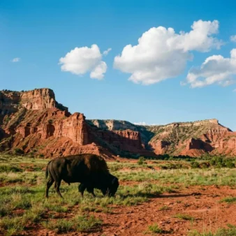
Palo Duro Canyon State Park is the second largest canyon system in the United States — a staggering geological wound in the otherwise pancake-flat Texas Panhandle that stretches 120 miles long, up to 20 miles wide, and plunges 800 feet deep into the earth, exposing 250 million years of geological history in its vividly banded walls of red, orange, maroon, cream, and lavender. Drive the arrow-straight highways of the Llano Estacado in any direction and you see nothing but treeless prairie stretching to infinity. Then, without warning, the earth opens beneath you, and you are staring into a chasm so vast, so deeply colored, and so profoundly unexpected that the Spanish explorers who first encountered it in 1541 gave it the only name that made sense: Palo Duro — “hard wood” — for the juniper trees clinging to its impossible walls.
This is the Grand Canyon of Texas, and while it cannot match Arizona’s elder sibling in sheer depth, it rivals it in chromatic intensity and surpasses it in accessibility — you can drive to the canyon floor, camp beside its red walls, ride horses through its mesquite valleys, and hike to its most iconic formation in a single afternoon. It is also one of the most culturally significant landscapes in the American West: the canyon served as the final stronghold of the Comanche, Kiowa, and Southern Cheyenne during the Red River War of 1874, and the 1876 establishment of Charles Goodnight’s JA Ranch in the canyon marked the birth of the Texas Panhandle cattle industry.
The Lighthouse: Icon of the Panhandle
The Lighthouse is Palo Duro Canyon’s signature formation — a towering hoodoo rising over 300 feet from the canyon floor, its distinctive mushroom shape formed when a cap of harder Ogallala Formation caliche protected the softer red Quartermaster Formation beneath from millennia of erosion that devoured the surrounding rock. The result is a natural skyscraper that has become the single most photographed landmark in the Texas Panhandle and the symbol of the state park system itself.
The Lighthouse Trail (5.7 miles round trip, ~500 feet elevation change) is the park’s most popular hike and one of the finest moderate trails in Texas. The route traverses the canyon floor through mesquite and juniper scrubland, crosses seasonal creek beds, and passes through several distinct geological layers before the Lighthouse appears in the distance — growing progressively more dramatic and improbable as you approach. The final scramble to the base of the formation involves a short, steep climb up loose rock and requires careful footing, but the reward is commanding: the Lighthouse looming overhead, the canyon spreading in every direction in a tapestry of sedimentary color, and a silence so complete you can hear the wind carving the next millimeter of stone.
Start early — the trail offers minimal shade, and summer temperatures regularly exceed 100°F on the canyon floor. Bring at least one liter of water per person per hour, wear a hat, and apply sunscreen liberally. The trailhead parking lot fills quickly on weekends and holidays.
Geology: Reading 250 Million Years in Living Color
The walls of Palo Duro Canyon are a textbook of geological history — and unlike most geological formations, the story here is told in vivid, unmistakable color. Four distinct geological periods are on display in the canyon’s layered walls, each identifiable by its characteristic hue:
Quartermaster Formation (Permian, ~250 million years old): The canyon’s lowest and oldest layer — deep brick-red and maroon mudstones and siltstones deposited in a vast, shallow sea and tidal flat environment. This blood-red rock forms the canyon floor and lower walls, giving Palo Duro its most distinctive and dramatic coloring. The red comes from iron oxide — rust, essentially — coating every grain of sand.
Tecovas Formation (Triassic, ~220 million years old): A striking band of lavender, purple, and grey shales and mudstones that creates an unmistakable horizontal stripe across the canyon walls. The Tecovas was deposited in swamps and floodplains when the region was far wetter and more tropical, home to phytosaurs, metoposaurs, and other prehistoric reptiles whose fossils have been found in this layer.
Trujillo Formation (Triassic, ~210 million years old): A layer of tan and buff-colored sandstone and conglomerate, deposited by ancient rivers in a drier landscape. This harder rock forms many of the canyon’s ledges, shelves, and overhangs — and its resistance to erosion is partly responsible for the dramatic stepped profile of the canyon walls.
Ogallala Formation (Miocene, ~10 million years old): The canyon’s caprock — a relatively young layer of caliche, sand, and gravel deposited by ancient streams flowing east from the rising Rocky Mountains. This hard, resistant layer forms the flat surface of the Llano Estacado above the canyon and protects the softer formations below from erosion. Where the Ogallala erodes away, the canyon grows; where it persists, it caps hoodoos like the Lighthouse.
The canyon itself was carved by the Prairie Dog Town Fork of the Red River, which began downcutting through these layers approximately 1 million years ago. The process is ongoing — every heavy rainstorm removes another microscopic layer of ancient sediment and carries it east toward the Mississippi Delta.
Wildlife and Ecology: Where Plains Meet Canyon
The canyon creates a dramatic ecological transition zone — the flat, arid Llano Estacado above gives way to mesquite woodlands, juniper forests, cottonwood-lined creek beds, and even patches of hackberry and wild plum on the canyon floor. This diversity of habitat supports a surprisingly rich wildlife community: mule deer browse the canyon rim at dawn, white-tailed deer inhabit the canyon bottom, aoudad sheep (Barbary sheep, introduced from North Africa in the 1950s) scramble the rock faces with astonishing agility, and wild turkey forage beneath the mesquite.
The canyon shelters a significant population of Texas horned lizards — the beloved “horny toads” that have become increasingly rare across much of their former range. Golden eagles soar the thermals above the rim, roadrunners sprint the canyon floor, and during spring and fall migration, the canyon funnels thousands of raptors along its corridor. At night, the canyon comes alive with kit foxes, ringtails, porcupines, and an extraordinary diversity of bats that roost in the overhangs and rock crevices.
History: Comanche Stronghold to Cattle Kingdom
Palo Duro Canyon’s history is among the most dramatic in the American West. For centuries, the canyon served as a seasonal refuge for Comanche bands who wintered in its sheltered depths — protected from the howling norther winds of the open plains, with water, grass for horse herds, and abundant game. The canyon’s strategic value was immense: invisible from the flat plains above, defensible, and provisioned with everything a mobile horse culture needed to survive.
On September 28, 1874, Colonel Ranald S. Mackenzie and the 4th U.S. Cavalry discovered the Comanche encampment in Palo Duro Canyon and launched a dawn raid in what became the Battle of Palo Duro Canyon — the decisive engagement of the Red River War. Mackenzie’s troops descended the canyon walls, scattered the encampment, and — in the act that sealed the campaign — captured and slaughtered over 1,400 Comanche horses and mules. Without their horse herds, the Comanche, Kiowa, and Southern Cheyenne bands had no means of sustaining their nomadic way of life, and over the following months, band after band surrendered at Fort Sill. The Battle of Palo Duro Canyon effectively ended the free-roaming era of the Southern Plains peoples.
Just two years later, in 1876, legendary cattleman Charles Goodnight drove his first herd of cattle into the canyon and established the JA Ranch in partnership with Irish financier John George Adair — creating the first cattle ranch in the Texas Panhandle and launching the region’s transformation from Comanche homeland to cattle kingdom. The original JA Ranch eventually encompassed over 1.3 million acres.
TEXAS Outdoor Musical
Each summer from June through August, the Pioneer Amphitheatre on the canyon floor hosts “TEXAS” — the longest-running outdoor musical drama in the United States, performed annually since 1966. The production tells the story of Texas Panhandle settlers through song, dance, and spectacle against the backdrop of the actual canyon walls — which serve as a 600-foot-tall natural stage set that no theater architect could match. The show features professional performers, live horses, fireworks, and a thundering sound system that fills the canyon. Pre-show barbecue dinners are available. Tickets should be reserved well in advance for peak summer dates.
Visitor Guide: Planning Your Canyon Adventure
Getting There
Palo Duro Canyon State Park is located 12 miles east of Canyon, Texas, and approximately 25 miles south of Amarillo via TX-217. Amarillo’s Rick Husband International Airport provides the nearest commercial air service. The park entrance includes a dramatic descent down the canyon wall via a switchback road — your first view of the canyon from the rim is genuinely breathtaking.
Fees and Hours
Park entry is $8 per adult (13+), free for children 12 and under. The park is open 7:30 a.m. to 10 p.m. daily. Advance day-use reservations are highly recommended — the park frequently reaches capacity during weekends, holidays, and the TEXAS musical season, and visitors without reservations may be turned away. Reservations can be made at texasstateparks.org.
Camping
The park offers over 100 campsites ranging from primitive backpacking sites ($12/night) to developed tent sites ($20/night) and RV sites with water and electricity ($30/night). Three CCC-era stone cabins ($110/night) offer a more comfortable experience with heating/AC and period architecture. Glamping options are also available. All camping reservations should be made well in advance, particularly for fall weekends and spring break.
Best Times to Visit
October – November: Ideal temperatures (60–80°F), cottonwood trees blazing golden yellow on the canyon floor, clear skies, manageable crowds. March – May: Wildflower season, moderate temperatures, occasional thunderstorms that create dramatic canyon lighting and temporary waterfalls. June – August: Hot (regularly 100°F+) but the TEXAS musical runs nightly — start hikes at dawn. December – February: Cold and occasionally snowy, but the canyon is hauntingly beautiful with snow dusting the red rock.
Frequently Asked Questions
Is Palo Duro Canyon really comparable to the Grand Canyon?
They are fundamentally different experiences. The Grand Canyon is deeper (over 5,000 feet vs. 800 feet) and geologically older, but Palo Duro Canyon is far more accessible — you can drive to the floor, camp in the canyon, and hike to formations like the Lighthouse in a few hours. The chromatic intensity of Palo Duro’s layered red, lavender, and cream walls is genuinely stunning and rivals any canyon in the West for sheer beauty.
How hard is the Lighthouse Trail?
Moderate — the 5.7-mile round trip is mostly flat with a short, steep scramble at the end. The challenge is primarily heat and sun exposure, not technical difficulty. Start early (before 8 a.m. in summer), bring ample water (1 liter per person per hour minimum), and wear sun protection. The trail is not wheelchair accessible, and mountain bikes are not permitted past a certain point.
Do I need reservations to visit?
Not technically required for midweek visits, but strongly recommended for all visits. The park caps daily visitors and regularly turns away cars at capacity during weekends, holidays, and the TEXAS musical season. Book day-use reservations at texasstateparks.org — there’s no cost beyond the entry fee.
What other trails are worth doing?
Beyond the Lighthouse Trail, the Capitol Peak Trail (5.3 miles round trip) offers panoramic rim views, the Givens, Spicer & Lowry Running Trail is excellent for trail running and mountain biking (5.75 miles), and the Rock Garden Trail (2.3 miles) passes Spanish Skirts — a dramatic formation of red rock eroded into flowing, fabric-like patterns. Over 30 miles of trails total offer options for every ability level.
Is the TEXAS musical worth seeing?
Absolutely — the canyon itself as a backdrop is worth the price of admission. The show is family-friendly, features professional performers, and the combination of live performance, fireworks, and a 600-foot canyon wall “set” creates an experience unlike any other outdoor venue in America. Arrive early for the pre-show barbecue and enjoy sunset painting the canyon walls before the performance begins.