🌋 Camp on a Bluff Above Cook Inlet — With Three Active Volcanoes Across the Water — Captain Cook State Recreation Area on the Kenai Peninsula, Alaska, northernmost road-accessible point on Kenai Spur Highway, 53-site campground on bluffs above Cook Inlet, views of Mount Redoubt, Iliamna, and Spurr volcanoes, beachcombing for agates, Swanson River fishing, Stormy Lake, beluga whales, hidden gem — Kenai Peninsula Borough, AK
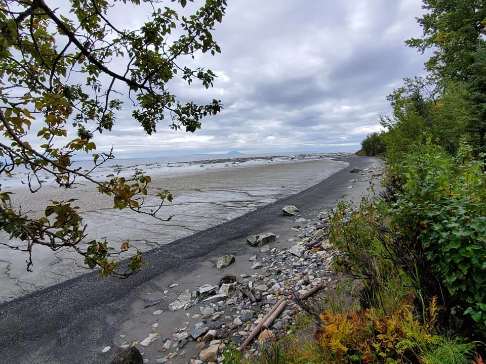
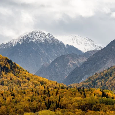
At the end of the road on the Kenai Peninsula, where the pavement stops and Cook Inlet stretches to the horizon, three volcanoes line up across the water. Mount Redoubt. Mount Iliamna. Mount Spurr. All active. All snow-capped. All visible from your campsite on the bluffs above the inlet.
Captain Cook State Recreation Area sits at the northernmost point you can drive to on the Kenai Spur Highway — 25 miles past Kenai, 14 miles past Nikiski, and beyond everyone headed to the Kenai River. That’s the point. While every other campground on the peninsula fills up with salmon fishermen, this one stays half-empty. The views are better. The crowds are gone.
What to Do
| Activity | Details |
|---|---|
| Camping | Discovery Campground — 53 wooded, RV-friendly sites on the bluffs above Cook Inlet. Picnic tables, fire pits, vault toilets. Natural foliage provides privacy between sites. The last campground on the road — and one of the quietest on the peninsula |
| Volcano Viewing | On clear days, three active volcanoes are visible across Cook Inlet: Mount Redoubt (10,197 ft, last erupted 2009), Mount Iliamna (10,016 ft), and Mount Spurr (11,070 ft, last erupted 1992). The sunset behind the volcanic skyline is extraordinary |
| Beachcombing | The Cook Inlet shoreline produces agates, jasper, and fossils. Low tide exposes wide beaches of gravel and sand. Beach access via trails from the bluffs. DANGER: The mudflats are extremely dangerous — Cook Inlet has 30+ foot tides, and the mud can trap you like quicksand |
| Fishing | Swanson River within the park — rainbow trout and silver (coho) salmon. Stormy Lake nearby — stocked rainbow trout and Arctic char. A quieter alternative to the crowded Kenai and Russian rivers |
| Wildlife | Moose browsing through the campground (common). Black bears in the forest. Bald eagles along the inlet. Beluga whales and harbor seals visible from the bluffs during summer. Waterfowl on Stormy Lake |
Cook Inlet
| Feature | Details |
|---|---|
| The Inlet | Cook Inlet is a 180-mile arm of the Pacific Ocean extending from the Gulf of Alaska to Anchorage. Named for Captain James Cook, who explored it in 1778 searching for the Northwest Passage. The inlet has some of the most extreme tides in the world |
| The Tides | Tidal range up to 30+ feet — among the largest on Earth. The mudflats exposed at low tide are notoriously dangerous. The mud has the consistency of wet concrete and can trap a person in minutes. Do NOT walk on the mudflats |
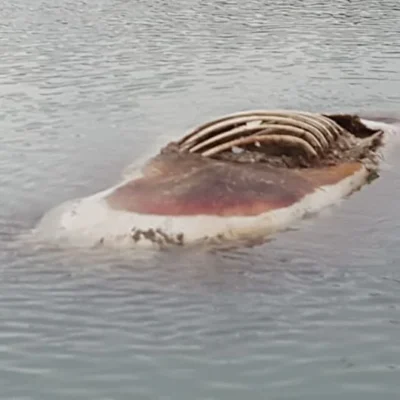
| Beluga Whales | Cook Inlet belugas are a genetically distinct, endangered population. About 300 remain. They feed on salmon in the inlet during summer. Visible from the bluffs as white shapes surfacing in the gray water |
| Hidden Gem | Most Kenai Peninsula visitors head south on the Sterling Highway toward Homer, Seward, or the Kenai River. Captain Cook SRA sits on the northern spur — the road less traveled. Same peninsula, same scenery, far fewer people |
Best Time to Visit
| Season | Best For |
|---|---|
| Summer (Jun–Aug) | ☀️ Longest days (19+ hours). Best volcano visibility. Salmon running. Belugas in the inlet. Wildflowers. The campground at its finest |
| Fall (Sep) | Silver salmon. Fall colors on the birch trees. Fewer visitors. Clear weather for volcano views. Northern lights beginning |
| Spring (May) | Season opening. Birds returning. Bears emerging. Snow melting. The inlet still cold and gray |
| Winter (Oct–Apr) | Campground closed. Short days. But the northern lights over Cook Inlet — with volcanoes silhouetted — are unforgettable for the hardy few |
Frequently Asked Questions
Is this near the Kenai River?
Same peninsula, different highway. The Kenai River is south on the Sterling Highway. Captain Cook SRA is north on the Kenai Spur Highway. They’re about 50 miles apart. The tradeoff: the Kenai River has world-class salmon fishing and heavy crowds. Captain Cook has solitude and volcanoes.
Can I walk on the mudflats?
No. Absolutely not. Cook Inlet mudflats are among the most dangerous coastal environments in Alaska. The glacial silt mud has trapped and killed people. The tides come in faster than you can run. Stay on solid ground above the tide line.
More parks nearby: Captain Cook State Recreation Area Stormy Lake at Captain Cook SRA is a short drive away, while Scout Lake State Recreation Site lies within about an hour’s drive.
Camping reservations: Book campsites and cabins for Alaska state parks online at alaskastateparks.reserveamerica.com.
🌋 Three Volcanoes. An Inlet With 30-Foot Tides. And the Campground No One Knows About.
The end of the road on the Kenai Peninsula. Active volcanoes across the water. Belugas in the inlet. Agates on the beach. And the kind of quiet that comes from being past where everyone else turned.

Park Location

Top Tours & Activities Near Kenai
 from $250
 from $300
 from $300