🌤 Weather at Culpeper Battlefields State Park by season
| Spring | Summer | Fall | Winter |
|---|---|---|---|
| 31–74 °F | 59–86 °F | 32–78 °F | 23–48 °F |
Each range runs from the coldest monthly average low to the warmest monthly average high in that season (1991-2020 climate normals), measured at Boston 4 SE, 6 mi away, elevation 590 ft. Conditions at the park can differ from the station, especially where elevation differs — check a forecast before you go.
Virginia’s Newest State Park — Walking the Largest Cavalry Battle in North America & Four Civil War Battlefields
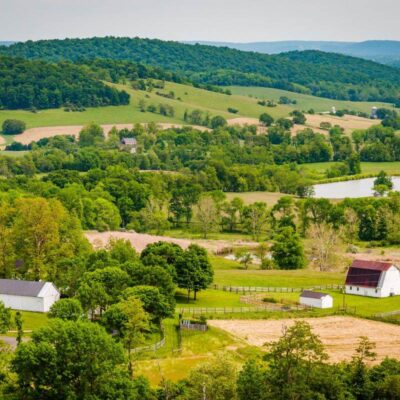
Culpeper Battlefields State Park — officially dedicated June 8, 2024 — is Virginia’s newest state park and one of the most significant Civil War battlefield preservation projects in the nation. The park protects land associated with four major battles fought in Culpeper County between 1862 and 1863: Brandy Station, Cedar Mountain, Kelly’s Ford, and Rappahannock Station. These engagements shaped the trajectory of the war in Virginia’s Piedmont and collectively tell the story of the transition from Confederate dominance to Union ascendancy in the Eastern Theater.
The Battle of Brandy Station (June 9, 1863) holds a unique distinction in military history — it was the largest cavalry battle ever fought on the North American continent, involving more than 20,000 mounted troops and marking the opening of the Gettysburg Campaign. The park is still actively expanding through planned land transfers expected to continue through 2027, with new interpretive trails and wayside exhibits being developed across the scattered battlefield sites.
Things to Do
Battlefield Trails & Interpretation
The park encompasses multiple disconnected battlefield sites, each with its own trail system and interpretive wayside exhibits:
Brandy Station Battlefield
- Fleetwood Hill Trail: 0.26-mile interpretive loop at the epicenter of the largest cavalry battle in North America — owned by DCR
- Buford’s Knoll Trail: 2.52-mile, seven-stop trail covering Beverly Ford Road action — managed by the American Battlefield Trust
- St. James Church Trail: ~0.75-mile loop with four wayside signs interpreting the 1863 fighting and 1863–1864 winter encampments
Cedar Mountain Battlefield
- Main Interpretive Loop: ~1.25-mile trail with 10 interpretive stops covering the August 9, 1862 battle — the opening salvo of the Second Manassas Campaign
- Extended Trail: ~1-mile additional trail featuring a witness tree and a monument to the 3rd Wisconsin Regiment
- Key moment: This was Stonewall Jackson’s final independent command before his legendary partnership with Robert E. Lee
Historic Context
The four battlefields collectively represent a critical 18-month period (August 1862 – November 1863) that saw Culpeper County become one of the most contested landscapes of the Civil War. The region served as a staging ground, winter quarters, and battlefield for both armies — its rolling Piedmont terrain was ideal for cavalry operations and the movement of large forces.
Trails
| Trail | Distance | Difficulty | Highlights |
|---|---|---|---|
| Fleetwood Hill (Brandy Station) | 0.26 mi loop | Easy | Epicenter of largest cavalry battle in North America |
| Buford’s Knoll (Brandy Station) | 2.52 mi | Easy–Moderate | Beverly Ford Road; 7 interpretive stops |
| St. James Church (Brandy Station) | ~0.75 mi loop | Easy | 1863 battle; winter encampment sites |
| Cedar Mountain Interpretive Loop | ~1.25 mi | Easy | 10 stops; Jackson’s final independent command |
| Cedar Mountain Extended | ~1 mi | Easy | Witness tree; 3rd Wisconsin Monument |
Best Time to Visit
| Season | Highlights | Considerations |
|---|---|---|
| Spring (Apr–May) | ⭐ Wildflowers on battlefields; comfortable walking weather; anniversary events | Some fields may be muddy; check trail status |
| Summer (Jun–Aug) | Brandy Station anniversary (June 9); full interpretive hours; long days for touring | Hot and humid; bring water; tick-heavy; limited shade |
| Fall (Sep–Nov) | ⭐ PEAK: Piedmont foliage; cool walking; Cedar Mountain anniversary (Aug/Sep) | Shorter days; some facilities may have reduced hours |
| Winter (Dec–Mar) | Bare-field views reveal terrain features invisible in summer; quiet, reflective | Limited facilities; park office may have reduced hours; dress warmly |
Visitor Tips
- Still developing: Culpeper Battlefields is Virginia’s newest state park (dedicated 2024) and is still actively expanding. Facilities are limited — no camping, no visitor center yet. Check the official DCR website for current status before your visit.
- Multiple sites: The park is not a single contiguous area — the battlefields are scattered across Culpeper County. You’ll need a car to drive between Brandy Station, Cedar Mountain, Kelly’s Ford, and Rappahannock Station. Plan a full day for all four sites.
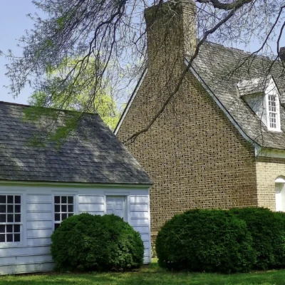
- Graffiti House: Don’t miss the Graffiti House in Brandy Station, a Civil War–era building that served as a hospital. The interior walls still bear original wartime graffiti from soldiers — an extraordinary primary source artifact.
- Metal detecting: Strictly prohibited on all park property. These are protected archaeological sites.
- Downtown Culpeper: The Culpeper Museum of History in the charming downtown provides excellent context before touring the battlefields. The town itself is worth exploring for dining and historic architecture.
- Dog-friendly: Leashed dogs are welcome on all trails.
Frequently Asked Questions
Wildlife & Nature
Culpeper Battlefields SP — preserves Civil War battlefield sites in Culpeper County, where major engagements took place between 1862-1864. The county saw more cavalry action than any other in the Civil War. The park’s meadows, hedgerows, and hardwood forest support red-tailed hawks, meadowlarks, and white-tailed deer.
Nearby Attractions
Culpeper — adjacent. Brandy Station Battlefield — nearby — site of the largest cavalry battle in North America (June 9, 1863). Cedar Mountain Battlefield — nearby.
What battles are preserved at Culpeper Battlefields State Park?
Culpeper Battlefields State Park protects land associated with four major Civil War engagements: the Battle of Brandy Station (June 9, 1863) — the largest cavalry battle in North American history; the Battle of Cedar Mountain (August 9, 1862) — Stonewall Jackson’s final independent command; the Battle of Kelly’s Ford (March 17, 1863); and the Battle of Rappahannock Station (November 7, 1863). Together, these battles represent a critical 18-month period that shifted momentum from Confederate dominance to Union ascendancy in Virginia’s Piedmont.
Can you camp at Culpeper Battlefields State Park?
No — Culpeper Battlefields is a day-use park with no camping facilities. The park was officially dedicated in June 2024 and is still actively developing. Check the Virginia DCR website for the latest information on facilities and hours. For camping near Culpeper, consider George Washington and Jefferson National Forests or private campgrounds in the area.
Last updated: April 2026
Keep exploring: The closest neighbors are Lake Anna State Park (within about an hour’s drive) and Shenandoah River State Park (within about an hour’s drive).

🐾 Dogs & Pets at Culpeper Battlefields State Park
- Pets allowed? statewide rule
- Pets are welcome throughout Virginia State Parks, including campgrounds and trails, as long as they are confined or leashed and supervised.
- Leash rule statewide rule
- 6 ft maximum leash (or confinement) required, with pet under supervision at all times
- Beaches & swim areas statewide rule
- State regulations prohibit pets on public swimming beaches and at designated swimming areas
- Cabins & lodging statewide rule
- Pet-friendly cabin stays available for a $20 per pet per night fee; yurts do not allow pets; pets prohibited in public facilities
- Pet fees statewide rule
- No charge for pets in campgrounds; $20 per pet per night in cabins
- Statewide exceptions statewide rule
- At False Cape, pets may not pass through Back Bay National Wildlife Refuge
Are dogs allowed at Culpeper Battlefields State Park?
Pets are welcome throughout Virginia State Parks, including campgrounds and trails, as long as they are confined or leashed and supervised. Individual parks can post stricter rules — check signage on arrival.
Rules verified July 2026 via dcr.virginia.gov. More: Virginia state parks guide · Dog rules in all 50 states compared
Park Location
Plan your gear for Culpeper Battlefields State Park
From our editorial guides, matched to this park’s activities:

Top Tours & Activities Near Fredericksburg
 from $30
 from $29
 from $29