Denali State Park
Where Alaska’s Greatest Mountain Towers Over 324,000 Acres of Pure Wilderness
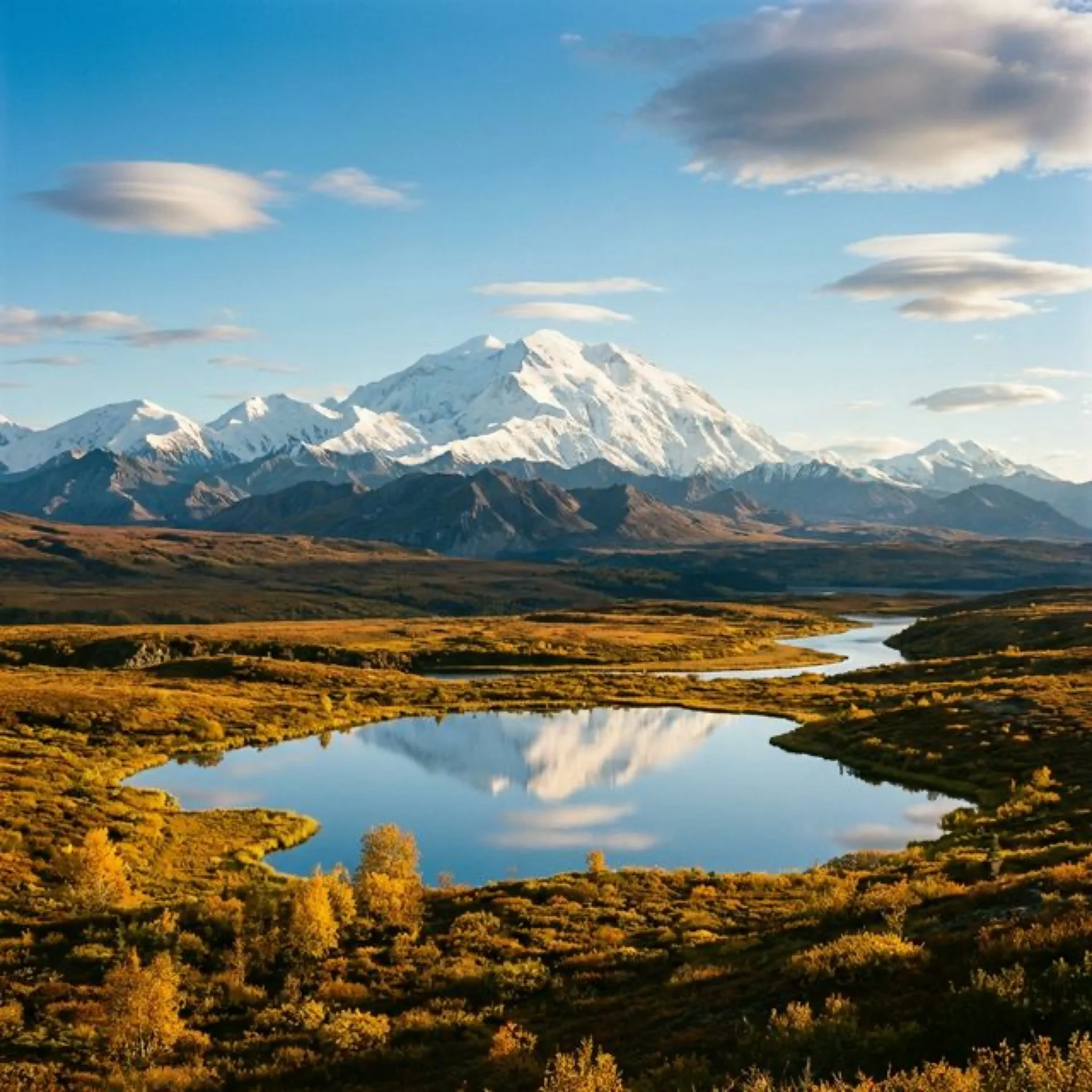
Denali State Park is a 324,240-acre wilderness that exists for one singular, soul-expanding purpose: to put you face-to-face with the highest mountain in North America. At 20,310 feet, Denali — “The High One” in the Koyukon Athabascan language — dominates the Alaska Range with such overwhelming physical presence that it creates its own weather systems, and from the alpine ridges of this state park, you can watch those storms build and break against the mountain’s flanks in real time. This is not a park you visit casually. This is a park that recalibrates your understanding of scale, of wilderness, of what “big” actually means when stripped of human reference points.
Situated 147 miles north of Anchorage along the George Parks Highway — the main road link between Alaska’s largest city and Fairbanks — Denali State Park occupies the south side of the Alaska Range and offers something its more famous federal neighbor, Denali National Park, cannot: unrestricted access, drive-up campgrounds, and some of the finest unobstructed views of the mountain from trails you can reach within minutes of parking your car. While the national park restricts private vehicles beyond Mile 15 of its single road, the state park sprawls openly along the highway, welcoming visitors to pull over, step out, and have their breath stolen by a mountain that fills the entire northern horizon.
🏔️ At a Glance
- Size: 324,240 acres (507 square miles) — one of the largest state parks in the US
- Elevation Range: 550 ft (Chulitna River) to 5,761 ft (Curry Ridge)
- Named For: Denali, “The High One” — the 20,310 ft mountain visible from the park
- Location: Matanuska-Susitna Borough, 147 miles north of Anchorage on Parks Highway
- Season: Year-round access, campgrounds open mid-May through mid-September
- Admission: Day-use parking $5; camping $15-35/night
The Kesugi Ridge: Alaska’s Most Spectacular Multi-Day Hike
The crown jewel of Denali State Park is the Kesugi Ridge Trail — a 27.4-mile traverse along an alpine ridgeline that maintains elevations between 3,500 and 5,000 feet, offering continuous, panoramic views of Denali and the entire Alaska Range that rank among the most dramatic hiking vistas anywhere on Earth. This is not casual day-hiking territory. This is multi-day expedition hiking through genuine Alaskan wilderness where grizzly bears outnumber humans, where weather can shift from sunshine to snow in twenty minutes, and where the scale of the landscape makes experienced hikers feel like beginners.
The ridge runs roughly north-south between two trailheads accessible from the Parks Highway: the Little Coal Creek Trailhead at Mile 163.8 (southern end) and the Byers Lake Trailhead at Mile 147 (northern end). Most backpackers hike south-to-north over 2-4 days, which means the hardest climbing comes first — a 3,500-foot ascent from Little Coal Creek to the ridgeline — and the final miles descend gently through boreal forest to Byers Lake. The logistics are straightforward but require planning: you’ll need a shuttle between trailheads (the distance by road is about 17 miles), bear-resistant food canisters (strongly recommended April 15 through October 15), and the mental fortitude to camp above treeline in a landscape where the nearest paved road feels like another planet.
What makes Kesugi Ridge extraordinary isn’t just the views — though on clear days, Denali fills roughly 40 degrees of your visual field, a physical impossibility that your brain struggles to process. It’s the ecosystem transition. You’ll pass through dense spruce and birch forest, emerge into subalpine tundra carpeted with dwarf willow and blueberry, cross alpine meadows blazing with wildflowers in July and August, traverse exposed ridgelines with 360-degree views, and descend through old-growth spruce forest so thick and mossy it feels primordial. Every mile presents a fundamentally different landscape, and every landscape includes Denali.
Day Hikes for Every Ability Level
You don’t need a multi-day expedition to experience the magic of Denali State Park. Several day hikes offer extraordinary views of the mountain with far less commitment, though all require awareness that this is genuine Alaskan wilderness — carry bear spray, make noise, and check conditions at the K’esugi Ken Campground ranger station before heading out.
| Trail | Distance | Difficulty | Highlights |
|---|---|---|---|
| Curry Ridge Trail | 5.2 mi RT | Moderate-Strenuous | Alpine tundra, panoramic Denali views, wildflowers |
| Byers Lake Loop | 4.8 mi loop | Easy-Moderate | Lakeshore walking, fishing, mountain reflections |
| Moose Flats Loop | 0.5 mi loop | Easy (wheelchair accessible) | Interpretive trail, Denali views, wetland ecology |
| Troublesome Creek | 15.2 mi RT | Strenuous | Remote creek valley, old-growth forest, solitude |
| Ermine Hill Trail | 3.6 mi RT | Moderate | Boreal forest, alpine views, berry picking |
The Curry Ridge Trail is the single best day hike in the park — possibly one of the best day hikes in Alaska. Starting from the K’esugi Ken Campground at Mile 135.4, it climbs steadily through spruce forest before breaking into alpine tundra, where the entire Alaska Range unfolds before you like a geological symphony. On clear days — which occur roughly 30% of the time between June and September — the view includes not just Denali but the satellite peaks of Mount Foraker (17,400 ft) and Mount Hunter (14,573 ft), a trinity of mountains that represents the highest concentration of vertical relief in North America.
For families and visitors with mobility challenges, the Moose Flats Loop Trail offers a wheelchair-accessible, half-mile interpretive walk near K’esugi Ken Campground with surprisingly excellent views of Denali on clear days. Interpretive signs explain the park’s ecology, geology, and Athabascan cultural connections, making it both educational and visually stunning.
Campgrounds: Six Ways to Sleep in the Shadow of the High One
Denali State Park offers a range of camping experiences from developed drive-up campgrounds to remote backcountry sites, all sharing one extraordinary feature: on clear evenings, you can watch the alpenglow turn Denali from white to gold to pink to purple from the comfort of your campsite. Most campsites operate on a first-come, first-served basis (exception: K’esugi Ken, which accepts reservations), and the season runs from mid-May through mid-September, though exact dates vary with snowmelt.
⛺ Campground Guide
- K’esugi Ken Campground (Mile 135.4) — Newest and most developed: 32 RV sites with electricity, 10 walk-in tent sites, 3 public-use cabins, ranger station, interpretive center. Reservations available.
- Byers Lake Campground (Mile 147) — Classic Alaskan wilderness camping: 73 wooded sites, picnic areas, boat launch, canoe/kayak rentals. Stunning lake setting with mountain backdrops.
- Byers Lake Lakeshore — 6 walk-in sites directly on the lakeshore for a more secluded experience.
- Denali View North (Mile 162.7) — 20 sites with drinking water, spectacular Denali and Alaska Range views. Popular with RVers.
- Denali Viewpoint South (Mile 135.2) — 9 sites with prime mountain views and picnic areas.
- Lower Troublesome Creek — Remote, rarely fills, accessed via Troublesome Creek Trailhead. True solitude.
The public-use cabins at K’esugi Ken deserve special mention. These heated cabins sleep up to six people, include bunks, a wood-burning stove, and a covered porch — and they book up months in advance during peak season. At roughly $75/night, they represent one of the best lodging values in Alaska, offering a warm, dry shelter in a landscape where the weather can turn hostile without warning. Reserve through the Alaska State Parks website as early as possible.
Wildlife: Living Among Giants
Denali State Park is not a zoo with trails. It is a functioning wilderness ecosystem where large predators and mega-herbivores go about their lives alongside — and occasionally across the paths of — human visitors. The wildlife here is not habituated to people; it is genuinely wild, and encounters feel less like observation and more like an audience with creatures who own the landscape and merely tolerate your presence.
Grizzly bears are the apex presence. An estimated 300-350 grizzlies use the greater Denali ecosystem, and the state park’s berry-rich alpine tundra provides critical late-summer forage. August and September hikers on Kesugi Ridge routinely spot grizzlies feeding on blueberries at distances ranging from comfortable (half mile) to intimate (200 yards). Carry bear spray, know how to use it, and make noise on the trail. Bear encounters in this park are not a matter of “if” but “when.”
The park also supports healthy populations of moose — look for them feeding in the willow thickets along the Chulitna River and around Byers Lake — caribou from the Nelchina herd occasionally spotted on the higher ridges, wolves whose tracks appear on muddy trails with eerie regularity, Dall sheep visible on the distant cliffs of the Alaska Range, and beavers whose engineering projects reshape the wetlands around Byers Lake with precision that would impress any civil engineer.
The Alaska Range: Understanding What You’re Seeing
When you stand on Curry Ridge and look north, you’re witnessing one of the most geologically dramatic views on Planet Earth. Denali and the Alaska Range represent the ongoing collision between the Pacific Plate and the North American Plate — a tectonic confrontation that has been pushing these mountains upward for approximately 60 million years. Denali itself is growing at roughly 1 millimeter per year, a rate that barely keeps pace with the erosional forces trying to tear it down.
What makes the view so extraordinary is the base-to-summit rise. While Everest is technically higher above sea level (29,032 ft), Denali’s base-to-summit vertical rise of approximately 18,000 feet — from the lowlands near Wonder Lake to the summit — is the greatest of any mountain on Earth. You are literally looking at more mountain, more vertical feet of rock and ice and snow, than anywhere else on the planet. The scale defeats comprehension. Your brain insists it must be closer than it is, smaller than it is, less real than it is. It is none of those things.
The mountain’s massive size creates its own weather — lenticular clouds that form over the summit, katabatic winds that pour down the glaciers, and the legendary “Denali wave cloud” that experienced mountaineers recognize as a sign of extreme high-altitude winds. From the state park’s viewpoints, you can watch these phenomena unfold in real time, a weather laboratory performing experiments at the scale of continents.
Byers Lake: Paddling in Mountain Reflections
Byers Lake is a 2-mile-long, glacier-carved gem nestled in the boreal forest at the northern end of the park. On calm mornings — and Alaska produces some spectacularly calm mornings — the lake’s surface becomes a perfect mirror reflecting Denali and the surrounding peaks so precisely that photographs appear reversible. Canoe and kayak rentals are available at the Byers Lake Campground during summer months, and paddling the lake’s perimeter (roughly 5 miles) offers perspectives on the mountain that you simply cannot access by trail.
The lake also supports excellent fishing for lake trout, rainbow trout, Arctic grayling, and burbot. The Chulitna River, which runs through the western portion of the park, adds silver and king salmon to the fishing menu during their seasonal runs (roughly July through September). Alaska’s catch regulations apply, and a state fishing license is required — pick one up in Talkeetna or Cantwell before arriving.
Seasonal Rhythms: When to Visit
Denali State Park operates on Alaska’s extreme seasonal clock, where summer days stretch past 20 hours of daylight and winter compresses the sun into a few pale hours. Understanding these rhythms is essential to planning a visit that matches your expectations.
📅 Seasonal Guide
- Late May – Early June: Campgrounds open, snow lingers on Kesugi Ridge, wildflowers begin. Long daylight (18-20 hrs). Bugs emerging.
- Late June – July: Peak wildflower season, best weather probability. Trails fully clear by early July. Mosquitoes at peak (bring head nets!).
- August: Berry season — tundra turns red and gold. Grizzly activity increases. Best month for photography. Bugs declining.
- September: Fall colors explode (dwarf birch goes crimson). First snows on ridges. Northern Lights begin. Campgrounds close mid-month.
- October – April: Winter. Cross-country skiing, snowshoeing, aurora viewing. Roads plowed but campgrounds closed. Extreme cold (-20°F to -40°F possible).
The critical question every visitor asks: will I see Denali? The mountain is visible approximately 30-40% of days during summer, with the best odds in late August and September, when the atmosphere clears after the summer moisture cycle. Overcast days don’t mean wasted days — the park’s forests, lakes, and wildlife remain extraordinary even without the mountain’s starring role. But if you’re planning a trip specifically for Denali views, budget at least 3-4 days to maximize your chances. Multiple visitors have spent a full week in the park before the clouds parted to reveal the mountain — and every one of them will tell you it was worth the wait.
Getting There and Getting Around
Denali State Park is accessed exclusively via the George Parks Highway (Alaska Route 3). There is no public transportation to the park, and no shuttle service within it — a personal vehicle is essential. From Anchorage, the drive takes approximately 2.5-3 hours (147 miles); from Fairbanks, approximately 4 hours (250 miles); and from the entrance to Denali National Park, approximately 1.5 hours (90 miles south).
The town of Talkeetna (Mile 98.7, then 14 miles east on the Talkeetna Spur Road) is the nearest full-service community, offering restaurants, lodging, grocery stores, and outfitter services. Talkeetna is also the base for Denali flightseeing operations — bush plane tours that circle the mountain at close range, offering views that redefine “once in a lifetime.” These flights typically cost $250-400 per person and operate weather-dependent from April through September.
| From | Distance | Drive Time | Route |
|---|---|---|---|
| Anchorage | 147 mi | 2.5-3 hrs | AK-1 N to AK-3 N (Parks Hwy) |
| Fairbanks | 250 mi | 4 hrs | AK-3 S (Parks Hwy) |
| Denali National Park | 90 mi | 1.5 hrs | AK-3 S (Parks Hwy) |
| Talkeetna | 50 mi | 1 hr | Talkeetna Spur Rd to AK-3 N |
Essential Planning Information
📋 Visitor Essentials
- Fees: Day-use parking $5; camping $15-35/night; cabins ~$75/night
- Reservations: K’esugi Ken only — book via Alaska State Parks website; all other campgrounds first-come, first-served
- Bear Safety: Bear spray REQUIRED for all hiking. Bear-resistant canisters strongly recommended for backcountry camping (Apr 15–Oct 15)
- Water: Carry water purification — giardia present in all surface water
- Cell Service: None in the park. Download maps and communicate plans before arriving
- Fuel: No gas stations in the park. Fill up in Cantwell (Mile 210) or Trapper Creek (Mile 115)
- Bugs: Mosquitoes and white-sox (biting gnats) intense June-July. Head nets and DEET essential
- Contact: Alaska State Parks Mat-Su Area Office: (907) 745-3975
Denali State Park doesn’t compete with its national park neighbor for attention — it offers something fundamentally different. Where Denali National Park provides structured, ranger-mediated wilderness experiences on limited-access buses, the state park opens 324,240 acres of genuine Alaskan wilderness to anyone willing to drive the highway, pull over, and step into a landscape where the tallest mountain on the continent fills the sky. No reservations needed. No shuttles required. No crowds blocking your view. Just you, the mountain, and more wild country than you could explore in a lifetime.


