Smith Rock State Park

Before there was Yosemite’s free climbing revolution, before Boulder’s sport climbing scene, there was Smith Rock. This volcanic wonderland in central Oregon is where American sport climbing was essentially invented in the 1980s, and it remains one of the most important climbing destinations on Earth. But you don’t need ropes to experience the magic here—the Misery Ridge Trail delivers some of Oregon’s most dramatic views to anyone willing to hike.
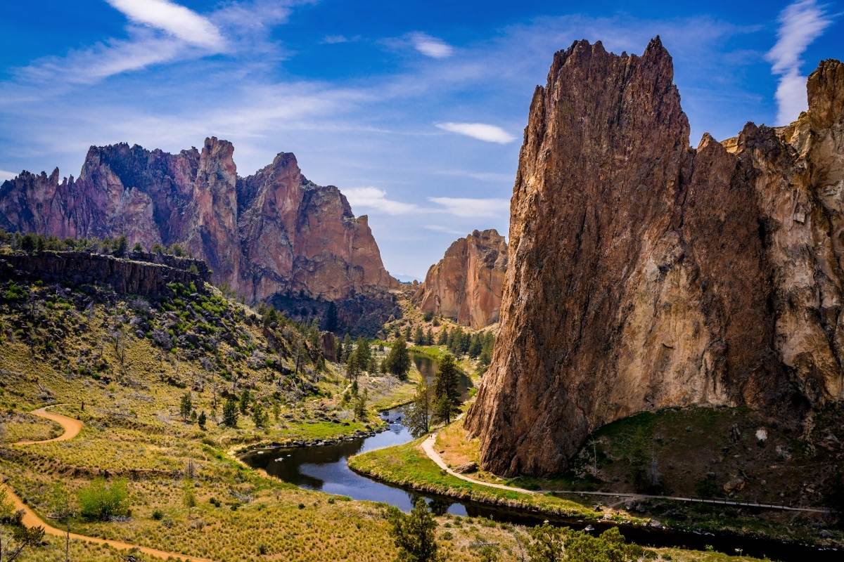
Rising 600 feet above the Crooked River’s turquoise ribbon, the ancient volcanic tuff formations of Smith Rock create a landscape that seems transported from another planet. The iconic Monkey Face—a 350-foot freestanding pillar that genuinely resembles a simian profile—hosts some of the world’s most famous climbing routes. But the park’s 652 acres offer far more than world-class rock: golden eagles and prairie falcons nest in the cliffs, river otters play in the Crooked River below, and the high desert blooms spectacularly in spring.
What makes Smith Rock truly special is its accessibility. Just 30 minutes from Bend, this is a place where casual hikers share trails with elite climbers, where families picnic while watching ascents of impossible-looking walls, and where anyone can feel the raw power of the Oregon high desert. Whether you come to climb, hike, photograph, or simply stand in awe, Smith Rock delivers an experience unlike anywhere else in the Pacific Northwest.
Park Fast Facts
Smith Rock State Park sits in Oregon’s high desert, where the Crooked River carved a dramatic canyon through ancient volcanic rock. The park was established between 1960-1975 and is thought to be named after either John Smith, a Linn County lawman, or Pvt. Volk Smith, a soldier who fell to his death here during a battle with the Northern Paiute in 1863—historians still debate which.
| 📍 Location | 9241 NE Crooked River Dr, Terrebonne, OR 97760 |
| 🗺️ Region | Central Oregon / Deschutes County |
| 📐 Total Area | 652 acres (264 hectares) |
| 🧗 Climbing Routes | 1,500+ routes, all grades |
| 🏔️ Canyon Depth | ~600 feet above river |
| 📅 Established | 1960-1975 |
| ⏰ Hours | Dawn to dusk (30 min before sunrise to 30 min after sunset) |
| 📞 Phone | (541) 548-7501 |
Day-Use Fees & Parking
All vehicles at Smith Rock require a valid Oregon Parks and Recreation Department (OPRD) permit. The fees increased in January 2025, with Oregon residents paying $10 and out-of-state visitors $12 for a daily permit. If you’re a regular visitor—or planning to explore Oregon’s excellent state park system—the annual pass provides excellent value.
| Permit Type | Oregon Resident | Non-Resident |
|---|---|---|
| 🚗 Daily Parking Permit | $10 | $12 |
| 📆 12-Month Annual Pass | $60 | $75 |
| 📆 24-Month Annual Pass | Available at park | Available at park |
💡 Tip: If you’re camping at any Oregon state park, your camping receipt serves as a parking permit!
Rock Climbing at Smith Rock
Smith Rock is where American sport climbing was born. In 1986, Alan Watts established “To Bolt or Not to Be”—widely considered America’s first 5.14 route—on these volcanic cliffs. The park transformed climbing culture, pioneering the use of bolted protection that made gymnastic movement on steep rock possible.
Today, the park offers over 1,500 routes across all grades, from beginner-friendly 5.6s to elite 5.15 test pieces. The rock is welded tuff—volcanic ash consolidated over millions of years—creating everything from finger-shredding crimps to bomber pocket holds. Routes range from single-pitch sport climbs to multi-pitch adventures ascending the canyon’s most dramatic formations.
| Climbing Area | Difficulty Range | Style | Highlights |
|---|---|---|---|
| 🐵 Monkey Face | 5.7 A0 to 5.14c | Multi-pitch | Iconic 350-ft spire; “Just Do It” 5.14c |
| 🌅 Morning Glory Wall | 5.9 to 5.13+ | Sport | Classic steep face; busy afternoons |
| 🪨 Dihedrals | 5.5 to 5.12 | Trad/Sport | Great for beginners; shaded AM |
| ☀️ Christian Brothers | 5.8 to 5.13 | Sport | Long routes; afternoon sun |
| 🔥 Red Wall | 5.10 to 5.14 | Sport | Steep, pumpy; advanced |
| 🌊 River Walls | 5.6 to 5.11 | Sport/Trad | Shaded; great moderate climbing |
⚠️ Seasonal Closures: Some climbing areas are closed Jan. 15 – Aug. 1 to protect golden eagle and falcon nesting. Check posted signs and smithrock.com for current closures.
The Monkey Face
The Monkey Face is Smith Rock’s most iconic formation—a 350-foot freestanding pillar that genuinely resembles a simian profile when viewed from the correct angle. Climbers from around the world pilgrimage here to test themselves on its overhanging walls. The formation hosts several legendary routes:
| Route | Grade | Description |
|---|---|---|
| 🎯 Pioneer Route | 5.7 A0 | First route to summit; bolt ladder to “Mouth Cave,” exit via “Panic Point” |
| 🧱 West Face | 5.9 A1 | Classic 4-pitch varied climbing to Bohn Street ledge |
| 🔥 Just Do It | 5.14c | World-famous test piece on east face |
| 🦴 The Backbone | 5.13 | Exposed arête; legendary Ron Kauk ascent |
| ⬇️ Descent | Rappel | 190-foot free-hanging rappel past east face |
Hiking Trails
You don’t need climbing skills to experience Smith Rock’s magic. The park’s trail system offers everything from easy riverside strolls to lung-burning ridge climbs, all with spectacular views of the volcanic formations and Crooked River canyon.
| Trail | Distance | Elevation | Difficulty | Highlights |
|---|---|---|---|---|
| 🏔️ Misery Ridge Loop | 3.7 mi | 1,000+ ft | Strenuous | Best views; Monkey Face overlook; connects to River Trail |
| 🌊 River Trail | 2.0 mi | Minimal | Easy | Flat riverside path; great for families |
| 🎿 Canyon Trail | 0.8 mi | 300 ft | Moderate | Descent to river; groups of 4 max |
| 🔭 Rim Rock Trail | 1.5 mi | Minimal | Easy | Viewpoints near parking; ADA accessible sections |
| 🏜️ Mesa Verde Trail | 1.2 mi | 200 ft | Moderate | Connects Misery Ridge to River Trail |
| 🗻 Summit Trail Loop | 5.5 mi | 1,200 ft | Strenuous | Longest loop; extends beyond Misery Ridge |
Misery Ridge Trail
Despite its ominous name, the Misery Ridge Trail is Smith Rock’s most popular and rewarding hike. The “misery” comes from the relentless switchbacks that gain over 1,000 feet in about a mile—but the views are worth every drop of sweat. From the summit, you’ll gaze down 700 feet to the Crooked River’s turquoise ribbon, across the volcanic spires where climbers appear as colorful specks on impossible walls, and out to the Cascade volcanoes on clear days.
The classic loop combines Misery Ridge with the River Trail for a 3.7-mile circuit. Descend via the Mesa Verde Trail for knee-friendly switchbacks, then follow the flat, shaded River Trail back to the trailhead. Budget 2-3 hours and bring plenty of water—the exposed ridgeline gets brutally hot in summer.
Wildlife & Raptors
Smith Rock’s cliffy habitat provides ideal nesting sites for some of Oregon’s most impressive raptors. Golden eagles and prairie falcons breed in the volcanic walls, launching from their eyries to hunt rabbits and ground squirrels across the high desert.
To protect these magnificent birds, some climbing areas are seasonally closed from approximately January 15 through August 1. The closures typically affect specific routes rather than entire walls—check posted signs at trailheads and on smithrock.com for current restrictions. Drones are prohibited during raptor nesting season (January 1 – July 31).
| Wildlife | When to See | Where |
|---|---|---|
| 🦅 Golden Eagles | Year-round (nesting Jan-Aug) | Cliff faces; soaring above canyon |
| 🐦 Prairie Falcons | Year-round (nesting Feb-July) | High walls; diving on prey |
| 🦎 Western Fence Lizards | Spring-Fall | Rock faces; doing “push-ups” on boulders |
| 🦫 Beavers | Dawn/Dusk | Crooked River |
| 🦦 River Otters | Year-round | Crooked River; playful mornings |
| 🦌 Mule Deer | Early morning | Trails and meadows |
Bivouac Camping
Smith Rock offers primitive walk-in bivouac camping for tent campers only. This is a first-come, first-served camping area—no reservations accepted—designed primarily for climbers who want to maximize their time on the rock. It’s a far cry from developed campgrounds, but for many visitors, waking up with dawn light on the canyon walls is worth the simplicity.
| Camping Detail | Information |
|---|---|
| 💵 Fee | $12 per person per night |
| 📅 Season | March 15 – November 15 (weather permitting) |
| 📋 Reservations | No – first-come, first-served only |
| ⛺ Tent Camping | Yes – walk-in bivouac sites |
| 🚐 RV Camping | No – not permitted |
| 🚗 Vehicle Sleeping | No – prohibited (county rule) |
| 🔥 Campfires | No – prohibited year-round |
| 🚿 Showers | Yes – overnight guests only |
| 💳 Permits | Purchase at fee station near bivouac entrance |
Alternative: USFS Skull Hollow Campground is located 9 miles NE on Lone Pine Road with 70 standard sites (no hookups, no water). Open seasonally.
Best Times to Visit
Central Oregon’s high desert climate means Smith Rock experiences extremes. Hot summers bring temperatures that can make rock climbing dangerous (the dark volcanic rock absorbs heat readily), while winters are cold but often climbable. The sweet spots are spring and fall, when moderate temperatures coincide with lower crowds.
| Season | Conditions | Best For | Considerations |
|---|---|---|---|
| 🌸 Spring (Mar-May) | 50-70°F; variable weather | Climbing, hiking, wildflowers | Prime; raptor closures in effect; weekends busy |
| ☀️ Summer (Jun-Aug) | 80-100°F; very hot | Early AM climbing only; river trail | Heat dangerous on rock; start before dawn |
| 🍂 Fall (Sep-Nov) | 50-75°F; crisp | All activities; photography | Best overall; fall colors; fewer crowds |
| ❄️ Winter (Dec-Feb) | 30-50°F; cold, possible snow | Cold-weather climbing; quiet trails | Raptor closures; bivouac closed; dress warm |
Getting There
Smith Rock is located about 30 minutes north of Bend in central Oregon. The park is just off Highway 97, making it easily accessible from Bend, Redmond, or Madras.
| From | Distance | Drive Time |
|---|---|---|
| 🏙️ Bend | 27 miles | 30-35 minutes |
| ✈️ Redmond (RDM) | 10 miles | 15 minutes |
| 🏔️ Madras | 25 miles | 25 minutes |
| 🌲 Portland | 140 miles | 3 hours |
Frequently Asked Questions
Do I need climbing experience to visit Smith Rock?
Not at all! The park’s hiking trails offer spectacular views without touching the rock. The Misery Ridge Loop is the signature hike, delivering panoramic views of the formations and opportunities to watch climbers on the walls. Many visitors come purely for hiking, photography, and wildlife watching.
Can I bring my dog to Smith Rock?
Yes, but dogs must be leashed at all times. Rangers actively enforce the leash law due to the park’s fragile ecosystem and wildlife. Bring water for your pet—trails are exposed and hot in summer.
What should I bring for climbing at Smith Rock?
For sport climbing: rope, quickdraws, harness, helmet, shoes, chalk, and belay device. The guidebook “The Smith Bible” by Allan Watts is essential for route information. Local guiding services are available for beginners—check Mountain Project or do an internet search for current operators.
Why are some climbing areas closed?
Seasonal closures (approximately Jan. 15 – Aug. 1) protect golden eagle and prairie falcon nesting sites. The closures typically affect specific routes rather than entire areas. Check posted signs and smithrock.com for current restrictions. Drones are also prohibited January 1 – July 31.
Can I sleep in my car at Smith Rock?
No—county rules prohibit sleeping in vehicles at Smith Rock State Park. The bivouac camping area is tent-only. If you need RV-friendly camping, try USFS Skull Hollow Campground (9 miles NE) or developed campgrounds near Bend.
How hard is the Misery Ridge Trail?
The trail is rated strenuous due to over 1,000 feet of elevation gain in about a mile via steep switchbacks. The 3.7-mile loop takes 2-3 hours. Bring plenty of water, wear sturdy shoes, and start early in summer—the ridge gets very hot. The views are absolutely worth the effort.
🧗 Experience the Birthplace of American Sport Climbing
Whether you’re here to send your project on the volcanic walls, hike to breathtaking overlooks, or simply marvel at one of Oregon’s most dramatic landscapes, Smith Rock delivers an experience you’ll never forget. Just 30 minutes from Bend, it’s one of the Pacific Northwest’s essential destinations.
📍 Address: 9241 NE Crooked River Dr, Terrebonne, OR 97760
🌐 Official Website: Oregon State Parks – Smith Rock
📞 Park Office: (541) 548-7501
🧗 Climbing Info: smithrock.com | Mountain Project


