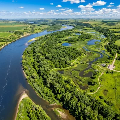
🏆🏆🏆🏆 Big Bend Country — Recreation area at the dramatic Big Bend of the Missouri River — where the river makes a 25-mile loop to cover just 1.5 miles of distance
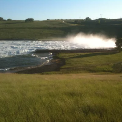
West Bend Recreation Area sits at the dramatic Big Bend of the Missouri River in Lyman County — one of the most remarkable geographic features on the entire Missouri. At the Big Bend, the river makes a 25-mile loop around a narrow neck of land just 1.5 miles wide. Lewis and Clark portaged across this neck in September 1804, saving a full day of paddling. Big Bend Dam (completed 1963) flooded much of the bend, creating Lake Sharpe. The Crow Creek Sioux Tribe’s reservation borders the area — the Crow Creek people suffered the devastating Whitestone Hill and Crow Creek internment in the 1860s, one of the darkest chapters in Dakota history.
Visitor Information
| Detail | Information |
|---|---|
| Location | Lyman County, SD |
| Entry Fee | SD Park Entrance License required |
| Geography | 25-mile loop for 1.5 miles! |
| Lewis & Clark | Portaged here 1804! |
About West Bend
West Bend Recreation Area in Lyman County provides recreation at the western side of the Missouri River’s Big Bend — the dramatic 25-mile loop that so impressed Lewis and Clark in 1804. The bend nearly creates an island — the river comes within 1.5 miles of itself while traveling 25 miles around the loop. It’s one of the most remarkable geographic features on the Missouri.
Things to Do
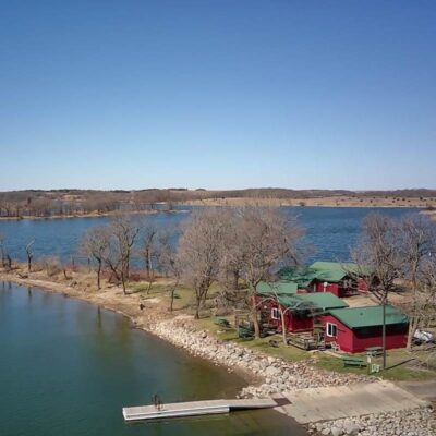
Fishing for walleye and bass on Lake Sharpe, camping (90+ sites), boating, exploring the Big Bend geography, and tracing the Lewis and Clark expedition route.
Insider Tips
Big Bend: West Bend sits near the Big Bend of the Missouri — where the river makes a dramatic 25-mile loop that covers only 1.5 miles as the crow flies. Pro tip: Lewis and Clark noted the Big Bend in 1804 — they walked across the narrow neck while the boats went around the loop. Native American history: The Big Bend area was home to the Arikara — agricultural people who lived in earth lodge villages along the Missouri.
Best Time to Visit
Summer: Lake recreation. Fall: Dramatic sky photography. Spring: Fishing and birding. Winter: Austere prairie beauty.
Frequently Asked Questions
Who were the Arikara?
The Arikara were agricultural people who lived in permanent earth lodge villages along the Missouri River — growing corn, beans, squash, and sunflowers. They were related to the Pawnee. Smallpox epidemics (1780s, 1830s) devastated their population — reducing them from 20,000+ to fewer than 2,000. The Arikara eventually merged with the Mandan and Hidatsa at Fort Berthold Reservation in North Dakota.
Keep exploring: The closest neighbors are Sandy Shore Recreation Area (a short drive away) and North Wheeler Recreation Area (a short drive away).
🌊 Visit West Bend Recreation Area
Big Bend — 25-mile river loop, Lewis & Clark portage of 1804!
Wildlife & Nature
West Bend RA — on Lake Sharpe. The area’s Missouri River bluffs, prairie, and lake support bald eagles, white-tailed deer, and ring-necked pheasants.
Nearby Attractions
Pierre — nearby. Missouri River — at the park. Lower Brule Indian Reservation — nearby.