Angel Island State Park
Angel Island State Park: The Golden Gate’s Hidden Island Paradise
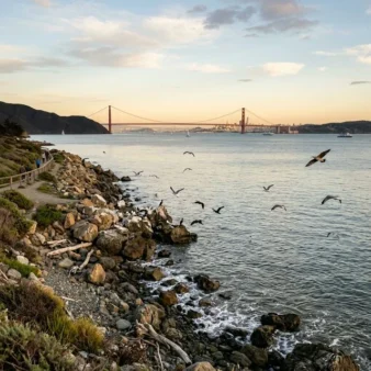
Rising dramatically from the center of San Francisco Bay, Angel Island State Park is California’s most unique state park — a 740-acre island accessible only by ferry, offering 360-degree panoramic views of the Golden Gate Bridge, San Francisco skyline, Alcatraz, and the rolling hills of Marin County. But beneath its stunning beauty lies a profound and moving history that earned Angel Island the title “Ellis Island of the West.”
From sacred Miwok fishing grounds to a Civil War military post, from a Cold War Nike missile site to one of America’s most significant immigration stations, Angel Island packs more history per acre than almost any park in the nation. Today, visitors come to hike to the 788-foot summit of Mount Livermore, explore the restored Immigration Station barracks, and experience a taste of island wilderness just minutes from one of the world’s great cities.
Park Facts at a Glance
| Information | Details |
|---|---|
| 📍 Location | San Francisco Bay, Marin County, California |
| 📐 Size | 740 acres (1.2 sq mi) |
| 🏛️ Park Since | 1963 (Army transferred to CA State Parks) |
| 🕐 Hours | 8:00 AM to sunset, 365 days/year |
| 💰 Entry Fee | Included with ferry ticket |
| ⛴️ Ferry | From SF ($15.50 adult) or Tiburon ($15 adult) |
| 🏕️ Camping | 10 primitive campsites (hike-in only) |
| 📞 Phone | (415) 435-5390 |
| 🌐 Website | parks.ca.gov |
| ⭐ Highlights | Immigration Station, Mt. Livermore, Golden Gate views |
The Immigration Station: America’s Forgotten Gateway
From 1910 to 1940, the Angel Island Immigration Station processed approximately 300,000 immigrants from over 80 countries — primarily from China, Japan, Korea, India, and the Philippines. Unlike New York’s Ellis Island, which welcomed immigrants, Angel Island was designed to detain, interrogate, and often exclude Asian immigrants under the racist Chinese Exclusion Act of 1882.
Immigrants were held in cramped barracks for weeks, months, or sometimes years while they underwent interrogation. Many Chinese detainees carved poetry into the wooden walls of the barracks, expressing their anguish, hope, and frustration. These wall poems — over 200 have been documented — represent one of the most powerful forms of immigrant testimony in American history.
Today, the restored detention barracks function as a museum where visitors can see the original wall carvings and learn about this pivotal chapter in American immigration history. The nearby Angel Island Immigration Museum (AIIM) offers free entry with additional exhibits and artifacts.
Trails and Hiking
| Trail | Distance | Difficulty | Highlight |
|---|---|---|---|
| Perimeter Road | 5.0 mi loop | Easy-Moderate | Paved, panoramic bay views, bikes allowed |
| Mt. Livermore (North Ridge) | 2.0 mi one-way | Moderate | 360° summit views, 788 ft elevation |
| Sunset Trail | 2.5 mi | Moderate | Golden Gate Bridge sunset views |
| North Ridge–Sunset Loop | 5.2 mi | Moderate | Full island experience, summit + coast |
| Immigration Station Trail | 0.5 mi | Easy | Connects ferry to Immigration Station |
| Camp Reynolds Trail | 1.5 mi | Easy | Civil War-era fort and Officer’s Row |
| Fort McDowell Trail | 1.0 mi | Easy | WWI & WWII military installations |
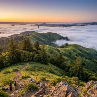
Angel Island features 12 miles of trails and roads offering exploration for every fitness level. The Perimeter Road is the signature experience — a 5-mile paved loop circling the island with continuously changing views of the bay, bridges, and skyline. It’s one of the most scenic bike rides in the entire Bay Area.
For hikers, the Mount Livermore summit trail rewards with arguably the finest 360-degree panorama in the entire San Francisco Bay Area. On a clear day, you can see the Farallon Islands 30 miles out in the Pacific, the snow-capped Sierra Nevada to the east, and the entire sweep of the Bay from Richmond to San Jose.
Military History: Layers of Defense
Angel Island’s strategic position in San Francisco Bay made it a military asset for over a century:
- Camp Reynolds (1863): Civil War-era post on the island’s west side, with original officer’s quarters and parade ground still intact
- Fort McDowell (1900): Major embarkation/debarkation point during both World Wars — over 300,000 troops passed through
- Nike Missile Site (1954-1962): Cold War radar station and missile launch facility atop the island
- Quarantine Station: Public health facility where ships entering the bay were inspected for infectious diseases
Walking the island today, you encounter these layers of history at every turn — crumbling gun batteries, restored Victorian officers’ quarters, abandoned missile bunkers, and interpretive panels telling the stories of the soldiers, immigrants, and indigenous peoples who called this island home.
Camping on the Island
| Campsite | Capacity | Features | Notes |
|---|---|---|---|
| Ridge Sites (1-5) | 8 people each | Bay views, wind-protected | Moderate hike from ferry |
| East Bay Sites (6-9) | 8 people each | Sunrise views, sheltered | Near Perimeter Road |
| Kayak Camp (Site 10) | 8 people | Beachfront | Kayak/boat access preferred |
Camping on Angel Island is one of the Bay Area’s most exclusive wilderness experiences — just 10 primitive campsites exist on the entire island. You must hike everything in, including water, as there are no services at the campsites. The reward? Falling asleep to the sound of foghorns, watching city lights twinkle across the water, and waking to a sunrise over the East Bay hills.
Getting to Angel Island
| Ferry Route | Duration | Adult Fare | Schedule |
|---|---|---|---|
| SF Ferry Terminal → Angel Island | ~30 min | $15.50 (paper) / $9.75 (Clipper) | 4 departures daily, year-round |
| Tiburon → Angel Island | ~10 min | $15 round-trip | Multiple daily, seasonal schedule |
| Private Boat → Ayala Cove | Varies | $15 dock fee / $30 mooring | Year-round, first-come |
From San Francisco: The Golden Gate Ferry departs from the San Francisco Ferry Terminal (Embarcadero). Service runs 7 days a week year-round, though winter schedules are reduced. Purchase round-trip tickets in advance — tickets are not available on Angel Island.
From Tiburon: The Angel Island-Tiburon Ferry offers the shortest crossing (~10 minutes) from downtown Tiburon in Marin County. This route runs on a seasonal schedule with more frequent service in summer.
Seasonal Guide
| Season | Highlights | What to Pack |
|---|---|---|
| 🌸 Spring (Mar-May) | Wildflowers, whale watching from summit, mild temps | Layers, windbreaker, binoculars |
| ☀️ Summer (Jun-Aug) | Peak season, warmest days, extended ferry service, bike rentals | Sunscreen, hat, water, picnic lunch |
| 🍂 Fall (Sep-Nov) | Warmest weather (Indian summer), fewer crowds, golden light | Light layers, camera for sunset |
| ❄️ Winter (Dec-Feb) | Fewest visitors, storm watching, whale migration, reduced ferries | Rain gear, warm layers, thermos |
Wildlife and Nature
Despite its small size and proximity to a major city, Angel Island supports a surprisingly rich ecosystem:
- Marine Life: Harbor seals, sea lions, harbor porpoises, gray whales (winter migration)
- Birds: Over 150 species documented, including great blue herons, red-tailed hawks, brown pelicans, and Anna’s hummingbirds
- Land Animals: Black-tailed deer (abundant), raccoons, fox squirrels
- Plants: Coastal scrub, oak woodland, non-native eucalyptus groves, seasonal wildflower displays
The island’s waters are part of the Gulf of the Farallones National Marine Sanctuary, and gray whales can sometimes be spotted from Mount Livermore’s summit during their winter migration (December-April).
Budget Planner
| Expense | Cost | Notes |
|---|---|---|
| Ferry (SF, Clipper card) | $9.75 RT | Best value — get a Clipper card |
| Ferry (SF, paper ticket) | $15.50 RT | Youth/Senior/Disabled: $8.00 |
| Ferry (Tiburon) | $15.00 RT | Bike surcharge: $1.00 |
| Immigration Station | $5.00 | Youth $3, Under 5 Free |
| AIIM Museum | FREE | No reservation needed |
| Bike Rental | $15-$40 | Seasonal, at Ayala Cove |
| Camping | $30/night | Reserve 6 months ahead |
| Boat Dock Fee | $15 | Day use at Ayala Cove |
Safety and Tips
- Water: Bring your own! Water is available only at Ayala Cove — carry enough for your entire hike
- Wind & Fog: Bay conditions change rapidly. Even on warm San Francisco days, the island can be windy and 10-15°F cooler
- Sun: Limited shade on summit trails and Perimeter Road — wear sunscreen and a hat
- Ferry schedule: Always verify the last departure time before exploring. Missing the ferry means an unplanned overnight
- Cell service: Available on most of the island, but spotty in some interior areas
- No stores: The small Cove Café at Ayala Cove offers limited food seasonally — pack a lunch
- Bikes: Allowed on Perimeter Road only — foot trails and Mount Livermore are closed to cyclists
Frequently Asked Questions
How do I get to Angel Island State Park?
Angel Island is accessible only by water. The most popular option is the Golden Gate Ferry from the San Francisco Ferry Terminal (~30 minutes, $9.75-$15.50 round trip). You can also take the Angel Island-Tiburon Ferry from Tiburon (~10 minutes, $15 round trip). Private boats can dock at Ayala Cove for $15. No cars are allowed on the island.
Can you camp on Angel Island?
Yes! Angel Island has 10 primitive hike-in campsites available year-round at $30/night. You must pack in all supplies including water. Reservations through ReserveCalifornia.com open 6 months in advance and sell out quickly. Camping here offers a rare urban-wilderness experience with city skyline views.
What is the Angel Island Immigration Station?
The Angel Island Immigration Station operated from 1910 to 1940 as a major West Coast immigration processing center, often called the “Ellis Island of the West.” It processed approximately 300,000 immigrants, primarily from Asian countries. The restored detention barracks preserve poetry carved into the walls by Chinese immigrants during detention. Admission is $5 for adults, $3 for youth.
How long do you need to visit Angel Island?
Plan for at least 4-5 hours for a satisfying visit. A quick trip can cover the Immigration Station and a partial Perimeter Road walk in 3 hours. To hike Mount Livermore, bike the full Perimeter Road, and explore military sites, plan a full day (6-7 hours). Check ferry departure times to ensure you don’t miss the last boat.
Can you bring bikes to Angel Island?
Yes, you can bring your own bike on the ferry (small surcharge from Tiburon, free from SF). Bikes are also available for seasonal rental at Ayala Cove ($15-$40). Cycling is only permitted on the Perimeter Road — all foot trails and Mount Livermore are closed to bikes.
Is Angel Island worth visiting in winter?
Absolutely. Winter offers the fewest crowds, dramatic storm skies, and the possibility of spotting gray whales on their migration from the summit of Mount Livermore. Ferry service runs year-round (reduced schedule). Dress warmly and check the weather, as winter storms can be raw and windy on the exposed island.
Is there food available on Angel Island?
Limited food is available at the Cove Café near the ferry landing at Ayala Cove, but it operates seasonally with limited hours. It’s strongly recommended to pack your own lunch, snacks, and plenty of water. There are no other stores or restaurants on the island.
Nearby Attractions
- Alcatraz Island — 1.5 miles south, former federal penitentiary, separate NPS ferry
- Golden Gate Bridge — Walk or bike across, stunning views of Angel Island
- Tiburon Waterfront — Charming town with restaurants and bay views
- Muir Woods National Monument — Old-growth redwoods, 20 min from Tiburon
- Point Reyes National Seashore — 40 min from Tiburon, elephant seals and lighthouse