
⛰️ Vermont’s Most Iconic Mountain — The Highest Undeveloped Peak in the State With True Arctic-Alpine Tundra — Camel’s Hump State Park, 20,625 acres around the 4,083-foot summit of Camel’s Hump, Vermont’s third highest peak, only undeveloped summit above 4,000 feet, rare arctic-alpine tundra, Long Trail, panoramic 360° views, no summit road or building, challenging hikes from multiple trailheads — Washington/Chittenden County, VT
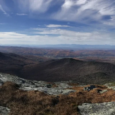
Every other major Vermont mountain has something on top — a road, a ski lift, a tower, a building. Camel’s Hump has nothing. At 4,083 feet, it’s the state’s third highest peak and the only one above 4,000 feet with an undeveloped summit. No road to the top. No antenna. No lodge. Just rock, wind, and a view that stretches from the Adirondacks to the White Mountains.
And something rarer: arctic-alpine tundra. Above treeline, the mountain supports fragile plant communities that have survived here since the last Ice Age — species that belong in Labrador or the Arctic Circle, stranded on this peak when the glaciers retreated 12,000 years ago.
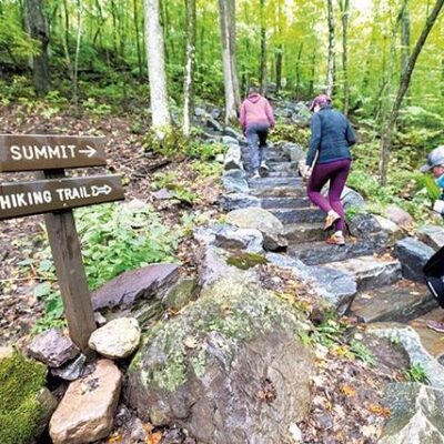
The Hikes
| Trail | Details |
|---|---|
| Burrows Trail | Most popular route — 2.4 miles, ~2,200 ft elevation gain from the Huntington side (west). Moderate to strenuous. Through hardwood forest, then spruce-fir, then above treeline. The fastest route to the summit |
| Monroe Trail | 3.3 miles from the Duxbury side (east). ~2,600 ft elevation gain. Slightly longer but less crowded. Passes through beautiful birch glades and mossy spruce forest. Meets the Long Trail near the summit |
| Long Trail | Vermont’s famous 273-mile end-to-end trail crosses the summit. You can summit Camel’s Hump as part of a multi-day Long Trail section hike or as a day hike from either direction. The trail follows the ridgeline above treeline |
| Forest City Trail | Alternative eastern approach — longer, quieter, through deeper forest. Connects to the Long Trail south of the summit. Less traffic, more wilderness feel |
The Alpine Zone
| Feature | Details |
|---|---|
| Arctic-Alpine Tundra | The summit supports 10+ acres of true alpine tundra — the same plant communities found above treeline in the Arctic. Diapensia, Bigelow’s sedge, alpine bilberry, and mountain sandwort cling to thin soil between exposed rock |
| Ice Age Relics | These plants colonized the mountain during the last glaciation. When the ice retreated, they survived only on the highest, coldest peaks. Camel’s Hump and Mt. Mansfield are the only Vermont mountains with significant alpine zones |
| Fragility | The alpine plants grow only millimeters per year. A single footstep can destroy decades of growth. Stay on marked trails and exposed rock above treeline — never step on the vegetation. Summit stewards are present during peak season to educate hikers |
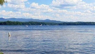
| The Name | Samuel de Champlain called it “le lion couchant” (the crouching lion) in 1609. By the 1800s, it was “Camel’s Rump” — later softened to “Camel’s Hump.” The distinctive profile is visible from Burlington, 25 miles away |
Best Time to Visit
| Season | Best For |
|---|---|
| Fall (Sep–Oct) | 🍂 Vermont foliage from above — the summit view of fall color is legendary. Cool, clear air. The best visibility of the year. Adirondacks and White Mountains visible simultaneously |
| Summer (Jun–Aug) | ☀️ Alpine plants blooming. Summit stewards on duty. Longest days. The most comfortable hiking weather. Thunderstorms possible — start early |
| Spring (May–Jun) | Mud season on the trails — many are closed to protect them from erosion. Check trail status. Snow lingers on the summit into May. The alpine zone is extremely fragile when wet |
| Winter (Dec–Mar) | Winter mountaineering — crampons, ice axe, and winter gear required above treeline. Sub-zero summit temps. High winds. Beautiful but serious. For experienced winter hikers only |
Frequently Asked Questions
How hard is the hike?
Moderate to strenuous — expect 4–7 hours round trip depending on your route and fitness. The Burrows Trail is the shortest (4.8 miles RT) but gains 2,200 feet. The last section above treeline is exposed to weather. Bring layers, rain gear, and extra water.
Can I bring my dog?
Dogs are allowed but must be leashed above treeline to protect the fragile alpine vegetation. Below treeline, voice control is acceptable on most trails. The rocky terrain above treeline can be hard on dog paws.
Keep exploring: The closest neighbors are Camels Hump State Park (a short drive away) and Little River State Park (a short drive away).
⛰️ No Road. No Building. No Tower. Just the Mountain.
Vermont’s only undeveloped summit above 4,000 feet. Arctic plants that have survived since the Ice Age. A 360° view from the Adirondacks to the White Mountains. And a profile so distinctive that Champlain named it from the lake in 1609.
Wildlife & Nature
Camel’s Hump SP — protects Camel’s Hump (4,083 ft) — Vermont’s third-highest peak and the highest undeveloped summit in the state. The summit’s alpine tundra is one of only three places in Vermont with true arctic-alpine vegetation — Ice Age relict plants that survive above treeline. Bicknell’s thrush nests near the summit. Black bears and moose roam the lower slopes.
Nearby Attractions
Huntington — western approach. Waterbury — 10 miles east. Ben & Jerry’s Factory — 10 miles east. Stowe — 20 miles northeast.
Park Location
Top Tours & Activities Near Stowe
 from $359
 from $359
 from $20