Franklin Mountains State Park
The Largest Urban Wilderness Park in America — 27,000 Acres of Chihuahuan Desert Rising Above El Paso
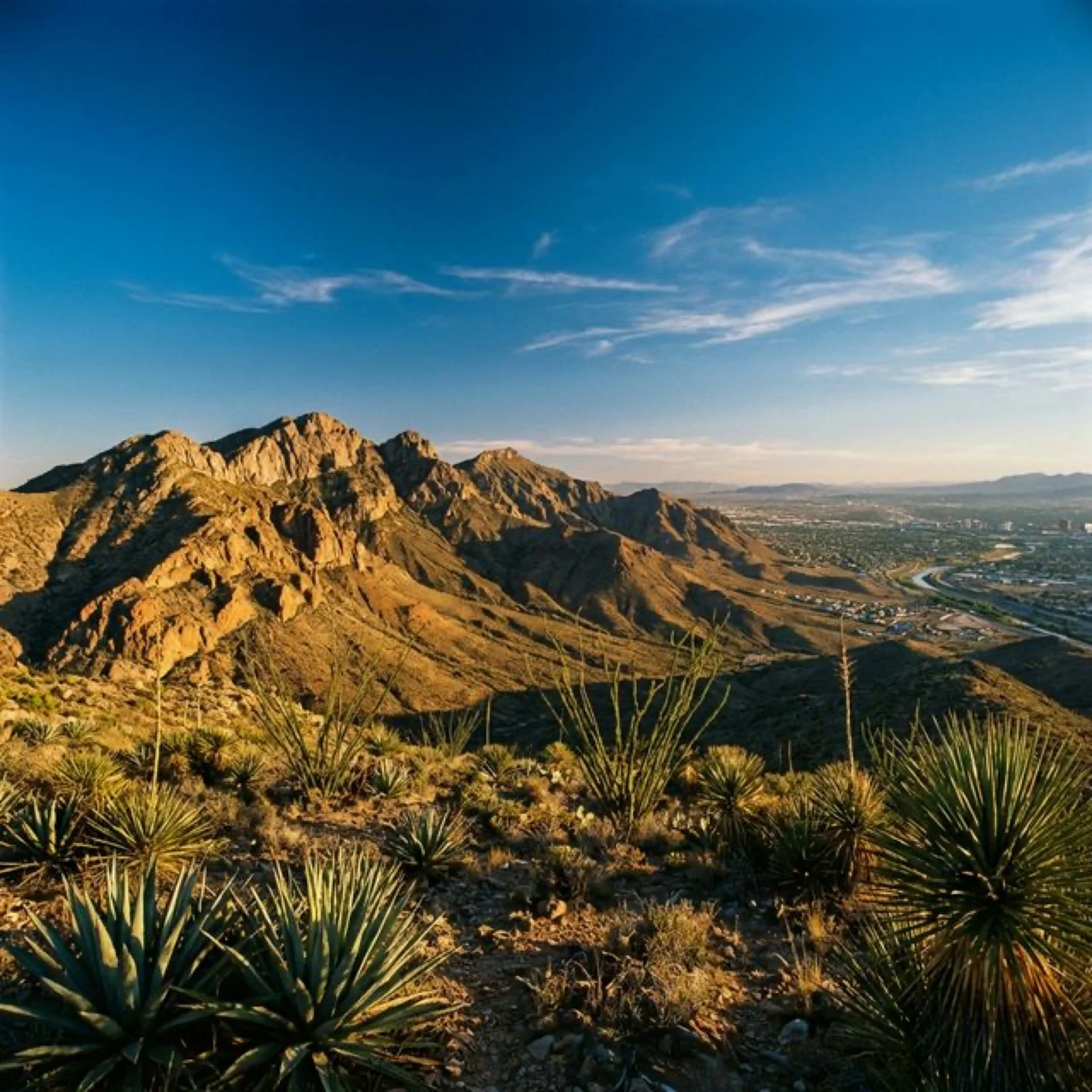
Franklin Mountains State Park is a geological anomaly and an urban planning miracle: nearly 27,000 acres of undeveloped Chihuahuan Desert mountain terrain sitting entirely within the city limits of El Paso, Texas. Nowhere else in the United States does a city of 700,000 people wrap around a state park this large, this wild, and this vertically dramatic. The Franklin Mountains rise 3,000 feet above the surrounding desert floor, their peaks reaching 7,192 feet at North Franklin Peak, and from their ridgelines you can see into three states and two countries — Texas, New Mexico, and Chihuahua, Mexico — with the Rio Grande cutting its ancient path through the landscape below.
This isn’t a manicured city park with paved paths and drinking fountains every quarter mile. This is a legitimate wilderness area where mountain lions hunt mule deer, where golden eagles spiral in thermals above exposed ridgelines, and where hikers have been rescued by helicopter after underestimating the desert’s capacity to punish the unprepared. The park exists because of a remarkable conservation effort in the 1970s-80s that prevented the entire mountain range from being subdivided into residential lots — a decision that preserved a 24-mile-long spine of desert mountains as permanent open space bisecting one of America’s fastest-growing border cities.
🏜️ At a Glance
- Size: 26,689 acres — largest urban state park in the nation
- Elevation Range: 4,100 ft (desert floor) to 7,192 ft (North Franklin Peak)
- Trail Network: 100+ miles of hiking, mountain biking, and equestrian trails
- Location: Entirely within El Paso city limits, far west Texas
- Admission: $5/adult, children 12 and under free
- Hours: 8 AM–5 PM (extended summer hours 6:30 AM–5 PM Fri-Sun)
Trail System: 100+ Miles Through an Ancient Desert Range
The park’s trail network is staggering in scope: over 100 miles of designated trails ranging from wheelchair-accessible nature walks to full-day ridge traverses that demand scrambling skills, route-finding ability, and a gallon of water per person. The terrain is uniformly rocky — this is the Chihuahuan Desert, where exposed limestone, rhyolite, and sandstone form the trail surface — and the elevation gains are real. What the Franklin Mountains lack in altitude compared to the Rockies, they compensate for in relentless steepness and total absence of shade.
Top Trails
| Trail | Distance | Difficulty | Highlights |
|---|---|---|---|
| Ron Coleman Trail | 5.2 mi one-way | Strenuous | Technical scrambles, ridgeline vistas, Mammoth Rock |
| North Franklin Peak | 8 mi RT | Strenuous | Highest point in El Paso (7,192 ft), 360° panoramas |
| Aztec Caves Trail | 1.6 mi RT | Moderate | Shallow rock shelters with ancient use evidence |
| West Cottonwood Springs | 3 mi RT | Moderate | Desert oasis, cottonwood shade, scenic vistas |
| Nature Walk Loop | 0.75 mi | Easy | Interpretive trail, desert plant identification |
| Lower/Upper Sunset Loop | 5 mi loop | Moderate | Ridgeline views, stunning sunset perspectives |
| Tin Mines Trail | 6 mi RT | Moderate-Strenuous | Historic mine shafts, smelter ruins, desert history |
The Ron Coleman Trail is the park’s signature challenge — a technical, strenuous route that climbs from McKelligon Canyon through exposed ridgelines featuring genuine hand-over-hand scrambling sections. The trail rewards with panoramic views that stretch from the Organ Mountains in New Mexico to the Sierra de Juárez in Mexico, with the Rio Grande valley floor 3,000 feet below. This is not a beginner trail. The footing is loose, the exposure is real, and the desert sun above 6,000 feet is unforgiving. Start early, carry more water than you think you need, and check in with yourself honestly at every decision point.
The North Franklin Peak Trail takes you to the literal high point of El Paso County at 7,192 feet. The 8-mile round trip gains approximately 3,000 feet of elevation through the Tom Mays Unit, and on clear days the summit views encompass approximately 7,000 square miles of desert landscape spanning three states and two countries. Budget 5-7 hours for the full hike and start before sunrise during summer months.
For a more accessible but still rewarding experience, the Aztec Caves Trail is a 1.6-mile round trip that climbs to a series of shallow rock shelters where archaeological evidence suggests human use spanning thousands of years. The caves themselves are shallow overhangs rather than deep caverns, but the views from the cave mouths over the desert valley are spectacular, and there’s a tangible sense of deep time — humans have been climbing to these exact spots to survey the landscape below for millennia.
Rock Climbing: El Paso’s Vertical Playground
The Franklin Mountains offer some of the best rock climbing in west Texas, with routes ranging from beginner-friendly bouldering problems to multi-pitch traditional climbs on exposed faces of rhyolite and limestone. The two primary climbing areas are McKelligon Canyon, which offers sport and trad routes on vertically fractured rock faces, and Sneed’s Cory in the Tom Mays Unit, which features longer multi-pitch routes with committing approaches.
The climbing season inverts the hiking season: the best conditions occur from November through February, when temperatures moderate to the 50s-60s and the sun isn’t actively trying to cook you against the rock. Late spring and early fall serve as shoulder seasons. Summer climbing is inadvisable — rock surface temperatures can exceed 140°F, making sustained handholds literally painful. All climbers must bring their own equipment; there are no outfitters or rental services within the park.
Mountain Biking: 125 Miles of Multi-Use Desert Singletrack
El Paso has quietly become one of the premier mountain biking destinations in the American Southwest, and Franklin Mountains State Park is the epicenter. The park offers 125 miles of multi-use trails that wind through rocky desert terrain, technical descents, and flowy singletrack that has attracted regional and national cycling events. The trail surfaces are predominantly rocky — this is not smooth dirt riding — and the exposure and elevation changes demand fitness, technical skill, and serious hydration planning.
Popular circuits include the Cardiac Road/Maze Loop (3 miles, moderate) for intermediate riders, the Palisades Canyon Loop for technical singletrack enthusiasts, and the Franklin Mountains Loop for riders seeking an all-day desert odyssey. The biking community has developed unofficial trail ratings and condition reports — check local forums and bike shops before planning aggressive rides, as flash flood damage occasionally reroutes established lines.
Wildlife of the Chihuahuan Desert
The Franklin Mountains support a surprising diversity of wildlife for an urban-adjacent park, including several species that most visitors associate with far more remote environments. The park’s position as an ecological island — surrounded by urban development on all sides — creates a compressed, high-stakes ecosystem where predator-prey dynamics play out in a confined geographic area.
Mountain lions are the park’s apex predator, and while sightings are genuinely rare, they are not mythology. The park maintains a resident population that feeds primarily on mule deer and desert bighorn sheep. Trail cameras have documented lions within yards of popular trails during non-peak hours, a sobering reminder that you’re sharing this landscape with an apex predator. Hike with at least one companion, make noise on blind corners, and never approach wildlife.
Other notable species include golden eagles (up to six breeding pairs nest in the range), mule deer frequently spotted near water sources at dawn and dusk, desert bighorn sheep occasionally visible on the steeper rock faces, kit foxes, javelinas, western diamondback rattlesnakes (watch where you place your hands and feet), and over 100 bird species documented within park boundaries.
Geology: A 1.3-Billion-Year Cross-Section
The Franklin Mountains expose one of the most complete geological cross-sections in North America, with rocks spanning approximately 1.3 billion years of Earth’s history. The oldest rocks — Precambrian granite and rhyolite — form the core of the range, visible in the reddish outcrops along the Ron Coleman Trail. Overlaying these ancient foundations are layers of Paleozoic limestone, sandstone, and shale deposited when this region lay beneath shallow tropical seas, 300-500 million years ago.
The mountains themselves rose to their current prominence through the Rio Grande Rift — a continental rifting event that began approximately 35 million years ago and continues today. The rift created the present-day Rio Grande valley by pulling the Earth’s crust apart, and the Franklin Mountains represent the western edge of a massive fault block that tilted upward as the valley floor dropped. The park’s Tin Mines Trail passes through evidence of another chapter in geological history — early 20th-century mining operations that extracted tin, fluorite, and lead from deposits concentrated in the ancient rock formations.
Camping in the Desert
Franklin Mountains offers primitive camping in the Tom Mays Unit, with both tent sites and RV sites available. “Primitive” is accurate: there is no water, no electricity, and no shade provided by the park. You bring everything you need and pack out everything you don’t consume. Campsite reservations are highly recommended during peak season (October through April) and can be made through the Texas Parks & Wildlife reservation system.
⛺ Camping Details
- Tom Mays Unit: Primitive tent and RV sites with fire rings (no hookups)
- Restrooms: Available at campground, no showers
- Water: NONE available — bring all water (1 gallon/person/day minimum)
- Firewood: Must bring your own; gathering park wood is prohibited
- Reservations: Through Texas Parks & Wildlife website
- Night sky: Surprisingly good despite El Paso’s proximity — the mountains shield much of the city light
When to Visit: The Desert Calendar
Franklin Mountains State Park’s seasons run inverse to most parks — winter and spring are prime time, while summer should be approached with extreme caution or avoided entirely for strenuous hiking.
📅 Best Times to Visit
- October – February: ⭐ Peak season. Comfortable hiking temperatures (40-65°F), clear skies, best rock climbing. The park’s golden hour light in November/December is exceptional for photography.
- March – April: Spring wildflowers (poppies, ocotillo blooms), warming but manageable temperatures, occasional windy days. Excellent birding as migrants pass through.
- May – September: ⚠️ Extreme heat. Temperatures regularly exceed 100°F. Hike only at dawn (start by 6 AM) and carry minimum 1 gallon of water per person. Monsoon season (July-September) brings brief, violent thunderstorms and flash flood risk.
Getting There and Park Access
Franklin Mountains State Park is accessed via four entry points, all within El Paso city limits. The primary entrance is the Tom Mays Unit at 2900 Tom Mays Access Road, reached from Transmountain Road (Loop 375). This entrance provides access to most campgrounds, the Nature Walk, West Cottonwood Springs, and North Franklin Peak trailhead.
Other access points include McKelligon Canyon (east side, Ron Coleman Trail), Smugglers Pass on Transmountain Road, and the northeast access at the end of Jon Cunningham Boulevard (Cardiac Road/Maze Loop). GPS can be unreliable in the canyons — download offline maps before arriving.
| From | Distance | Drive Time |
|---|---|---|
| Downtown El Paso | 12 mi | 20 min |
| El Paso Airport (ELP) | 18 mi | 25 min |
| Las Cruces, NM | 55 mi | 50 min |
| Carlsbad Caverns NP | 165 mi | 2.5 hrs |
| Big Bend National Park | 325 mi | 4.5 hrs |
📋 Essential Planning Tips
- Water is life: The single most important thing you can do is carry enough water — 1 gallon per person minimum for any hike over 2 miles. There are ZERO water sources in the park
- Start early: During warm months, be on the trail by 6 AM. By 10 AM, exposed ridgelines become dangerously hot
- Stay on trails: Off-trail travel damages fragile desert soil crusts that take decades to regenerate
- Rattlesnakes: Active March-October. Watch where you step and place your hands on rocky scrambles
- Capacity limits: The park reaches capacity regularly on spring weekends. Arrive early or make reservations
- No alcohol: Public consumption of alcoholic beverages is prohibited throughout the park
- Contact: (915) 566-6441 | franklin-mountains@tpwd.texas.gov
Franklin Mountains State Park proves that wilderness doesn’t require remoteness. Here, in the heart of America’s 22nd-largest city, 27,000 acres of ancient desert mountains offer the same raw, unmediated encounters with landscape, wildlife, and geological time that parks a hundred miles from the nearest town promise but don’t always deliver. The mountain lion that crosses your trail doesn’t know or care that half a million people live in the valley below. The golden eagle circling above the ridgeline isn’t performing for tourists. This is wilderness that exists despite its urban context — and because of it, it reminds us that wild places aren’t destinations to be driven to. They’re ecosystems to be preserved, wherever they happen to survive.