🏆🏆🏆🏆 Northern Oahe — Recreation area on the northern reaches of Lake Oahe — remote fishing and camping near the North Dakota border
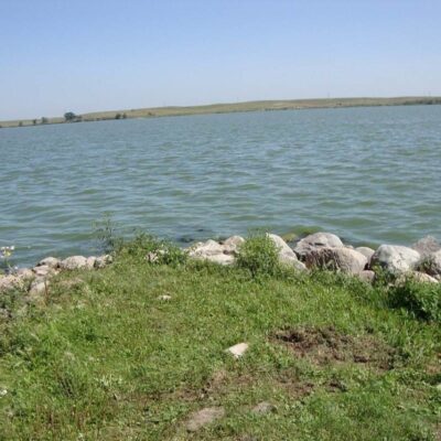
West Pollock Recreation Area provides access to the northern reaches of Lake Oahe near the town of Pollock — close to the North Dakota border. This section of Oahe is less developed and less visited than the southern reaches near Pierre, offering a more remote experience. The area lies within the historic territory of the Arikara Nation — earth-lodge-dwelling farmers who lived along the Missouri for centuries before smallpox epidemics in 1780–1781 devastated their population (estimated 80% mortality). The Arikara, along with the Mandan and Hidatsa, now form the Three Affiliated Tribes at Fort Berthold.
Visitor Information
| Detail | Information |
|---|---|
| Location | Campbell County, SD (near ND border) |
| Entry Fee | SD Park Entrance License required |
| Lake | Northern Oahe — remote! |
| History | Arikara territory — 80% smallpox loss! |
About West Pollock
West Pollock Recreation Area in Campbell County provides Missouri River recreation on Lake Oahe near the North Dakota border — the northernmost recreation area in South Dakota’s Missouri River corridor. The area offers fishing and camping in the remote northern prairie where South Dakota meets North Dakota.
Things to Do
Fishing for walleye and northern pike on Lake Oahe, camping, boating, and experiencing the vast northern Great Plains landscape at the top of South Dakota.
Insider Tips
Lake Oahe: West Pollock sits on Lake Oahe — at 231 miles long, one of the largest man-made lakes in the US. Pro tip: Oahe Dam (1962) flooded 160,000 acres of Standing Rock and Cheyenne River reservation land — destroying timber, bottomland, and communities. Treaty violation: The dam’s construction is considered one of the most devastating acts against Native Americans in the 20th century.
Best Time to Visit
Summer: Fishing and boating on vast Oahe. Fall: Less crowded — excellent fishing. Spring: Walleye run. Winter: Ice fishing on the reservoir.
Frequently Asked Questions
How did the dams affect Native Americans?
The Missouri River dams (1940s-1960s) flooded 550+ square miles of reservation land — the most fertile, timbered bottomlands where Native communities had lived for centuries. Over 900 Native American families were forcibly relocated. The Pick-Sloan Plan, which authorized the dams, was described as “one of the most destructive acts perpetrated on any people by the United States.” The tribes received minimal compensation for their losses.
Nearby state parks: If you have extra time, Swan Creek Recreation Area is within about an hour’s drive, and Lake Hiddenwood Recreation Area is within about an hour’s drive.
Wildlife & Nature
West Pollock RA — on Lake Oahe in north-central South Dakota. The area’s prairie, lake, and river breaks support bald eagles, mule deer, and ring-necked pheasants. Walleye fishing is excellent.
Nearby Attractions
Pollock — adjacent. Campbell County — surrounding. Standing Rock Reservation — nearby.