Waimea Canyon State Park
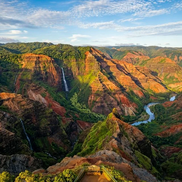
🏆 The Grand Canyon of the Pacific — 10 miles long, 3,000 feet deep, carved by the Waimea River into Kauai’s volcanic heart — one of the most dramatic landscapes on Earth
Why Waimea Canyon Will Leave You Speechless
Mark Twain reportedly called it “the Grand Canyon of the Pacific,” and while that comparison sets expectations impossibly high, Waimea Canyon somehow exceeds them. The first time you pull up to the Waimea Canyon Lookout and step out of your car, the ground simply disappears. A chasm ten miles long and 3,000 feet deep opens before you, its walls painted in layers of red, orange, green, and purple — volcanic rock eroded into spires, ridges, and amphitheaters that catch the Pacific light in ways that change minute by minute.
This 1,866-acre state park on Kauai’s western side protects one of the geological wonders of the Pacific. The canyon was carved over millions of years by the Waimea River and a massive geological fault that cracked the island’s volcanic shield, creating a rift that rain and time deepened into the spectacular gorge you see today. The layers of exposed rock tell Kauai’s volcanic story — from ancient lava flows to more recent eruptions, each layer a different shade depending on its mineral content and age.
The Lookouts: Your Gateway to the Canyon
Most visitors experience Waimea Canyon from a series of lookouts along Hawaii Route 550, which climbs from sea level near Waimea town to over 4,000 feet at the road’s terminus. Each lookout reveals a different perspective of the canyon and the surrounding landscape.
| Lookout | Mile Marker | Elevation | What You’ll See |
|---|---|---|---|
| Waimea Canyon Lookout | MM 10 | 3,400 ft | Most expansive canyon view; the “postcard” spot |
| Pu’u Ka Pele Lookout | MM 12 | 3,500 ft | Narrow canyon view with waterfall (after rain) |
| Pu’u Hinahina Lookout | MM 13 | 3,665 ft | Canyon + Ni’ihau island visible on clear days |
| Kalalau Valley Lookout | MM 18 | 4,000 ft | Na Pali Coast cliffs dropping to the ocean |
| Pu’u o Kila Lookout | End of road | 4,100 ft | Kalalau Valley from above; trailhead for Pihea |
📸 Photography Guide: Waimea Canyon
• Best Light: Morning (8-10 AM) for warm light hitting the east-facing canyon walls. Afternoon light creates deep shadows that obscure detail.
• Cloud Strategy: Clouds form quickly in this area. If cloudy at the top (Kalalau), start there and work down. The lower lookouts often stay clear longer.
• Equipment: Wide-angle (16-35mm) for the full canyon sweep; telephoto (100-400mm) for isolating individual ridges and waterfalls. Polarizing filter essential.
• Weather Window: Morning is almost always clearer. By 2 PM, clouds and mist frequently obscure canyon views. Plan to arrive by 9 AM.
Hiking Waimea Canyon
While the lookouts deliver stunning views, the hiking trails in and around Waimea Canyon offer something the roadside stops never can: solitude, perspective, and the visceral feeling of being inside this geological masterpiece rather than looking down at it from above.
| Trail | Distance | Difficulty | Highlights |
|---|---|---|---|
| Canyon Trail | 3.4 mi RT | Moderate | Descends to Waipo’o Falls overlook; canyon floor views |
| Cliff Trail | 0.2 mi | Easy | Canyon rim walk; dramatic cliff-edge perspectives |
| Kaluapuhi Trail | 2.5 mi RT | Easy | Moist forest; plum trees; mountain views |
| Pihea Trail | 3.8 mi RT | Difficult | Kalalau Valley rim; connects to Alaka’i Swamp |
| Alaka’i Swamp Trail | 7.0 mi RT | Difficult | World’s highest-elevation swamp; native bird habitat; boardwalk |
| Kukui Trail | 5.0 mi RT | Strenuous | Descends 2,000 ft to canyon floor and Waimea River |
The Canyon Trail to the Waipo’o Falls overlook is the single best hiking experience for most visitors — moderately challenging, completed in 2-3 hours, and rewarded with views of a dual waterfall plunging 800 feet into the canyon while the red-walled amphitheater stretches out below you. Start early, bring a full liter of water per person, and wear shoes with good traction — the red dirt turns slippery after rain.
The Alaka’i Swamp: World’s Highest Bog
At the summit of Mount Wai’ale’ale — one of the wettest spots on Earth with over 400 inches of annual rainfall — sits the Alaka’i Swamp, the world’s highest-elevation bog at approximately 4,000 feet. This surreal landscape of dwarf ‘ohi’a trees, mossy bogs, and endemic plants is accessible via the Pihea-Alaka’i Trail, which uses extensive boardwalks to protect the fragile ecosystem and your boots.
The Alaka’i is one of the last refuges for several critically endangered Hawaiian forest birds. Listen for the distinctive calls of the ‘apapane (crimson honeycreeper), ‘amakihi, and the extremely rare ‘akikiki (Kauai creeper), of which fewer than 500 individuals remain in the wild. Birding here requires patience, quiet movement, and often a willingness to stand still in mist-shrouded forest waiting for movement in the canopy.
Hawaiian Natural History
| Species | Status | Where to See | Notes |
|---|---|---|---|
| 🐦 Nene (Hawaiian Goose) | Endangered | Roadsides, lookout areas | State bird; do not feed |
| �� ‘Apapane | Common | Alaka’i Swamp, forest trails | Crimson honeycreeper; active, vocal |
| 🐦 ‘Akikiki (Kauai Creeper) | Critically Endangered | Upper Alaka’i only | Fewer than 500 remain; extremely rare sighting |
| 🌺 Mokihana | Protected | Alaka’i cloud forest | Kauai’s official plant; anise-scented berry |
| 🐐 Feral Goats | Invasive | Canyon walls | Commonly seen on steep slopes; destructive to native plants |
Best Time to Visit Waimea Canyon
| Season | Weather | Crowds | Best For |
|---|---|---|---|
| Summer (May-Sep) | 70-80°F (lower at lookouts) | High | Driest conditions; clearest canyon views |
| Winter (Oct-Apr) | 60-75°F | Moderate | Waterfalls most dramatic; lush canyon colors |
Summer offers the most reliable viewing conditions — clear morning skies with clouds building in the afternoon. Winter brings more rain (this is one of the wettest places on Earth, after all), which means more dramatic waterfalls cascading down the canyon walls and lusher green vegetation contrasting with the red rock. The trade-off is that winter cloud cover can obscure views entirely for days at a time. Regardless of season, arrive before 10 AM for the best visibility.
Budget Planning: Waimea Canyon
| Expense | Self-Drive Day | Guided Tour | Multi-Day (w/ Koke’e) |
|---|---|---|---|
| Park Entry | $5/person or $10/vehicle | Included in tour | $5/person |
| Parking | Included with entry | Included | Included |
| Tour Cost | — | $100-$200/person | — |
| Koke’e Lodge Cabins | — | — | $80-$120/night |
| Total (per person) | $5-$10 | $100-$200 | $165-$370 |
🌧️ Why Waimea Canyon Exists
Kauai is the oldest major Hawaiian island (~5 million years), and Waimea Canyon formed through two forces: a massive geological fault that split the island’s volcanic shield, and millions of years of erosion by the Waimea River fed by Mount Wai’ale’ale’s extraordinary rainfall (averaging 460 inches per year at its summit). The exposed rock layers — ranging from deep red (iron-rich basalt) to green (weathered minerals) to black (recent lava flows) — create the canyon’s extraordinary color palette.
Nearby Attractions
Waimea Canyon shares Highway 550 with Koke’e State Park — most visitors experience both in a single drive. Koke’e offers the Koke’e Museum, additional trails, and the Kalalau Lookout. The small town of Waimea at the canyon’s base has historical significance as the site of Captain James Cook’s first landing in Hawaii in 1778. The Waimea Plantation Cottages and Ishihara Market (famous for poke) make excellent bookends to a canyon day trip.
🌋 Ready to See the Grand Canyon of the Pacific?
Experience the dramatic volcanic canyon carved 3,000 feet deep into Kauai’s ancient lava.
Frequently Asked Questions
How long should I spend at Waimea Canyon?
For the lookouts alone, 2-3 hours is sufficient to drive the route, stop at each viewpoint, and take photos. Add 2-3 hours for the Canyon Trail hike to the Waipo’o Falls overlook, or a full day if you plan to hike the Pihea Trail into the Alaka’i Swamp. Most visitors combine Waimea Canyon with Koke’e State Park in a single half-day or full-day trip, spending 4-6 hours total between both parks.
Is Waimea Canyon free to visit?
No. Hawaii State Parks charges a $5 per person entry fee (Hawaii residents enter free with valid ID). Vehicle parking is included with entry. The fee is collected at the entry station near the bottom of the canyon road.
When is the best time of day to visit?
Morning, without question. Arrive by 9 AM for the best visibility. Clouds typically begin forming by late morning and often obscure canyon views by afternoon, especially at the upper lookouts (Kalalau, Pu’u o Kila). Morning light also provides the warmest illumination on the canyon walls, creating the best photography conditions. If you see clouds forming, work from the top down — start at Kalalau Lookout and drive back down to the lower (often clearer) canyon lookouts.
Can you drive to the bottom of Waimea Canyon?
No. The only road access is along the canyon rim via Highway 550. To reach the canyon floor, you must hike the strenuous Kukui Trail, which descends approximately 2,000 feet over 2.5 miles. This trail is steep, exposed, and demanding — the return climb can take 2-3 hours in tropical heat. Most visitors are better served by the Canyon Trail, which offers excellent canyon views without the brutal elevation change.
What should I wear to Waimea Canyon?
Layers are essential. Temperatures at the lookouts (3,500-4,100 feet elevation) are typically 10-15°F cooler than at sea level. Bring a light jacket or fleece, especially for early morning visits. If hiking, wear sturdy closed-toe shoes with good traction — the red clay trails become extremely slippery when wet. The Alaka’i Swamp trail is muddy regardless of conditions, so waterproof hiking shoes or boots are advisable. Sun protection (hat, sunscreen) is important despite the cooler temperatures at elevation.