🌤 Weather at Memaloose State Park by season
| Spring | Summer | Fall | Winter |
|---|---|---|---|
| 34–73 °F | 53–89 °F | 33–81 °F | 29–49 °F |
Each range runs from the coldest monthly average low to the warmest monthly average high in that season (1991-2020 climate normals), measured at The Dalles, 9 mi away, elevation 150 ft. Conditions at the park can differ from the station, especially where elevation differs — check a forecast before you go.
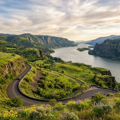
Camp in the Columbia Gorge — Sacred Island Views, River Bluffs & World-Class Wind Country
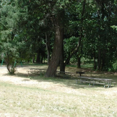
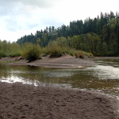
Memaloose State Park sits on a bluff above the Columbia River in the heart of the Columbia River Gorge National Scenic Area, approximately 11 miles west of The Dalles and near the small community of Mosier in north-central Oregon. The park offers 110 campsites in a grassy, tree-shaded setting with views across the river to Washington State and — critically — to Memaloose Island, the park’s namesake and one of the most culturally significant sites on the Columbia.
The name tells the story: “Memaloose” derives from the Chinook Jargon term “memaloose illahee” — “land of the dead.” For centuries, indigenous peoples placed their dead on the island in canoes and on open pyres, making it a sacred burial ground visible from the campground. Much of the original island was submerged following the construction of Bonneville Dam in the 1930s — only about a third remains visible today. The island is closed to public access, but its presence gives Memaloose a depth of significance that most highway campgrounds never approach.
Things to Do
Camping with Columbia Gorge Views
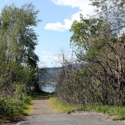
The primary draw: sleeping in the Gorge itself. The park’s grassy, maple-and-cottonwood-shaded campground sits on a bluff overlooking the river with views of Memaloose Island and the Washington side of the Gorge.
Gorge Windsurfing & Kiteboarding Base Camp
While the park itself has no direct river access (the bank is steep and there’s no safe path to the water), Memaloose is perfectly positioned as a base camp for wind sports:
- Hood River (world-class windsurfing/kiteboarding capital) is 20 minutes west
- Mayer State Park (boat ramp and river access) is nearby
- The Dalles area launch sites are 11 miles east
Scenic Drives
The park sits directly on the Historic Columbia River Highway corridor. From here, you’re positioned for:
- Mosier Twin Tunnels Trail — an easy paved trail through restored highway tunnels with Gorge views
- Rowena Crest Viewpoint — dramatic overlook of Rowena Loops and the eastern Gorge
- Columbia Gorge Discovery Center in The Dalles — regional history and geology museum
Memaloose Island History
The island visible from the campground was a sacred burial ground for Columbia River peoples for centuries. A granite monument to Victor Trevitt, an early pioneer, is also on the island. The island is closed to public access — it’s best appreciated from the campground bluff or by boat (maintaining respectful distance).
Camping
| Type | Sites | Amenities |
|---|---|---|
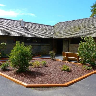
| Full Hookup Sites | 44 | Water, electric, sewer; modern restrooms; showers |
| Tent Sites | 66 | Grassy pads; fire rings; picnic tables; restroom access |
Best Time to Visit
| Season | Highlights | Considerations |
|---|---|---|
| Summer (Jun–Aug) | ⭐ Peak wind sports season; warm camping; longest days; Gorge wildflowers | Windy! (that’s the point); book early; hot eastern Gorge temps |
| Fall (Sep–Oct) | ⭐ Golden cottonwoods; warm days; wind season continuing; fewer crowds | Campground may close late Oct; cooler nights |
| Spring (Apr–May) | Gorge wildflower season; green hills; waterfalls at peak flow | Rain common; windy; some facilities opening; variable weather |
| Winter (Nov–Mar) | Closed for camping | Park campground typically closed for the season |
Visitor Tips
- ⚠️ Access is WESTBOUND ONLY: Memaloose State Park can only be reached from the westbound lanes of Interstate 84. If you are traveling eastbound, you must continue to Exit 76, turn around, and return westbound to reach the park entrance. Plan your approach accordingly.
- Train and highway noise: The park sits between I-84 and an active railroad line. Expect train horns and traffic noise at all hours. Bring earplugs if you’re a light sleeper — the views are worth it.
- No river access: There is no safe or legal access to the Columbia River from the campground. For swimming, boating, or windsurfing launches, use nearby Mayer State Park or Hood River facilities.
- Cultural sensitivity: Memaloose Island is a sacred burial ground. The island is closed to public access. Please observe it respectfully from shore.
- Gorge wind: The Columbia Gorge funnels powerful winds through this corridor. Secure your tent, canopy, and gear — unexpected gusts are common, especially in afternoon.
Frequently Asked Questions
Wildlife & Nature
Memaloose SP — in the Columbia River Gorge. The name derives from the Chinook word for “to die” — Memaloose Island was a sacred Native American burial site. The park’s Gorge terrain, oak woodlands, and river support bald eagles, osprey, and Lewis’s woodpeckers.
Nearby Attractions
The Dalles — 10 miles east — site of the historic Columbia River portage. Columbia River Gorge NSA — surrounding. Rowena Crest — 5 miles east.
How do you access Memaloose State Park from eastbound I-84?
Memaloose State Park is only accessible from the westbound lanes of Interstate 84. If you are traveling eastbound, you cannot access the park directly. Continue to Exit 76 (or the next available exit), turn around to travel westbound, and the park entrance will be on your right. This is a common point of confusion — plan your route in advance, especially if towing a trailer.
Can you swim in the Columbia River at Memaloose State Park?
No — there is no safe or legal access to the Columbia River from Memaloose State Park. The campground sits on a bluff above the river with steep banks. For river access, swimming, and boat launches, visit nearby Mayer State Park or the Hood River waterfront, both within a short drive.
Last updated: April 2026
Keep exploring: The closest neighbors are Mayer State Park (a short drive away) and Koberg Beach State Recreation Site (a short drive away).
Camping reservations: Book campsites and cabins for Oregon state parks online at oregonstateparks.reserveamerica.com.

🐾 Dogs & Pets at Memaloose State Park
- Pets allowed? statewide rule
- Pets are welcome in Oregon state parks and on most ocean beaches but must be leashed except in designated off-leash areas.
- Leash rule statewide rule
- Leash no longer than 6 feet required in developed park areas
- Beaches & swim areas statewide rule
- Pets are allowed on most ocean beaches under direct control; western snowy plover nesting areas restrict pets March 15 - Sept. 15; leash required on the beach at some parks (e.g. Cape Lookout)
- Cabins & lodging statewide rule
- Designated pet-friendly yurts and cabins at many parks (South Beach has 14 pet-friendly yurts, Tugman 8); maximum two dogs and/or cats; $10 per night pet fee
- Pet fees statewide rule
- $10 per night for pet-friendly yurts/cabins; no pet fee for day use or campsites
- Statewide exceptions statewide rule
- Pets prohibited at Dabney SRA, the Trail of Ten Falls at Silver Falls, and Shore Acres; off-leash areas at Stub Stewart, Willamette Mission, Elijah Bristow, Cottonwood Canyon and LaPine
Are dogs allowed at Memaloose State Park?
Pets are welcome in Oregon state parks and on most ocean beaches but must be leashed except in designated off-leash areas. Individual parks can post stricter rules — check signage on arrival.
Rules verified July 2026 via stateparks.oregon.gov. More: Oregon state parks guide · Dog rules in all 50 states compared
Park Location
Plan your gear for Memaloose State Park
From our editorial guides, matched to this park’s activities: