Silver Falls State Park
Silver Falls State Park: Oregon’s Crown Jewel
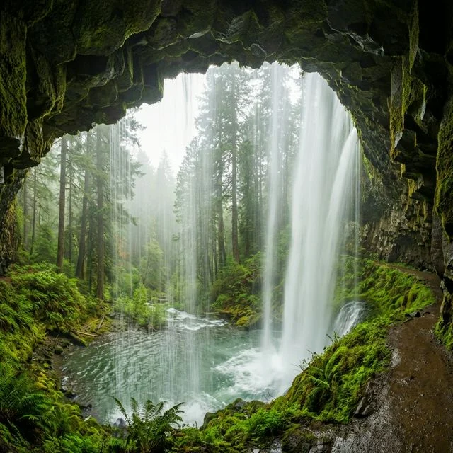
In the foothills of Oregon’s Cascade Range, Silver Falls State Park protects 9,200 acres of ancient forest, basalt canyons, and the most spectacular concentration of waterfalls in the Pacific Northwest. The park’s legendary Trail of Ten Falls — a 7.2-mile loop passing ten distinct waterfalls — is one of the most acclaimed hiking trails in the United States, with four waterfalls you can walk behind.
Known as the “Crown Jewel” of the Oregon State Parks system, Silver Falls combines world-class waterfall hiking with CCC-era historic architecture, old-growth forest, 35+ miles of mountain biking trails, and 20+ miles of equestrian trails. Located just 40 minutes east of Salem and 90 minutes from Portland, it’s the most visited state park in Oregon — and one of the most extraordinary natural areas in the American West.
Park Facts at a Glance
| Information | Details |
|---|---|
| 📍 Location | Near Silverton, Marion County, Oregon |
| 📐 Park Size | 9,200+ acres (largest state park in Oregon) |
| 🌊 Waterfalls | 15 total (10 on the Trail of Ten Falls) |
| 🥾 Total Trail Miles | 35+ miles hiking, 35+ biking, 20+ equestrian |
| 🏕️ Camping | 48 electric + 43 tent sites + 14 cabins + group sites |
| 🐴 Horse Camp | Howard Creek Horse Camp with corrals |
| 💰 Day-Use Parking | $10/vehicle |
| 🕐 Hours | Open year-round, dawn to dusk |
| 📞 Phone | (503) 873-8681 |
| 🌐 Website | oregonstateparks.org |
| 📍 Address | 20024 Silver Falls Hwy SE, Sublimity, OR 97385 |
History: From Kalapuya Homelands to Oregon’s Crown Jewel
The forests and canyons of Silver Falls have been homeland for thousands of years. The Kalapuya and Molala peoples were the original inhabitants, using the area for hunting, gathering, and spiritual quests long before European contact. The fertile valleys and sheltering canyons supported seasonal camps, and the waterfalls held cultural significance for these First Nations communities. They were forcibly displaced by European settlers in the mid-19th century.
By the 1880s, logging operations had moved into the area. A small town called Silver Falls formed near South Falls around 1888, primarily as a logging community. The extensive timber harvest significantly altered the ancient landscape, leaving many areas scarred and cleared.
The preservation movement began in earnest in 1931, when local photographer June Drake — for whom Drake Falls is named — spearheaded a campaign to purchase the land around the waterfalls for public use. Her advocacy, combined with growing public support, succeeded: Silver Falls State Park was officially established in 1933. In 1935, President Franklin D. Roosevelt designated the area as a Recreational Demonstration Area (RDA), bringing federal resources and CCC labor to the devastated landscape.
The Civilian Conservation Corps (CCC) transformed the park from 1933 to 1942. Their work was remarkable: they rehabilitated the logged forest by replanting thousands of trees, constructed the trail system to the waterfalls, built bridges, widened natural pathways behind several waterfalls to make them accessible, and completed the stunning South Falls Lodge in the late 1930s — a structure now listed on the National Register of Historic Places. Today, the forest feels ancient because of how successfully the CCC and natural regrowth healed the land.
Geology: Columbia River Basalt and the Birth of Waterfalls
The geology of Silver Falls State Park tells a 26-million-year story of oceans, volcanism, and erosion that created the distinctive waterfall landscape visible today.
During the Oligocene period (roughly 26 million years ago), much of western Oregon was submerged beneath an ocean. Marine sediments — sandstones and siltstones — accumulated on the seafloor over millions of years, forming the oldest rock layer visible at Silver Falls today.
The transformative geological event came approximately 15 million years ago, when massive Columbia River Basalt Group flood lava flows erupted from fissures in eastern Oregon and Washington. These were among the largest volcanic events in Earth’s history — individual flows traveled hundreds of miles, burying everything in their path under layers of hard basalt. Silver Falls sits near the southern limit of these vast basalt flows.
Multiple distinct basalt flows accumulated at Silver Falls, creating a geological layer cake visible in the canyon walls:
- Grande Ronde Basalt (lower): Both Low-Mg and High-Mg chemical types — the oldest and thickest flow layers
- Wanapum Basalt — Frenchman Springs Member (upper): Younger flow capping the canyon rims
- Marine sediments (base): The original Oligocene-era sandstone beneath the basalt — softer and more erodible
The waterfalls formed where Silver Creek eroded down through the hard basalt cap and reached the softer marine sediments below. Water undercuts the soft rock, causing the harder basalt above to overhang and eventually break off — creating the classic amphitheater shape that allows visitors to walk behind four of the falls. The basalt layers dip slightly west-southwest, forming part of an open anticline, which influences the drainage pattern of both the North and South Forks of Silver Creek.
Trail of Ten Falls: Complete Waterfall Guide
The Trail of Ten Falls is the centerpiece of Silver Falls State Park and one of the most celebrated hiking trails in the United States. This 7.2-mile loop follows the canyons of the North and South Forks of Silver Creek past ten distinct waterfalls, ranging from 27 to 178 feet in height. Four of these waterfalls allow you to walk behind the curtain of water on trails carved into the cliff face — an experience found almost nowhere else in America.
| Waterfall | Height | Walk Behind? | Highlight |
|---|---|---|---|
| ⭐ South Falls | 177 ft | ✅ Yes | The iconic falls — widest amphitheater, most dramatic walk-behind experience |
| Lower South Falls | 93 ft | ✅ Yes | Second walk-behind on the South Fork, lush grotto setting |
| Lower North Falls | 30 ft | No | Smallest but charming cascade over mossy rocks |
| ⭐ Double Falls | 178 ft | No | Tallest waterfall in the park — dramatic two-tier plunge |
| Drake Falls | 27 ft | No | Named for photographer June Drake who championed the park |
| Middle North Falls | 106 ft | ✅ Yes | Third walk-behind — wide basalt amphitheater in deep canyon |
| Twin Falls | 31 ft | No | Two parallel cascades side by side |
| ⭐ North Falls | 136 ft | ✅ Yes | Fourth walk-behind — massive basalt overhang, thunderous plunge |
| Upper North Falls | 65 ft | No | Beautiful curtain-style waterfall in quieter section |
| Winter Falls | 134 ft | No | Seasonal — most impressive after rain or snowmelt |
Trail Details
- Full Loop Distance: 7.2–8.6 miles depending on route
- Elevation Gain: 800–1,480 feet
- Difficulty: Moderate (rock stairs, some steep descents into canyons)
- Time: 3–6 hours for the full loop
- Start Points: South Falls parking ($10) or North Falls parking ($10)
- Direction: Most hike clockwise from South Falls
- Pets: NOT allowed on the Canyon Trail or any trails leading into the canyon
Shorter Options
| Route | Distance | Waterfalls | Best For |
|---|---|---|---|
| South Falls Loop | 0.9 mi | 1 (South Falls — walk behind) | Families, limited time, accessibility |
| North Falls Loop | 1.3 mi | 2 (North Falls + Upper North Falls) | Another quick walk-behind experience |
| Maple Ridge Loop | 2.6 mi | 2 (South Falls + Lower South Falls) | Two walk-behinds without the full loop |
Beyond Waterfalls: Biking, Horseback Riding & More
Silver Falls is far more than its famous waterfall trail. The park’s 9,200 acres deliver one of Oregon’s most diverse outdoor recreation portfolios.
| Activity | Trail Miles | Details |
|---|---|---|
| 🚵 Mountain Biking | 35+ miles | Forested singletrack: Catamount Trail, Buck Mountain Loop, Perimeter Loop. All skill levels. Newt Loop Skills Area for beginners. |
| 🚲 Paved Bike Path | 5.2 miles | Family-friendly, flat. Does not pass waterfalls. |
| 🐴 Horseback Riding | 20+ miles | Buck Mountain Loop, Howard Creek/Buck Mountain, Rackett Ridge/Perimeter. BYOH (bring your own horse). Not on Trail of Ten Falls. |
| 🏃 Trail Running | 35+ miles | Same backcountry trails as MTB. Rolling terrain through forest. |
| 🧒 Playground & Picnic | — | South Falls Day-Use Area: lawns, BBQ stands, shelters, horseshoe pits, off-leash dog area. |
| 🏛️ Historic Lodge | — | CCC-built South Falls Lodge — café, warm food, snacks. National Register of Historic Places. |
Camping & Cabins
Silver Falls offers year-round camping and cabin accommodations in a stunning old-growth forest setting. The campground is separated from the main waterfall trail area, providing a peaceful wooded atmosphere. Reservations can be made up to 6 months in advance via oregonstateparks.reserveamerica.com.
| Option | Sites | Cost/Night (2025) | Features |
|---|---|---|---|
| Electric Sites (W/E) | 48 | $32–$36 | Water + electricity. $32 off-season / $36 summer (May–Sep) |
| Tent Sites | 43 | ~$22–$25 | Tent-only, no hookups. Seasonal pricing applies. |
| Cabins | 14 | ~$72–$129 | 7 are pet-friendly. Year-round. Rustic to deluxe. Must reserve. |
| Group Camps | 2 | Varies | Large group reservations available |
| Horse Camp | Several | Varies | Howard Creek Horse Camp — steel corrals, reservations required |
| Smith Creek Village | Multiple | Varies | Cabins, cottages, lodges. Near southern park edge. Check for seasonal discounts. |
Additional fees: Online reservation fee is $10. Extra vehicle fee is $10/night per additional vehicle. Day-use parking is $10/vehicle separate from camping fees.
Seasonal Guide
| Season | Highlights | Insider Tips |
|---|---|---|
| 🌸 Spring (Mar–May) | Waterfalls at peak flow, wildflowers, bright green forest, dramatic canyon mist | Best waterfall photography — maximum volume and drama. Some trail sections may be slippery near spray zones. |
| ☀️ Summer (Jun–Sep) | Peak visitor season, longest days, warmest temps (70s–80s°F), all trails fully open | Arrive before 9 AM on weekends — parking fills by late morning. Weekday visits are significantly less crowded. |
| 🍂 Fall (Oct–Nov) | Stunning golden and orange maple canopy, moderate waterfall flow, fewer crowds | October is the sweet spot — fall color, lighter crowds, comfortable hiking temps. Big-leaf maples turn brilliant yellow-gold. |
| ❄️ Winter (Dec–Feb) | Dramatic atmosphere — misty waterfalls, moss-draped forest, occasional snow/ice on basalt | ⚠️ Trails can be icy and very slippery near waterfalls. Use traction devices. Fewer visitors — moody, atmospheric photography. |
Photography Guide
Silver Falls is one of the most photographed natural areas in the Pacific Northwest — the combination of towering waterfalls, moss-covered basalt, cathedral forest, and perpetual canyon mist creates extraordinary conditions in every season.
- Best Shot: South Falls from behind the curtain — the 177-foot cascade framed by the basalt amphitheater with the green canyon below. Use a slow shutter speed (1/8–1 sec) with a tripod for silky water
- Polarizing Filter: Essential for controlling reflections on wet basalt and enhancing the green tones of moss and fern
- Walk-Behind Shots: Photograph from behind all four walk-behind waterfalls — each has a different character. North Falls has the most dramatic overhang, Middle North Falls the widest amphitheater
- Light: Canyon floors are perpetually shaded — ideal for soft, even light without harsh shadows. Overcast days are perfect. Avoid midday direct sun, which creates extreme contrast
- Fall Foliage: Late October — bigleaf maples create golden canopy throughout the canyon. Lower South Falls and the connector trails have the best autumn color
- Winter Mood: Frost on basalt columns, icicles on cliff faces, bare maple branches against misty falls — moody and dramatic. Bring rain protection for gear
- Lens: Wide-angle (16–35mm) for canyon amphitheaters and walk-behind framing. A longer lens (70–200mm) isolates individual cascade details and mossy textures
Nearby Attractions
| Attraction | Distance | Why Visit |
|---|---|---|
| Silverton (town) | 15 miles | Charming “Oregon’s Garden City” — Oregon Garden, Enchanted Forest, restaurants, lodging |
| Oregon Garden Resort | 15 miles | 80-acre botanical garden with Gordon House (only Frank Lloyd Wright house in Oregon) |
| Willamette Valley Wine Country | 25 miles | World-class Pinot Noir wineries and tasting rooms |
| Salem (state capital) | 25 miles | State Capitol, Bush’s Pasture Park, dining, hotels |
| Mount Angel Abbey | 20 miles | Hilltop Benedictine monastery, annual Oktoberfest |
| Abiqua Falls | 15 miles | Dramatic 92-ft basalt amphitheater waterfall — requires rough road access |
| Portland | 75 miles | ~90 minutes. Nearest major city for flights, dining, culture |
| Breitenbush Hot Springs | 50 miles | Remote natural hot springs retreat in the Cascades |
Pro Tips from Experienced Visitors
- ⏰ Arrive Early: The South Falls parking lot fills by 10 AM on summer weekends. Arrive before 9 AM — or hike on a weekday for virtually empty trails
- 🔄 Clockwise from South Falls: Most experienced hikers recommend starting at South Falls and going clockwise. You’ll hit the most dramatic walk-behinds first and finish with a relatively flat return
- 📍 North Falls Start: If South Falls parking is full, drive to the North Falls trailhead. You’ll begin with North Falls (walk-behind) and Upper North Falls, then loop through the rest
- 🧥 Rain Jacket Always: Even on sunny days, you will get wet walking behind the waterfalls. A packable rain jacket is essential year-round
- 👟 Traction in Winter: From November through March, carry microspikes or traction devices. The basalt trails near waterfalls get extremely slippery with ice and spray
- 🐕 No Dogs on Waterfall Trail: Pets are NOT allowed on the Trail of Ten Falls or canyon trails. They ARE permitted on the Rim Trail and paved paths. Plan accordingly.
- 🍔 South Falls Lodge: The CCC-era lodge has a café with hot food and snacks — a welcome stop before or after the hike. Check seasonal hours.
- 🚗 Annual Pass Math: At $10/visit, the annual parking pass ($60 Oregon / $75 out-of-state) pays for itself after 6–8 visits. Essential for locals and frequent hikers.
Safety & Park Rules
- Slippery surfaces: The basalt trails near waterfalls are perpetually wet from spray. Rock stairs can be extremely slippery, especially in winter. Use traction devices from November to March
- Stay on trail: Cliff edges are unstable, and the basalt undercuts. Multiple injuries have occurred from off-trail exploration. Stay behind guardrails and fencing
- Water crossings: Some creek crossings can be challenging during high water (winter/spring). Waterproof boots recommended year-round
- Hypothermia risk: Walking behind waterfalls drenches clothing. In winter, this creates a real hypothermia risk. Layer synthetics (not cotton) and carry a dry layer
- No pets on canyon trails: Enforced with fines. Leashed pets only on Rim Trail and paved paths
- Pack out trash: No trash cans on the trail itself. Carry out everything you bring in
Getting There
| From | Distance | Drive Time | Route |
|---|---|---|---|
| Salem, OR | 25 miles | ~40 min | OR-22 East to OR-214 South |
| Portland, OR | 75 miles | ~90 min | I-5 South to OR-22 East to OR-214 |
| Eugene, OR | 110 miles | ~2 hours | I-5 North to OR-22 East |
| Bend, OR | 150 miles | ~3 hours | US-20 West to OR-22 West to OR-214 |
| Silverton, OR | 15 miles | ~20 min | OR-214 South directly to park |
Address: 20024 Silver Falls Hwy SE, Sublimity, OR 97385
Frequently Asked Questions
How long does the Trail of Ten Falls take?
The full Trail of Ten Falls loop is 7.2–8.6 miles (depending on route) and typically takes 3–6 hours to complete. The pace depends largely on how long you spend at each waterfall — most hikers linger at the walk-behind falls. The trail is rated moderate with 800–1,480 feet of elevation gain, including rock stairways descending into the canyon. If you only want to see one or two waterfalls, shorter loops are available: the South Falls loop is just 0.9 miles, and the North Falls loop is 1.3 miles.
Can you really walk behind the waterfalls?
Yes — four of the ten waterfalls on the trail have paths carved behind them: South Falls (177 ft), Lower South Falls (93 ft), Middle North Falls (106 ft), and North Falls (136 ft). The trails pass through basalt amphitheaters where the softer rock beneath the hard basalt cap has eroded away, creating natural alcoves. You will get wet from spray, so a rain jacket is recommended. The CCC widened these natural pathways in the 1930s to make them safely accessible.
Are dogs allowed at Silver Falls State Park?
Dogs are NOT allowed on the Trail of Ten Falls (Canyon Trail) or on trails leading into the canyon, including the Maple Ridge, Winter Falls, and Twin Falls trails. This is strictly enforced with fines. Leashed dogs ARE permitted on the Rim Trail, paved paths, and in the campground/day-use areas. The South Falls Day-Use Area even has an off-leash dog area. Seven of the 14 cabins in the campground are pet-friendly.
How much does it cost to visit Silver Falls State Park?
Day-use parking costs $10 per vehicle (as of 2025). There is no per-person admission fee — just the vehicle parking fee. Camping ranges from approximately $22–$36/night depending on site type and season, with cabins ranging from $72–$129/night. An Oregon annual parking permit costs $60 for residents ($75 out-of-state, starting Jan 2026) and covers all Oregon state parks.
What is the best time to visit Silver Falls State Park?
Every season has its appeal. Spring (March–May) delivers the most powerful waterfalls at peak flow with lush green canyon walls. Summer (June–September) brings the warmest weather and longest days but also the heaviest crowds — arrive early. Fall (October–November) offers stunning golden maple foliage with lighter crowds. Winter (December–February) is moody and dramatic with fewer visitors, but trails can be icy and slippery near waterfalls — traction devices are essential.
Which waterfall is the tallest at Silver Falls?
Double Falls is the tallest waterfall at Silver Falls State Park at approximately 178 feet — just one foot taller than the more famous South Falls (177 feet). While you cannot walk behind Double Falls, it’s one of the most dramatically scenic waterfalls on the trail, plunging in two distinct tiers into a deep pool. South Falls, despite being slightly shorter, is the most visited because of its accessible walk-behind trail and proximity to the main parking area.
Can you mountain bike or horseback ride at Silver Falls?
Yes — Silver Falls offers over 35 miles of mountain biking trails and 20+ miles of equestrian trails in the backcountry. Popular MTB routes include Catamount Trail, Buck Mountain Loop, and the Perimeter Loop. Beginners can use the Newt Loop Skills Area. The park also has a 5.2-mile paved bike path. For horseback riding, the Howard Creek Horse Camp provides campsites with steel corrals. However, neither bikes nor horses are allowed on the Trail of Ten Falls.
How far is Silver Falls State Park from Portland?
Silver Falls State Park is approximately 75 miles southeast of Portland, about a 90-minute drive via I-5 South to OR-22 East to OR-214 South. From Salem, it’s only 25 miles (40 minutes). The park is a popular day trip from both cities. From Eugene, it’s about 110 miles (2 hours), and from Bend it’s approximately 150 miles (3 hours) via US-20.


