Starvation Creek State Park
The name alone tells you something extraordinary happened here. Starvation Creek State Park sits at the base of towering basalt cliffs where four waterfalls cascade through moss-draped forests—but it’s the winter of 1884-1885 that gave this place its haunting name. For 21 days over Christmas, 148 passengers on the Pacific Express sat trapped in a 25-foot snowdrift while temperatures plunged and supplies dwindled. They nearly died here. They almost starved.
Today, this small but spectacular park along the Historic Columbia River Highway offers one of the Gorge’s most accessible waterfall experiences, a gateway to one of Oregon’s most punishing hikes, and a chance to stand in the exact spot where human drama and natural beauty collided in one of the Pacific Northwest’s most harrowing survival stories.
In fifteen minutes, you can walk to a 190-foot waterfall. In an hour, you can visit four falls connected by a paved pathway perfect for families. In a day, you can summit Mount Defiance and stand atop the highest point in the Columbia River Gorge, looking down at five volcanic peaks while your legs remind you why this trail has a reputation. Starvation Creek gives you options—but it never lets you forget its story.
What Makes Starvation Creek Unforgettable
Four Waterfalls
Starvation Creek Falls, Cabin Creek Falls, Hole-in-the-Wall Falls, and Lancaster Falls—all accessible from one park.
1884 Train Disaster
148 passengers stranded for 21 days in a snowdrift—rescued by locals on skis with supplies.
Mount Defiance
Oregon’s hardest Gorge hike—4,800 feet of gain to views of five Cascade volcanoes.
Historic Highway Trail
Paved path along the original 1915 Columbia River Highway—perfect for families and bikes.
The Harrowing Story Behind the Name
On December 16, 1884, the Pacific Express locomotive chugged up the Columbia River Gorge with 148 passengers aboard, steaming toward Portland through increasingly heavy snowfall. Somewhere near what we now call Starvation Creek, the train plowed into a massive snowdrift—and stopped. The drift was 25 feet deep. The locomotive couldn’t back up. The passengers were trapped.
What followed was a 21-day ordeal that became legend in the Pacific Northwest. Days turned into a week. A week turned into two. Snow continued falling. Food supplies ran desperately low. The passengers—a mix of businessmen, families, and travelers—faced the real possibility of starving to death in a freezing train car just miles from civilization.
The Rescue
Word finally reached the small community of Hood River, some ten miles east. Without roads, without search and rescue teams, without helicopters, locals did the only thing they could: they strapped on skis and set out through the storm. They arrived with food, supplies, and hope—saving every passenger aboard. On January 6, 1885, after three weeks in the snow, the survivors finally walked out.
The creek that flowed nearby was forever after called “Starveout Creek”—later softened to “Starvation Creek.” Today, a commemorative plaque in the park marks not just this drama, but also the spot where construction began on the original Columbia River Highway in 1912—the same road that would later make this landscape accessible to millions.
📜 Find the Historical Marker
The plaque commemorating the 1884 train incident and the 1912 highway construction is located near the main parking area at the viewpoint. Take a moment to read it before hitting the trails—it transforms the landscape from “pretty park” to “living history.”
The Four Waterfalls of Starvation Creek
Starvation Creek may be small, but it packs an extraordinary density of waterfalls into its compact footprint. Four distinct falls are accessible from the park—ranging from a 30-second walk to a one-hour loop—making this one of the Gorge’s best “waterfall per minute” destinations.
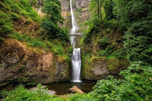
1. Starvation Creek Falls (The Star)
The park’s namesake and main attraction plunges approximately 190 feet in two elegant tiers down a moss-covered cliff face. The falls are visible almost from the parking lot, and a paved path takes you to the base viewpoint in under two minutes. After rain or during spring snowmelt, the volume is tremendous—a white veil of water that fills the canyon with thunder. By August, the flow gentles to a lacey ribbon, but the falls never disappear entirely.
| Starvation Creek Falls | Details |
|---|---|
| 📏 Height | ~190 feet (two tiers) |
| 🚶 Distance | 200 feet from parking |
| ♿ Accessibility | Paved, wheelchair/stroller accessible |
| 📷 Best Photo Spot | Viewpoint at trail end; include bridge for scale |
| 💧 Peak Flow | November – May |
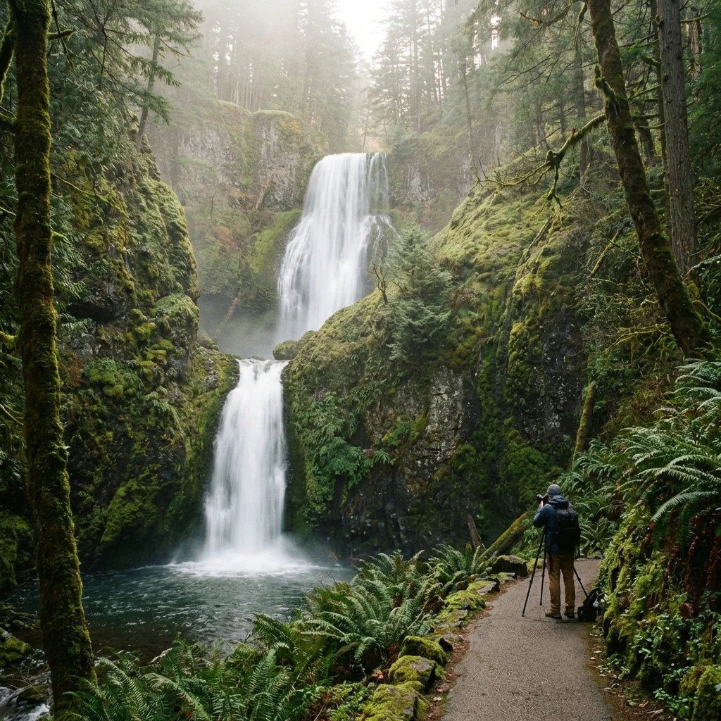
2. Cabin Creek Falls
Continue west on the paved Historic Columbia River Highway Trail for about half a mile and you’ll reach Cabin Creek Falls—a 175-foot cascade that tumbles in multiple stages through a narrow cleft. This waterfall gets less attention than Starvation Creek Falls, which means you’ll often have it to yourself. The surrounding forest is particularly lush here, with ferns and moss coating every surface.
3. Hole-in-the-Wall Falls
Perhaps the most photogenic of the four, Hole-in-the-Wall Falls has a feature unique among Gorge waterfalls: the paved trail actually passes behind the cascading water through a tunnel blasted in the rock during original highway construction. Standing in that tunnel, with water falling past the entrance and the gorge framed beyond, is a quintessential Columbia River Gorge experience.
📸 The Money Shot
For the iconic Hole-in-the-Wall photograph, position yourself inside the tunnel looking out. The water should be on your right, the gorge vista on your left. Include a person silhouetted in the frame for scale. Early morning provides even, shadow-free light; late afternoon brings golden tones but harsh contrasts.
4. Lancaster Falls
The westernmost of the four, Lancaster Falls drops over 250 feet in multiple tiers that become increasingly dramatic during peak flow. You’ll glimpse the upper portion from the trail; the full cascade is best seen from viewpoints along the Historic Highway Trail as you approach Wyeth. This is a “bonus falls”—visible but not the main attraction.
Waterfall Trail Summary
| Waterfall | Height | Distance from Parking | Unique Feature |
|---|---|---|---|
| 💧 Starvation Creek Falls | ~190 ft | 200 ft | Double-tiered, iconic view |
| 💧 Cabin Creek Falls | ~175 ft | 0.5 mi | Secluded, multi-stage |
| 💧 Hole-in-the-Wall Falls | ~100 ft | 0.8 mi | Trail passes behind falls |
| 💧 Lancaster Falls | ~250 ft | 1.5 mi | Tallest, multi-tiered |
Hiking Trails
Starvation Creek serves as a trailhead for vastly different experiences—from paved, flat family strolls to leg-destroying mountain ascents that rank among Oregon’s most challenging.
Historic Columbia River Highway State Trail
This paved path follows the original 1915 roadbed of the Columbia River Highway, offering flat, easy walking or biking with stunning Gorge views.
- 🚴 West to Wyeth: 4.6 miles one-way, passes all four waterfalls, ends at Wyeth Campground
- 🚶 East to Viento: 1.0 mile one-way, connects to Viento State Park
- ♿ Accessibility: Paved, suitable for strollers and wheelchairs
- ⚡ E-bikes: Allowed on this trail
- 🐕 Dogs: Welcome on leash
This is the trail most visitors experience—and for good reason. In under two hours, you can walk from Starvation Creek Falls to Hole-in-the-Wall Falls and back, visiting three waterfalls on a surface smooth enough for dress shoes. The views across the Columbia to the Washington cliffs are spectacular throughout.
Starvation Ridge Trail: The Challenge Begins
If the paved path feels too civilized, the Starvation Ridge Trail offers a reality check. This connector climbs steeply from the Historic Highway Trail to the Mount Defiance Trail, gaining approximately 2,000 feet in 1.5 miles. It’s steep, relentless, and merely the appetizer for what comes next.
Mount Defiance Trail: The Hardest Hike in the Gorge
There are difficult hikes, and then there’s Mount Defiance. At 4,840 feet of elevation gain over approximately 6 miles (one way), this is widely considered the most demanding trail in the Columbia River Gorge—and one of the toughest in Oregon.
| Mount Defiance Details | Statistics |
|---|---|
| 📏 Distance | ~12 miles round trip |
| 📈 Elevation Gain | 4,840 feet |
| ⏱️ Time | 6-10 hours round trip |
| ⚠️ Difficulty | Expert / Extremely Strenuous |
| 🏔️ Summit Views | Mt. Hood, Adams, St. Helens, Rainier, Jefferson |
What to Expect on Mount Defiance
The trail begins pleasantly enough through forest, but the character changes quickly. Within the first two miles, you’re climbing steeply through switchbacks that seem endless. The forest provides shade but also blocks views—you won’t know how high you’ve climbed until you break out onto rocky areas near the summit.
The payoff is extraordinary. On clear days, the summit of Mount Defiance offers views of five Cascade volcanoes: Mount Hood dominates to the south, with Mount Adams and St. Helens in Washington, and on exceptionally clear days, Rainier to the north and Jefferson to the far south. The Columbia River appears as a silver ribbon thousands of feet below. You’ll have earned every inch of that view.
⚠️ Mount Defiance is NOT for Beginners
This trail injures people every year. The elevation gain is brutal, the footing can be treacherous, and the distance means you’ll be descending on already-exhausted legs. Do not attempt if you are not in excellent physical condition. Bring at least 3 liters of water, start before dawn in summer, carry a headlamp in case you’re out after dark, and tell someone your plans.
The Photographer’s Guide
Starvation Creek offers outstanding photography opportunities for those who understand its light and moods. Here’s how to capture its best angles:
Best Shots & Timing
| Shot | Location | Best Time | Tips |
|---|---|---|---|
| 💧 Starvation Creek Falls | Main viewpoint | Overcast days; morning | Avoid harsh midday sun; 1/4 sec for silky water |
| 🕳️ Hole-in-the-Wall | Inside tunnel looking out | Early morning or late afternoon | Include silhouetted person; HDR helpful |
| 🏔️ Gorge Panorama | Trail viewpoints west of parking | Sunrise or sunset | Golden hour lights Washington cliffs |
| ⛰️ Mount Defiance Summit | Summit rocks | Clear days; avoid summer haze | Wide angle for volcano sweep |
| 🌧️ Moody Forest | Trail to Cabin Creek Falls | During rain or fog | The Gorge is magic in mist |
Technical Recommendations
- 📷 Bring a tripod: Essential for long exposures on waterfall shots
- 🌧️ Rain cover: The Gorge is wet; protect your gear
- 🔲 ND filter: For silky water effects in daylight
- 📱 Phone backup: Hole-in-the-Wall is actually perfect for smartphone shots
When to Visit: The Seasonal Guide
🌧️ Winter (December – February)
Peak waterfall season. The same storms that stranded that 1884 train dump enormous amounts of rain on the Gorge, turning every creek into a torrent. Starvation Creek Falls becomes a booming cascade; even the smaller falls run at full power. Trails can be icy, especially the mountain routes. Mount Defiance is often snowbound and should only be attempted with winter gear and experience. But for waterfalls? This is prime time.
Best for: Waterfall photographers, those comfortable with rain
🌸 Spring (March – May)
The sweet spot. Waterfalls still run strong from snowmelt, wildflowers carpet the forest floor, and the Gorge’s legendary winds calm somewhat. Late May is ideal—the falls are flowing, the weather is warmer, and Mount Defiance’s upper reaches finally become accessible (check conditions). Crowds increase but remain manageable on weekdays.
Best for: Everyone—this is the optimal season
☀️ Summer (June – August)
Waterfall flows diminish significantly—by August, Starvation Creek Falls is a shadow of its winter self. But the days are long, the trails are dry, and Mount Defiance becomes achievable for fit hikers (start at dawn to avoid afternoon heat). The Historic Highway Trail is excellent for evening strolls. Weekends can be crowded; visit midweek or early morning.
Best for: Summit hikers, casual trail users, evening visits
🍂 Fall (September – November)
Underrated. Early fall offers low crowds, comfortable temperatures, and the beginning of rainfall that revives the waterfalls. By late October, the first real storms arrive and flows start building. The bigleaf maples turn golden, adding color to photographs. November brings full rain and increasingly dramatic falls.
Best for: Photographers, solitude seekers, waterfalls + fall color combination
Sample Itineraries
⭐ The Quick Hit (1-2 Hours)
Perfect for travelers on I-84 looking for a memorable stop:
- Pull off at Starvation Creek exit
- Walk to Starvation Creek Falls viewpoint (5 minutes round trip)
- Continue west on paved trail to Hole-in-the-Wall Falls (1.6 miles round trip)
- Take the obligatory tunnel photo
- Return to car
🌟 The Four Falls Loop (3-4 Hours)
Hit all the waterfalls in one satisfying walk:
- 9:00 AM: Arrive at Starvation Creek parking
- 9:10 AM: View Starvation Creek Falls
- 9:30 AM: Walk west on Historic Highway Trail
- 10:00 AM: Cabin Creek Falls viewpoint
- 10:30 AM: Hole-in-the-Wall Falls – explore the tunnel, take photos
- 11:00 AM: Continue to Lancaster Falls viewpoint
- 11:30 AM: Turn around, return to parking
- 12:30 PM: Back at car – grab lunch in Hood River
💪 Mount Defiance Summit (Full Day)
For experienced, fit hikers only:
- 5:00 AM: Depart trailhead in darkness (headlamp required)
- 6:30 AM: Reach junction with Starvation Ridge Trail
- 8:00 AM: Break out of treeline, first views
- 10:00 AM: Summit! Rest, hydrate, photograph five volcanoes
- 11:00 AM: Begin descent (harder on knees than you expect)
- 2:00 PM: Return to trailhead
- 2:30 PM: Celebrate with food and beverage in Hood River
Practical Information
| Detail | Information |
|---|---|
| 🎟️ Entry Fee | FREE (no day-use fee) |
| 🚗 Parking | Small lot off I-84; can fill on weekends |
| 🚻 Restrooms | Vault toilets at trailhead |
| 🐕 Dogs | Allowed on leash |
| 🚴 Bikes | Allowed on Historic Highway Trail (incl. e-bikes) |
| 🏕️ Camping | None at park; Viento SP (1 mi) has camping |
Getting There
Starvation Creek is located directly off Interstate 84, making it one of the most accessible state parks in the Gorge:
- 📍 From Portland: ~50 miles east on I-84 (Exit 55), approximately 1 hour
- 📍 From Hood River: ~10 miles west on I-84 (Exit 55), approximately 15 minutes
- ⚠️ Note: Eastbound access only—westbound travelers must exit at Hood River and turn around
Nearby Adventures
Starvation Creek sits in the heart of Oregon’s premier outdoor corridor. Combine your visit with:
- 🏕️ Viento State Park (1 mile): Campground and more Gorge access
- 💧 Multnomah Falls (25 miles west): Oregon’s most famous waterfall
- 🍎 Hood River (10 miles east): Craft breweries, wineries, farm stands
- 🏔️ Mount Hood (30 miles south): Timberline Lodge, skiing, alpine hikes
- 🌊 Columbia River water sports: World-class kiteboarding and windsurfing
Frequently Asked Questions
Is Starvation Creek Falls accessible for wheelchairs and strollers?
Yes. The path from the parking lot to the main Starvation Creek Falls viewpoint is paved and accessible. The Historic Highway Trail to Hole-in-the-Wall Falls is also paved and suitable for wheelchairs, though it’s 0.8 miles each way with minimal grade.
When are the waterfalls at their best?
Winter and spring (November through May) offer the highest water flow. By late summer, the falls diminish significantly—Starvation Creek Falls may be just a trickle by August. For the most impressive displays, visit after heavy rain.
Can I walk behind Hole-in-the-Wall Falls?
Not exactly behind, but the trail passes through a tunnel beside the falls, creating a dramatic framing effect. You’ll feel the mist and can photograph the water falling past the tunnel entrance.
How difficult is Mount Defiance really?
Extremely. This is not hyperbole—Mount Defiance is considered the most strenuous hike in the Columbia River Gorge. The 4,840 feet of elevation gain over ~6 miles means you’re climbing the equivalent of stairs for hours. Only attempt if you’re in excellent cardiovascular shape and have experience with long, steep trails.
Is there camping at Starvation Creek?
No. Starvation Creek is a day-use park only. For camping in the area, try Viento State Park (1 mile east) or Wyeth Campground (4.6 miles west via Historic Highway Trail).
Why is it called Starvation Creek?
In December 1884, a passenger train with 148 people aboard was trapped in a 25-foot snowdrift near this creek for 21 days. Supplies ran critically low, and the passengers nearly starved before locals from Hood River arrived on skis with food and supplies. The creek was named “Starveout” and later “Starvation” in memory of the ordeal.
💧 Waterfalls, History, and Oregon’s Toughest Trail
Starvation Creek State Park offers something rare: a place where you can see four waterfalls on a leisurely paved stroll, learn a gripping survival story, and—if you’re ready—tackle one of the most demanding hikes in Oregon. The 1884 passengers who shivered here praying for rescue could never have imagined that 140 years later, their ordeal would be commemorated by a park that celebrates the wild beauty they endured. Come see why the name stuck.
📍 Location: Exit 55 off I-84, Columbia River Gorge
📞 Phone: (800) 551-6949 (Oregon Parks)