Oregon’s Tallest Coast Range Waterfall — 319-Foot Cascade Through Old-Growth Forest, Easy 0.3-Mile Trail, Tillamook County Natural Site
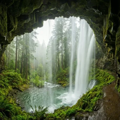
Munson Creek Falls State Natural Site is a state natural site in Tillamook County, Oregon, approximately 7 miles south of the city of Tillamook. The site protects the tallest waterfall in Oregon’s Coast Range — a 319-foot cascade — accessible via an easy 0.3-mile trail through old-growth forest along Munson Creek.
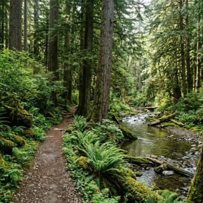
Munson Creek Falls is a 319-foot waterfall — the tallest in Oregon’s Coast Range — plunging through a canopy of old-growth Sitka spruce, western red cedar, and Douglas-fir. The experience is intimate: an easy 0.3-mile trail follows Munson Creek through towering forest to a viewing area at the base of the falls. The cascade threads through a mossy gorge, splitting and cascading over multiple rock ledges. Views of the falls are best in winter and early spring when deciduous trees have dropped their leaves, revealing the full height of the waterfall. In summer, foliage partially obscures the upper tiers. The old-growth forest itself is worth the visit — massive trees draped in moss and fern create a Pacific Northwest rainforest atmosphere even on the shortest walk.
Things to Do
Waterfall Viewing
- 319-foot waterfall — tallest in Oregon’s Coast Range
- Multi-tier cascade through mossy gorge
- Viewing area at end of trail
- Best views: winter/early spring (no leaf cover)
Hiking
- 0.3-mile trail (one way) — ~0.6 miles round trip
- Easy difficulty
- Old-growth forest canopy
- Follows Munson Creek
Nature
- Old-growth Sitka spruce, western red cedar, Douglas-fir
- Sword ferns, mosses, lichens
- Banana slugs, salamanders
- Rainforest atmosphere
Park Information
| Feature | Details |
|---|---|
| Waterfall | 319 feet — tallest in Oregon Coast Range |
| Trail | 0.3 mi one way (~0.6 mi RT) — easy |
| Location | Tillamook County, OR — 7 mi south of Tillamook |
| Access | Munson Creek Rd off US-101 — 1.5 mi gravel road to trailhead |
| Forest | Old-growth Sitka spruce, cedar, Douglas-fir |
| Facilities | Small parking area — no restrooms, no water |
| Camping | NOT permitted |
| Fees | FREE — no parking pass required |
| Coordinates | 45.3657° N, 123.7736° W |
Best Time to Visit
| Season | Highlights | Considerations |
|---|---|---|
| Winter (Dec–Feb) | ⭐ BEST VIEWS: Full waterfall visibility (no leaves); peak water flow; rainforest green; mossy atmosphere | Rain likely; muddy trail; cold; short days |
| Spring (Mar–May) | Strong water flow; wildflowers; birdsong; fern unfurling; trilliums; clearing weather | Muddy trail; rain still possible; can be slippery |
| Fall (Sep–Nov) | Autumn colors; leaf drop reveals falls; mushroom season; salmon in Coast Range creeks | Increasing rain; wet trail; shorter days |
| Summer (Jun–Aug) | Warmest; driest; lush canopy; old-growth shade; long days | Upper falls partially obscured by foliage; reduced water flow; popular |
Visitor Tips
- 319 feet: This is the tallest waterfall in Oregon’s Coast Range — the cascade threads through old-growth forest over multiple tiers.
- Winter views: Visit in winter or early spring for the best views — deciduous trees obscure the upper falls in summer.
- Easy trail: The 0.3-mile trail is easy and suitable for families — follows Munson Creek through magnificent old-growth.
- Access road: The 1.5-mile gravel road to the trailhead is generally passable for passenger cars but can be rough — drive slowly.
- No facilities: No restrooms or water at the trailhead — use facilities in Tillamook before visiting.
- Combine: The Tillamook Creamery is 7 miles north — a popular complement to a waterfall hike.
Frequently Asked Questions
Wildlife & Nature
Munson Creek Falls SNS — features the tallest waterfall in the Oregon Coast Range — a 319-foot cascade through a grove of old-growth Sitka spruce and western red cedar. Banana slugs, rough-skinned newts, and varied thrushes inhabit the lush forest.
Nearby Attractions
Tillamook — 7 miles north. Cape Lookout SP — 8 miles west. Three Capes Scenic Route — nearby.
How tall is Munson Creek Falls in Oregon?
Munson Creek Falls is 319 feet tall, making it the tallest waterfall in Oregon’s Coast Range. The falls are located in Tillamook County, about 7 miles south of the city of Tillamook. An easy 0.3-mile trail through old-growth forest leads to a viewing area. The falls cascade over multiple tiers through a mossy gorge of Sitka spruce, western red cedar, and Douglas-fir. For the best views, visit in winter or early spring when deciduous trees are bare. The site is free with no parking pass required. Access is via a 1.5-mile gravel road off US-101.
Last updated: May 2026
More parks nearby: Cape Lookout State Park is a short drive away, while Oceanside Beach State Recreation Site lies a short drive away.