Kennebec Highlands
🏆 6,000-Acre Lake Region — 6,126 acres of pristine ponds and forested ridges in central Maine — premier remote hiking
🏆 6,000-Acre Lake Region — 6,126 acres of pristine ponds and forested ridges in central Maine — premier remote hiking

Little Moose is a public land unit just west of Greenville in Piscataquis County, Maine. The Maine Bureau of Parks and Lands calls it the Little Moose Management Unit and says it covers more than 15,000 acres in Moosehead Junction and Big Moose townships. It takes in most of the Little Moose Mountain Range and…
🏆 Wild Atlantic Salmon River — One of the last wild Atlantic salmon rivers in the US — 60+ miles

🏆 AT’s Toughest Mile — 27,253-acre wilderness containing the most notoriously difficult mile on the entire 2,190-mile Appalachian Trail Mahoosuc

Moosehead Lake Public Land is the Maine Bureau of Parks and Lands’ name for the state-held lands around Moosehead Lake in Piscataquis County. It is made up of shoreline tracts, islands and state land on Mount Kineo, with primitive campsites, boat launches and hiking trails. This page covers those lands, not the lake as a…
🏔️ Maine Public Land — About 6,200 acres of state-owned land around Mount Abraham, most of it a State Ecological

🏆 100-Mile Wilderness AT — 43,000-acre wilderness unit on the Appalachian Trail’s legendary 100-Mile Wilderness Nahmakanta Public Reserved Land covers
🏆 Remote Paddling Corridor — More than 67 miles of river and 70 miles of lake frontage in Maine’s undeveloped

🏆 Public Farm Campus — 868-acre former state farm campus in New Gloucester — now a vibrant public recreation and

🏆 Rangeley Gem — Richardson Lake — one of the most pristine deep-water lakes in the eastern US, legendary for
🏆 Downeast Gem — Pristine Downeast lake surrounded by 10,000+ acres of conserved land — loon paradise Rocky Lake Public
🏆 Allagash Chain Link — Remote pond on the Allagash Wilderness Waterway — a critical link in the 92-mile canoe
🏆 Ecological Wonder — Pristine peatland ecosystem surrounding a 130-acre lake — one of the most important bogs in northern

🏆 Aroostook Wilderness — Remote 5,000-acre lot on Scopan Lake — deep in Maine’s Aroostook County backcountry Scopan is a

🏆 Remote North Woods — Pristine backcountry lake in the North Woods — accessible only by logging roads Scraggly Lake
🏆 East Branch Wilderness — 9,600-acre wilderness unit along the East Branch of the Penobscot — Thoreau’s canoe route Seboeis
🏆 Wild North — Massive 61,000-acre wilderness in the Upper Moose River region — one of the largest conservation acquisitions
🏆 King William’s War — 1690s garrison site from the deadliest conflict on the Maine frontier — King William’s War
🏆 Telos Cut Gateway — Remote wilderness lake on the Allagash — site of the 1841 Telos Cut that changed

Tumbledown Public Land is a Maine Bureau of Parks and Lands property in T6 North of Weld, managed together with Mount Blue State Park under a regional plan adopted in 2022.

Wassataquoik is a 2,099-acre Maine Public Reserved Land unit along the East Branch of the Penobscot River and Wassataquoik Stream in Penobscot County. Vehicles must stop one mile short of the property because two bridges are gone. Road access ends early. Two bridges on adjoining private land are gone, so you cannot drive to this…

🏆 2,200-Year-Old Oyster Feast — Largest prehistoric shell midden on the Maine coast — 2,200 years of Native oyster harvesting

🏆 Antique Capital Forest — 3,266-acre state forest near Brimfield — home of the world-famous Brimfield Antique Flea Market Brimfield
🏆 Norfolk Wetland — 141-acre wetland reservation in Norfolk with boardwalk trails through Atlantic white cedar swamp Bristol Blake State
🏆 Transcendentalist Utopia — Site of the 1841–1847 Brook Farm utopian community — where Hawthorne, Emerson, and Thoreau debated paradise
🏆 Urban Environmental Ed — Environmental education camp in Saugus providing outdoor learning for Boston-area students Camp Nihan Environmental Education

🏆 Industrial Revolution Trail — Rail trail along the historic Turners Falls Canal — America’s first navigational canal (1798!) Canalside

🏆 Emerald Necklace Gem — 120-acre reservoir park in Newton/Brighton — part of Boston’s legendary Emerald Necklace park system Chestnut

🏆 Garden Paradise — 182-acre reservation on the Charles River featuring the Massachusetts Horticultural Society gardens Elm Bank Reservation covers

🏆 Women’s Conservation — State forest donated by the Massachusetts Federation of Women’s Clubs in the 1920s — early environmental

🏆 Harbor Defense — Revolutionary War and WWII fortification with panoramic views of Boston Harbor Fort Revere Park preserves military

🏆 North Shore Forest — 1,112-acre mixed forest on the North Shore with trails through pine and wetland Georgetown-Rowley State

🏆 Western MA Wilderness — 2,426-acre forest in the Berkshire foothills with a stunning gorge and waterfall Granville State Forest

🏆 Newton Suburbia Oasis — 113-acre wooded oasis next to the Chestnut Hill Mall in one of Boston’s most affluent

🏆 Berkshire Crown Jewel — 1,158 acres of pristine Berkshire meadows and summits with AT views — one of MA’s
🏆 Berkshire Wilderness — 7,882-acre state forest with the highest trail in the Berkshires and spectacular fire tower views Kenneth

⚠️ Closed to the public since 2009 — the former beach is now used by the Massachusetts Environmental Police Lake
🏆 Merrimack Valley Forest — 1,100-acre tri-town forest along the Merrimack River — Mill City heritage meets nature Lowell-Dracut-Tyngsboro State

🏆 Urban River Revival — 3.5-mile trail along the revitalized Neponset River — from industrial wasteland to urban greenway Lower

Lynn Veterans Memorial Park, formerly Lynn Heritage State Park, is a 4.5-acre Massachusetts Heritage State Park on Lynn Harbor, under

🏆 North Shore Promenade — 2-mile oceanfront promenade along Lynn Shore Drive with sweeping views of Nahant Bay Lynn Shore
🏆 Martha’s Vineyard Forest — 5,343-acre state forest in the center of Martha’s Vineyard — protecting the island’s unique sandplain

Mass Central Rail Trail—Wayside is a shared-use rail trail the Massachusetts Department of Conservation and Recreation (DCR) is building on

🏆 America’s First Public Forest — 2,575 acres just 6 miles from Boston — one of the oldest public forests
🏆 Southern Berkshire Summit — 1,606-foot summit with some of the finest views in southern New England — AT and
🏆 Fire Tower Summit — 1,617-acre forest with a restored fire tower offering 360° views of the North Quabbin highlands

🏆 HIGHEST POINT IN MASSACHUSETTS — 3,491 feet! The only subalpine ecosystem in southern New England — Veterans Memorial Tower,

🏆 Connecticut Valley Overlook — Volcanic summit overlooking the Pioneer Valley — one of the most photographed views in New
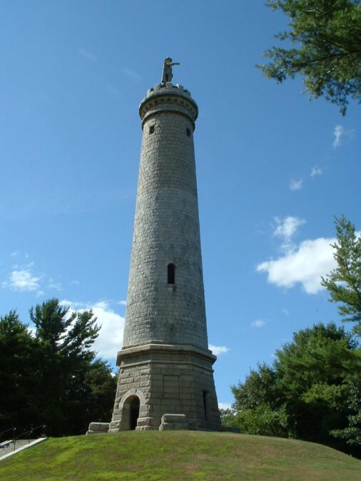
🏆 Pilgrim Monument — 116-foot granite monument on Captain’s Hill honoring Myles Standish — military captain of Plymouth Colony Myles

🏆 Urban River Park — Linear park along the Mystic River through Boston’s inner suburbs — greenway connecting communities Mystic